Difference between revisions of "2016-07-05 52 1"
From Geohashing
imported>Sourcerer (→Planning) |
imported>FippeBot m (Location) |
||
| (4 intermediate revisions by one other user not shown) | |||
| Line 17: | Line 17: | ||
== Plans == | == Plans == | ||
| − | + | Go after sunset. | |
== Expedition == | == Expedition == | ||
| − | + | This was close to home and easy enough. There was a roadside parking place. Narrow lanes led to the field. Tractor tracks through the ripening wheat crop led to the hashpoint. The quiet rural idyll was spoiled by a large noisy air conditioning plant serving multiple mushroom growing sheds. Further in the distance fans were howling, air blast drying crops after the wet weather. This was industrial farming. | |
== Photos == | == Photos == | ||
<gallery caption="Photo Gallery" widths="200px" heights="200px" perrow="3"> | <gallery caption="Photo Gallery" widths="200px" heights="200px" perrow="3"> | ||
| + | Image:2016-07-05_52_1_Sourcerer_1467755476809.jpg | Arrived. [http://www.openstreetmap.org/?lat=52.42059410&lon=1.39428198&zoom=16&layers=B000FTF @52.4206,1.3943] | ||
| + | Image:2016-07-05 52 1 Sourcerer.jpg | Google Earth Track | ||
</gallery> | </gallery> | ||
== Achievements == | == Achievements == | ||
{{#vardefine:ribbonwidth|800px}} | {{#vardefine:ribbonwidth|800px}} | ||
| + | |||
| + | {{Last man standing | ||
| + | | latitude = 52 | ||
| + | | longitude = 1 | ||
| + | | date = 2016-07-05 | ||
| + | | gender = man | ||
| + | | name = Sourcerer | ||
| + | }} | ||
{{Sourcerer_links | {{Sourcerer_links | ||
| prev = 2016-07-04 51 1 | | prev = 2016-07-04 51 1 | ||
| curr = 2016-07-05 52 1 | | curr = 2016-07-05 52 1 | ||
| − | | next = 2016-07- | + | | next = 2016-07-08 52 1 |
| date = 2016-07-05 | | date = 2016-07-05 | ||
}} | }} | ||
| − | |||
| − | |||
[[Category:Expeditions]] | [[Category:Expeditions]] | ||
[[Category:Expeditions with photos]] | [[Category:Expeditions with photos]] | ||
[[Category:Coordinates reached]] | [[Category:Coordinates reached]] | ||
| − | + | {{location|GB|ENG|SFK}} | |
Latest revision as of 00:56, 16 August 2019
| Tue 5 Jul 2016 in Norwich, UK: 52.4206278, 1.3942689 geohashing.info google osm bing/os kml crox |
Location
In a field, close to the perimeter, 5 km from home, at Flixton, Suffolk, UK.
Participants
Plans
Go after sunset.
Expedition
This was close to home and easy enough. There was a roadside parking place. Narrow lanes led to the field. Tractor tracks through the ripening wheat crop led to the hashpoint. The quiet rural idyll was spoiled by a large noisy air conditioning plant serving multiple mushroom growing sheds. Further in the distance fans were howling, air blast drying crops after the wet weather. This was industrial farming.
Photos
- Photo Gallery
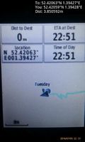
Arrived. @52.4206,1.3943
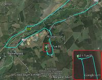
Google Earth Track


Achievements
Sourcerer earned the Last man standing achievement
|
Expeditions and Plans
| 2016-07-05 | ||
|---|---|---|
| Concord, New Hampshire | Mcbaneg, Katja, Rebekah, Susanne, Thomas | Newfound Lake, Bridgewater, NH |
| Norwich, United Kingdom | Sourcerer | In a field, close to the perimeter, 5 km from home, at Flixton, Suffolk, UK... |
Sourcerer's Expedition Links
2016-07-04 51 1 - 2016-07-05 52 1 - 2016-07-08 52 1 - KML file download of Sourcerer's expeditions for use with Google Earth.