Difference between revisions of "2016-07-11 52 1"
imported>Sourcerer m ([live] Arrived.) |
imported>FippeBot m (Location) |
||
| (2 intermediate revisions by one other user not shown) | |||
| Line 21: | Line 21: | ||
== Expedition == | == Expedition == | ||
| + | *Arrived. -- [[User:Sourcerer|Sourcerer]] ([[User talk:Sourcerer|talk]]) [http://www.openstreetmap.org/?lat=52.47793436&lon=1.55098200&zoom=16&layers=B000FTF @52.4779,1.5510] 00:03, 11 July 2016 (GMT+01:00) | ||
| + | Parked in the lay-by, the hashpoint was 30 metres away. A short walk got the distance down to about 12 metres. Slightly further on there was a gap in the dense vegetation giving access to the woodland. This was likely to be unpleasant but could have been much worse as there was a McDonald's half a mile away where desperate people could have a McCrap! There was a lot of litter and some fly-tipped black plastic sacks, far too much to attempt a geotrash collection. Under the canopy there was little vegetation and zeroing the distance was easy enough apart from some reception instability under the trees. | ||
| + | The hashpoint was half a kilometre from the site of a [https://en.wikipedia.org/wiki/Haughey_Air_AgustaWestland_AW139_crash helicopter crash] on March 13<sup>th</sup> 2014, giving a creepy feel. The aircraft had taken off from Gillingham Hall pictured in the image below. | ||
| − | |||
== Photos == | == Photos == | ||
<gallery caption="Photo Gallery" widths="200px" heights="200px" perrow="3"> | <gallery caption="Photo Gallery" widths="200px" heights="200px" perrow="3"> | ||
| − | |||
Image:2016-07-11_52_1_Sourcerer_1468191574000.jpg | Arrived. [http://www.openstreetmap.org/?lat=52.46708420&lon=1.55980080&zoom=16&layers=B000FTF @52.4671,1.5598] | Image:2016-07-11_52_1_Sourcerer_1468191574000.jpg | Arrived. [http://www.openstreetmap.org/?lat=52.46708420&lon=1.55980080&zoom=16&layers=B000FTF @52.4671,1.5598] | ||
| + | Image:2016-07-11 52 1 Sourcerer.jpg | Google Earth Track | ||
</gallery> | </gallery> | ||
| Line 45: | Line 47: | ||
| prev = 2016-07-10 52 1 | | prev = 2016-07-10 52 1 | ||
| curr = 2016-07-11 52 1 | | curr = 2016-07-11 52 1 | ||
| − | | next = 2016-07- | + | | next = 2016-07-15 52 1 |
| date = 2016-07-11 | | date = 2016-07-11 | ||
}} | }} | ||
| − | |||
| − | |||
[[Category:Expeditions]] | [[Category:Expeditions]] | ||
[[Category:Expeditions with photos]] | [[Category:Expeditions with photos]] | ||
[[Category:Coordinates reached]] | [[Category:Coordinates reached]] | ||
| − | + | {{location|GB|ENG|NFK}} | |
Latest revision as of 11:43, 16 August 2019
| Mon 11 Jul 2016 in Norwich, UK: 52.4778605, 1.5510431 geohashing.info google osm bing/os kml crox |
Location
Woodland beside a lay-by north of Gillingham, Norfolk, UK.
Participants
Plans
Two of two spanning midnight - 2016-07-10 52 1 - 2016-07-11 52 1 - ETA 00:00.
Expedition
- Arrived. -- Sourcerer (talk) @52.4779,1.5510 00:03, 11 July 2016 (GMT+01:00)
Parked in the lay-by, the hashpoint was 30 metres away. A short walk got the distance down to about 12 metres. Slightly further on there was a gap in the dense vegetation giving access to the woodland. This was likely to be unpleasant but could have been much worse as there was a McDonald's half a mile away where desperate people could have a McCrap! There was a lot of litter and some fly-tipped black plastic sacks, far too much to attempt a geotrash collection. Under the canopy there was little vegetation and zeroing the distance was easy enough apart from some reception instability under the trees.
The hashpoint was half a kilometre from the site of a helicopter crash on March 13th 2014, giving a creepy feel. The aircraft had taken off from Gillingham Hall pictured in the image below.
Photos
- Photo Gallery

Arrived. @52.4671,1.5598
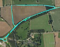
Google Earth Track


Achievements
Sourcerer earned the Midnight Geohash achievement
|
Expeditions and Plans
| 2016-07-11 | ||
|---|---|---|
| San Francisco, California | Erik, his roommate, Greg. | Outside a hotel in East Palo Alto. |
| Corning, New York | Mcbaneg | power line right-of-way near Alderman Road, Wayne, NY |
| Norwich, United Kingdom | Sourcerer | Woodland beside a lay-by north of Gillingham, Norfolk, UK. |
| Berlin, Germany | DaSteph | located on scubland in Berlin-Biesdorf. |
Sourcerer's Expedition Links
2016-07-10 52 1 - 2016-07-11 52 1 - 2016-07-15 52 1 - KML file download of Sourcerer's expeditions for use with Google Earth.