Difference between revisions of "2016-09-18 52 4"
imported>FelixTheCat (Created page with "{{subst:Expedition |lat = 52 |lon = 4 |date = 2016-09-18 }}") |
imported>FippeBot m (Location) |
||
| (3 intermediate revisions by one other user not shown) | |||
| Line 1: | Line 1: | ||
| − | |||
| − | |||
| − | |||
| − | |||
| − | |||
| − | |||
| − | |||
| − | |||
| − | |||
| − | |||
{{meetup graticule | {{meetup graticule | ||
| lat=52 | | lat=52 | ||
| Line 14: | Line 4: | ||
| date=2016-09-18 | | date=2016-09-18 | ||
}} | }} | ||
| − | |||
| − | |||
__NOTOC__ | __NOTOC__ | ||
| − | |||
== Location == | == Location == | ||
| − | + | On the outskirts of Nootdorp, Zuid-Holland province. | |
== Participants == | == Participants == | ||
| − | + | [[User:FelixTheCat|FelixTheCat]] ([[User talk:FelixTheCat|talk]]) | |
| − | |||
| − | == | + | == Expedition == |
| − | + | After completing [[2016-09-18_52_5 | today's expedition in 52 5]], there were still a few hours left before dark. So I decided to get on my bike and get some exercise by visiting today's hash in 52 4 as well. It was only about 8 km from my house, and right next to a bike path, so it was pretty straightforward to reach. It was a rather empty part of Nootdorp, actually just some grassy areas between Nootdorp and Zoetermeer. There were a few trees and some greenhouses. There were a few cyclists and the odd jogger. That's about it :-) | |
| − | + | But, I did score my first multihash! I think that's quite a feat, since in this part of the world it's not very common that any random geohash is actually accessible (meaning not in water, someone's back yard or a field full of raging bulls), let alone two on the same day within a reasonable distance! | |
| − | |||
| − | + | Also, it seems like I was the only one to report an expedition for this day, so I hereby claim the Last Man Standing Award! | |
| − | |||
== Photos == | == Photos == | ||
| Line 39: | Line 23: | ||
--> | --> | ||
<gallery perrow="5"> | <gallery perrow="5"> | ||
| + | Image: 2016-09-18 52 4 FelixTheCat 1.JPG | My bike at the hash. | ||
| + | Image: 2016-09-18 52 4 FelixTheCat 2.JPG | My bike again, plus greenhouse and jogger. | ||
| + | Image: 2016-09-18 52 4 FelixTheCat 3.png | GPS proof. | ||
| + | Image: 2016-09-18 52 4 FelixTheCat 4.JPG | Lloyd posing. | ||
</gallery> | </gallery> | ||
== Achievements == | == Achievements == | ||
{{#vardefine:ribbonwidth|800px}} | {{#vardefine:ribbonwidth|800px}} | ||
| − | + | {{bicycle geohash | |
| − | + | | latitude = 52 | |
| − | + | | longitude = 4 | |
| − | + | | date = 2016-09-18 | |
| − | [[ | + | | name = [[User:FelixTheCat|FelixTheCat]] ([[User talk:FelixTheCat|talk]]) |
| − | + | | distance = 8 km | |
| − | + | }} | |
| − | + | {{Multihash2 | |
| − | + | | date = 2016-09-18 | |
| − | + | | count = 2 | |
| − | [[ | + | | name = [[User:FelixTheCat|FelixTheCat]] ([[User talk:FelixTheCat|talk]]) |
| − | + | }} | |
| + | {{Last man standing | ||
| + | | latitude = 52 | ||
| + | | longitude = 4 | ||
| + | | date = 2016-09-18 | ||
| + | | gender = man | ||
| + | | name = [[User:FelixTheCat|FelixTheCat]] ([[User talk:FelixTheCat|talk]]) | ||
| + | }} | ||
| − | |||
| − | |||
| − | |||
[[Category:Expeditions]] | [[Category:Expeditions]] | ||
| − | |||
[[Category:Expeditions with photos]] | [[Category:Expeditions with photos]] | ||
| − | |||
| − | |||
| − | |||
| − | |||
| − | |||
[[Category:Coordinates reached]] | [[Category:Coordinates reached]] | ||
| − | + | {{location|NL|ZH}} | |
| − | |||
| − | |||
| − | |||
| − | |||
| − | |||
| − | |||
| − | |||
| − | |||
| − | |||
| − | |||
| − | |||
| − | |||
| − | |||
| − | |||
| − | |||
| − | |||
| − | |||
Latest revision as of 01:28, 16 August 2019
| Sun 18 Sep 2016 in 52,4: 52.0477821, 4.4335369 geohashing.info google osm bing/os kml crox |
Location
On the outskirts of Nootdorp, Zuid-Holland province.
Participants
Expedition
After completing today's expedition in 52 5, there were still a few hours left before dark. So I decided to get on my bike and get some exercise by visiting today's hash in 52 4 as well. It was only about 8 km from my house, and right next to a bike path, so it was pretty straightforward to reach. It was a rather empty part of Nootdorp, actually just some grassy areas between Nootdorp and Zoetermeer. There were a few trees and some greenhouses. There were a few cyclists and the odd jogger. That's about it :-)
But, I did score my first multihash! I think that's quite a feat, since in this part of the world it's not very common that any random geohash is actually accessible (meaning not in water, someone's back yard or a field full of raging bulls), let alone two on the same day within a reasonable distance!
Also, it seems like I was the only one to report an expedition for this day, so I hereby claim the Last Man Standing Award!
Photos
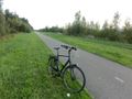
My bike at the hash.
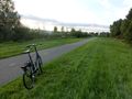
My bike again, plus greenhouse and jogger.
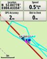
GPS proof.
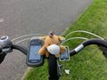
Lloyd posing.


Achievements
FelixTheCat (talk) earned the Bicycle geohash achievement
|
FelixTheCat (talk) earned the Multihash Achievement
|
FelixTheCat (talk) earned the Last man standing achievement
|