Difference between revisions of "2016-11-16 52 1"
From Geohashing
imported>Sourcerer m (→New expedition) |
imported>FippeBot m (Location) |
||
| Line 43: | Line 43: | ||
[[Category:Expeditions with photos]] | [[Category:Expeditions with photos]] | ||
[[Category:Coordinates reached]] | [[Category:Coordinates reached]] | ||
| + | {{location|GB|ENG|NFK}} | ||
Latest revision as of 01:45, 16 August 2019
| Wed 16 Nov 2016 in Norwich, UK: 52.6592821, 1.4637061 geohashing.info google osm bing/os kml crox |
Location
A public footpath and meadow between Pedham and Panxworth, Norfolk, UK.
Participants
Plans
No plan. Just went for it.
Expedition
This was an easy point to reach after walking with the Waveney Ramblers. A public footpath led into the meadow and the hashpoint was in the middle of a damp and open clump of trees in a nettle patch. After early morning sun, it had become grey and damp. Eeyore would have loved it.
Photos
- Photo Gallery

Proof
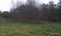
The ckump of trees
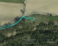
Google Earth Track


Achievements
Expeditions and Plans
| 2016-11-16 | ||
|---|---|---|
| Norwich, United Kingdom | Sourcerer | A public footpath and meadow between Pedham and Panxworth, Norfolk, UK. |
Sourcerer's Expedition Links
2016-11-14 52 1 - 2016-11-16 52 1 - 2016-11-17 52 1 - KML file download of Sourcerer's expeditions for use with Google Earth.