Difference between revisions of "2016-11-27 48 12"
imported>TheOneRing |
imported>FippeBot m (Location) |
||
| Line 44: | Line 44: | ||
[[Category:Expeditions with photos]] | [[Category:Expeditions with photos]] | ||
[[Category:Coordinates reached]] | [[Category:Coordinates reached]] | ||
| + | {{location|DE|BY|LA}} | ||
Latest revision as of 01:47, 16 August 2019
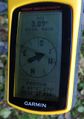
| Sun 27 Nov 2016 in 48,12: 48.4544855, 12.4655670 geohashing.info google osm bing/os kml crox |
Location
The geohash is on a field near Vilsbiburg.
Who Went
TheOneRing - by car.
The Expedition
SIX. IN. A. ROW.
A new birthday and a new successful birthday geohash. The general selection was sparse, as geohashes in some graticules were in the Alpes. I chose the Landshut graticule and went by car.
The route was autobahn until Landshut and other streets from there. I passed Vilsbiburg and had desperately to fill the tank. Therefore, it was time for a rest. After paying, I continued my way. Near the geohash, there was something that looked like a parking lot. I am not sure, whether it was really a parking lot, but it was sufficient for me.
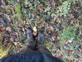
From there it was about 850m to the geohash. The field tracks were in good conditions, after a while I reached a forest. On the edge 400m further there was the geohash.
I took the usual photographs and had a small rest. Finally, I walked back to my car a different way.
Wonderful trip, which I concluded with a visit of Vilsbiburg and with some coffee and (birthday) cake.
Photos
Coordinates reached
Here it is
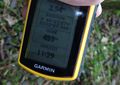
Some more infos
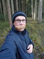
Me at the picnic break
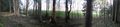
Forestal panoramic view over the geohash
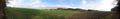
Better view from outside the forest


Achievements
TheOneRing earned the Land geohash achievement
|
TheOneRing earned the Birthday Geohash Achievement
|
TheOneRing earned the Picnic achievement
|