Difference between revisions of "2017-01-29 52 0"
imported>Sourcerer (→Plans) |
imported>FippeBot m (Location) |
||
| (11 intermediate revisions by one other user not shown) | |||
| Line 17: | Line 17: | ||
== Plans == | == Plans == | ||
| − | Two creek wades will be needed. Low tide is at about 15:20 UTC. In the summer, this would be easy. In January, not so much. I have a track-log of a walk here on 2008-08-26 before I started geohashing. | + | Two creek wades will be needed. Low tide is at about 15:20 UTC. In the summer, this would be easy. In January, not so much. I have a track-log of a walk here on [https://www.wikiloc.com/wikiloc/view.do?id=185942 2008-08-26] before I started geohashing. |
== Expedition == | == Expedition == | ||
| + | I wondered if I'd be considered insane wading the creeks in January rain with a temperature of 6C. It turned out that I was far from the first. Several bird watchers and other eccentrics had left their footprints in the mud. The car park was surprisingly full for the time of year so I had an audience. I met three other people on the path to the hashpoint. The path was slippery but passable. The creek wade was cold and a tad painful as the foot and shin muscles cooled rapidly with cramp sensations. Luckily it was a spring tide and the water was as low as it ever gets so the wade was short. The second creek was almost dry. In places the black anaerobic mud was ankle deep. What fun! It all washed off on the return wade but enough was left to stink out the car on the drive home. | ||
| + | In the photos below, the blue track is today's expedition. The brown is my expedition record from 2008 saved on [https://www.wikiloc.com/wikiloc/view.do?id=185942 Wikiloc]. | ||
| + | |||
| + | After dry icy Arctic weather for several weeks, milder wet Atlantic air had arrived. There was intermittent light rain for the walk. This became heavy on the drive home. | ||
== Photos == | == Photos == | ||
| − | <gallery caption=" | + | <gallery caption="Gallery" widths="200px" heights="200px" perrow="3"> |
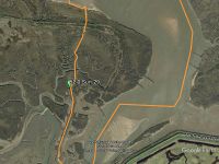
Image:2017-01-29_52_0_Sourcerer_DJV.jpg | Déjà vu Google Earth Track from 2008 | Image:2017-01-29_52_0_Sourcerer_DJV.jpg | Déjà vu Google Earth Track from 2008 | ||
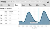
| + | Image:2017-01-29 52 0 Sourcerer Tide.jpg | Tide times. | ||
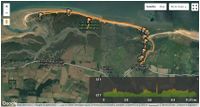
| + | Image:2017-01-29 52 0 Sourcerer 5.jpg | Déjà vu Track-log | ||
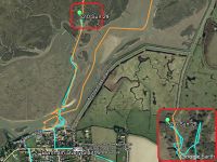
| + | Image:2017-01-29 52 0 Sourcerer.jpg | Google Earth Track | ||
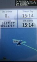
| + | Image:2017-01-29_52_0_Sourcerer_1485702838769.jpg | Arrived. [http://www.openstreetmap.org/?lat=52.97106922&lon=.74766576&zoom=16&layers=B000FTF @52.9711,.7477] | ||
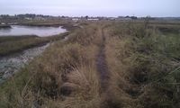
| + | Image:2017-01-29_52_0_Sourcerer_1.jpg | Damp January Terrain | ||
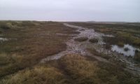
| + | Image:2017-01-29_52_0_Sourcerer_2.jpg | Damp January Terrain | ||
| + | Image:2017-01-29_52_0_Sourcerer_3.jpg | Damp January Terrain | ||
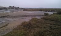
| + | Image:2017-01-29_52_0_Sourcerer_4.jpg | Damp January Terrain | ||
</gallery> | </gallery> | ||
== Achievements == | == Achievements == | ||
{{#vardefine:ribbonwidth|800px}} | {{#vardefine:ribbonwidth|800px}} | ||
| + | |||
| + | {{Déjà vu geohash | ||
| + | | latitude = 52 | ||
| + | | longitude = 0 | ||
| + | | date = 2017-01-29 | ||
| + | | olddate = 2008-08-26 | ||
| + | | name = Sourcerer | ||
| + | | image = 2017-01-29_52_0_Sourcerer_5.jpg | ||
| + | }} | ||
{{Sourcerer_links | {{Sourcerer_links | ||
| prev = 2017-01-24 52 1 | | prev = 2017-01-24 52 1 | ||
| curr = 2017-01-29 52 0 | | curr = 2017-01-29 52 0 | ||
| − | | next = 2017- | + | | next = 2017-02-10 52 1 |
| date = 2017-01-29 | | date = 2017-01-29 | ||
}} | }} | ||
| − | |||
| − | |||
[[Category:Expeditions]] | [[Category:Expeditions]] | ||
[[Category:Expeditions with photos]] | [[Category:Expeditions with photos]] | ||
[[Category:Coordinates reached]] | [[Category:Coordinates reached]] | ||
| − | + | [[Category:Insane]] | |
| + | {{location|GB|ENG|NFK}} | ||
Latest revision as of 02:04, 16 August 2019
| Sun 29 Jan 2017 in Cambridge, UK: 52.9710690, 0.7476478 geohashing.info google osm bing/os kml crox |
Location
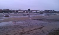
A salt marsh north of Burnham Overy Staithe, Norfolk, UK.
Participants
Plans
Two creek wades will be needed. Low tide is at about 15:20 UTC. In the summer, this would be easy. In January, not so much. I have a track-log of a walk here on 2008-08-26 before I started geohashing.
Expedition
I wondered if I'd be considered insane wading the creeks in January rain with a temperature of 6C. It turned out that I was far from the first. Several bird watchers and other eccentrics had left their footprints in the mud. The car park was surprisingly full for the time of year so I had an audience. I met three other people on the path to the hashpoint. The path was slippery but passable. The creek wade was cold and a tad painful as the foot and shin muscles cooled rapidly with cramp sensations. Luckily it was a spring tide and the water was as low as it ever gets so the wade was short. The second creek was almost dry. In places the black anaerobic mud was ankle deep. What fun! It all washed off on the return wade but enough was left to stink out the car on the drive home.
In the photos below, the blue track is today's expedition. The brown is my expedition record from 2008 saved on Wikiloc.
After dry icy Arctic weather for several weeks, milder wet Atlantic air had arrived. There was intermittent light rain for the walk. This became heavy on the drive home.
Photos
- Gallery
Arrived. @52.9711,.7477
Achievements
Sourcerer earned the Déjà Vu Geohash Achievement
|
Expeditions and Plans
| 2017-01-29 | ||
|---|---|---|
| Buffalo, New York | Pedalpusher, Ashley, Dane, Robin, Simon the dog, Myka the dog | In a field of Amherst State Park, just off a path |
| Innsbruck, Austria | Claralucia9 | In a forest close to Aying south of Munich |
| Pforzheim, Germany | DODO | A lawn near Ölbrunn. |
| Cambridge, United Kingdom | Sourcerer | A salt marsh north of Burnham Overy Staithe, Norfolk, UK. |
Sourcerer's Expedition Links
2017-01-24 52 1 - 2017-01-29 52 0 - 2017-02-10 52 1 - KML file download of Sourcerer's expeditions for use with Google Earth.
