Difference between revisions of "2017-03-08 47 -122"
From Geohashing
imported>Thomcat (Update details, remove New Expedition tag) |
imported>FippeBot m (Location) |
||
| Line 80: | Line 80: | ||
[[Category:Expeditions with photos]] | [[Category:Expeditions with photos]] | ||
[[Category:Coordinates reached]] | [[Category:Coordinates reached]] | ||
| + | {{location|US|WA|KN}} | ||
Latest revision as of 02:13, 16 August 2019
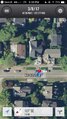
| Wed 8 Mar 2017 in Seattle: 47.6576468, -122.2771632 geohashing.info google osm bing/os kml crox |
Location
Just off the sidewalk in a Laurelhurst street.
Participants
- Zebburkeconte and
- friend Dillon of 2015-11-15 47 -122 fame
- Thomcat
Plans
Expedition
zebburkeconte
Finally, a walk geohash opportunity! I had taken a bus from home, but between when I saw the geohash (on campus) and reached it, it was walking-only, so I'm going to count it. Probably could have tronned it if we tried, but we didn't.
Thomcat
Great spot, but too busy to achieve it during a rainy day. Finally in the evening I carved out some time and drove southeast to where the hashpoint lay.
- Here -- Thomcat (talk) @47.6577,-122.2772 22:33, 8 March 2017 (PST)
It being dark in a residential neighborhood, I snapped a few photos and skedaddled.
Tracklog
Photos
zebburkeconte
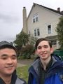
Cheesin'
Proof


Thomcat
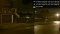
On the spot @47.6576,-122.2772

Geohasher @47.6577,-122.2772


Achievements
Zeb & Dillon earned the Walk geohash Achievement
|