Difference between revisions of "2008-06-01 -34 150"
imported>DancingMan m (typo) |
m (fix, sorry) |
||
| (10 intermediate revisions by 7 users not shown) | |||
| Line 10: | Line 10: | ||
-34.3491079341188037, 150.9162389042702137 | -34.3491079341188037, 150.9162389042702137 | ||
| − | Map reference: | + | Map reference: {{egl|2008-06-01|-34|150|text=Official tool}} |
[http://maps.google.com/maps?f=q&hl=en&geocode=&q=-34.3491079341188037,+150.9162389042702137&ie=UTF8&ll=-34.34911,150.916239&spn=0.006705,0.010042&t=h&z=17 Location in Google Maps] | [http://maps.google.com/maps?f=q&hl=en&geocode=&q=-34.3491079341188037,+150.9162389042702137&ie=UTF8&ll=-34.34911,150.916239&spn=0.006705,0.010042&t=h&z=17 Location in Google Maps] | ||
| Line 25: | Line 25: | ||
[[User:DancingMan|DancingMan]] 08:05, 1 June 2008 (UTC) | [[User:DancingMan|DancingMan]] 08:05, 1 June 2008 (UTC) | ||
| − | + | <gallery> | |
| − | + | Image:2008-06-01_-34_150_DSC_0022.JPG | |
| − | + | Image:2008-06-01_-34_150_DSC_0025.JPG | |
| − | + | Image:2008-06-01_-34_150_DSC_0026.JPG | |
| − | + | Image:2008-06-01_-34_150_DSC_0027.JPG | |
| − | + | Image:2008-06-01_-34_150_DSC_0028.JPG | |
| − | + | Image:2008-06-01_-34_150_DSC_0029.JPG | |
| − | + | Image:2008-06-01_-34_150_DSC_0030.JPG | |
| − | + | Image:2008-06-01_-34_150_DSC_0031.JPG | |
| − | + | Image:2008-06-01_-34_150_DSC_0032.JPG | |
| + | </gallery> | ||
---- | ---- | ||
| Line 41: | Line 42: | ||
Google's satellite photo showed the spot within number 10, so that's what my photo is of. | Google's satellite photo showed the spot within number 10, so that's what my photo is of. | ||
It was dark, so I had to use flash, and I didn't want anyone coming out to abuse me, so I only got the one shot (it's the one of the white fence). | It was dark, so I had to use flash, and I didn't want anyone coming out to abuse me, so I only got the one shot (it's the one of the white fence). | ||
| + | |||
[[Image:000_0105.jpg|thumb]] | [[Image:000_0105.jpg|thumb]] | ||
| − | [[Category: | + | [[Category:Expeditions]] |
| + | [[Category:Expeditions with photos]] | ||
| + | [[Category:Coordinates reached]] | ||
| + | {{location|AU|NSW|WG}} | ||
Latest revision as of 18:47, 18 January 2022
| Sun 1 Jun 2008 in -34,150: -34.3491079, 150.9162389 geohashing.info google osm bing/os kml crox |
This one falls at 12 Park Rd, Woonona. The train station is conveniently nearby.
-34.3491079341188037, 150.9162389042702137
Map reference: Official tool
Achievement
This hash was reached by me (DancingMan) at 15:50. I remained until 16:20, but no-one else showed up while I was there. Possibly, this had something to do with the gloomy, drizzling weather.
This suburb is mostly residential, single & double storey houses; a lot of them look quite new, or at least, have been given a lick of paint recently. There's a beach at the end of the road, but owing to the miserable weather, I didn't bother to go look.
Park Rd itself was far busier than I anticipated; there was a car going past at least every 10 seconds.
A couple of residents of No.12 arrived while I was waiting, however, they didn't look particularly friendly, so I didn't approach.
DancingMan 08:05, 1 June 2008 (UTC)
I (Mephistopheles) missed the designated time, but I did manage to get there at about 17:45.
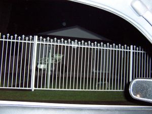
Google's satellite photo showed the spot within number 10, so that's what my photo is of.
It was dark, so I had to use flash, and I didn't want anyone coming out to abuse me, so I only got the one shot (it's the one of the white fence).


