Difference between revisions of "2017-06-08 47 11"
imported>Claralucia9 (An expedition message sent via Geohash Droid for Android.) |
m (Username changed) |
||
| (13 intermediate revisions by 3 users not shown) | |||
| Line 20: | Line 20: | ||
== Location == | == Location == | ||
<!-- where you've surveyed the hash to be --> | <!-- where you've surveyed the hash to be --> | ||
| + | In a forest close to Sauerlach south of Munich | ||
== Participants == | == Participants == | ||
| − | + | [[User:Clearlucid9|Claralucia9]] ([[User talk:Clearlucid9|talk]]) | |
| − | |||
== Plans == | == Plans == | ||
| Line 30: | Line 30: | ||
== Expedition == | == Expedition == | ||
<!-- how it all turned out. your narrative goes here. --> | <!-- how it all turned out. your narrative goes here. --> | ||
| + | Finally another geohash within reach! | ||
| + | I took the car to go to Sauerlach and parked at the industrial area. From there I headed off into the forest. 1.4 km according to my GPS and with a trail close to the hash. So I enjoyed a nice walk in the late afternoon sun, listening to birds and humming some songs myself... | ||
| + | Once close to the hash I had to leave the trail and try to find a way through the underwood. After some try and miss I finally got the direction right and found the right spot. There I took my pics and had to find my way back to the trail. | ||
| + | I really start to enjoy geohashing as an additional hobby to geocaching! :-) | ||
== Tracklog == | == Tracklog == | ||
| Line 39: | Line 43: | ||
--> | --> | ||
<gallery perrow="5"> | <gallery perrow="5"> | ||
| + | Image:2017-06-08 47 11 Claralucia9 1496941813568.jpg |logproof | ||
| + | Image:2017-06-08_19.10.35.jpg | Me at the hash :-) | ||
| + | Image:2017-06-08_18.55.02.jpg | way to the hash | ||
| + | Image:2017-06-08_19.10.46.jpg | view from the hash | ||
| + | Image:2017-06-08_19.10.49.jpg | trees, trees, trees - that's my way to the hash... | ||
</gallery> | </gallery> | ||
| Line 44: | Line 53: | ||
{{#vardefine:ribbonwidth|800px}} | {{#vardefine:ribbonwidth|800px}} | ||
<!-- Add any achievement ribbons you earned below, or remove this section --> | <!-- Add any achievement ribbons you earned below, or remove this section --> | ||
| + | {{land geohash | latitude = 47 | longitude = 11 | date = 2017-06-08 | name = Claralucia9 | ||
| + | }} | ||
| − | |||
| − | |||
| − | |||
| − | |||
| − | |||
| − | |||
| − | |||
| − | |||
| − | |||
| − | |||
| − | |||
| − | |||
| − | |||
| − | |||
[[Category:Expeditions]] | [[Category:Expeditions]] | ||
| − | |||
[[Category:Expeditions with photos]] | [[Category:Expeditions with photos]] | ||
| − | |||
| − | |||
| − | |||
| − | |||
| − | |||
[[Category:Coordinates reached]] | [[Category:Coordinates reached]] | ||
| − | + | {{location|DE|BY|M}} | |
| − | |||
| − | |||
| − | |||
| − | |||
| − | |||
| − | |||
| − | |||
| − | |||
| − | |||
| − | |||
| − | |||
| − | |||
| − | |||
| − | |||
| − | |||
| − | |||
| − | |||
Latest revision as of 12:33, 31 October 2021
| Thu 8 Jun 2017 in 47,11: 47.9605733, 11.6810721 geohashing.info google osm bing/os kml crox |
Location
In a forest close to Sauerlach south of Munich
Participants
Plans
Expedition
Finally another geohash within reach! I took the car to go to Sauerlach and parked at the industrial area. From there I headed off into the forest. 1.4 km according to my GPS and with a trail close to the hash. So I enjoyed a nice walk in the late afternoon sun, listening to birds and humming some songs myself... Once close to the hash I had to leave the trail and try to find a way through the underwood. After some try and miss I finally got the direction right and found the right spot. There I took my pics and had to find my way back to the trail. I really start to enjoy geohashing as an additional hobby to geocaching! :-)
Tracklog
Photos
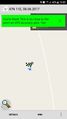
logproof
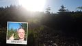
Me at the hash :-)
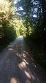
way to the hash
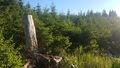
view from the hash
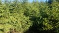
trees, trees, trees - that's my way to the hash...


Achievements
Claralucia9 earned the Land geohash achievement
|