Difference between revisions of "2017-06-24 52 1"
imported>Sourcerer m (→Expedition) |
imported>FippeBot m (Location) |
||
| (2 intermediate revisions by one other user not shown) | |||
| Line 25: | Line 25: | ||
The light shop was over half way to the hashpoint so it was a no brainer to combine the expeditions. | The light shop was over half way to the hashpoint so it was a no brainer to combine the expeditions. | ||
| − | An ambiguous footpath sign did not make it clear which side of the nettle margin to walk so I chose the right hand way. Later, this turned out not to be the footpath but | + | An ambiguous footpath sign did not make it clear which side of the nettle margin to walk so I chose the right hand way. Later, this turned out not to be the footpath but it was possible to follow the field margin without doing damage. 17 metres from the zero point, there was a low fence into the woodland. There were maturing beech trees, perhaps ready to harvest in another hundred years. The woodland margin was mostly nettles. Around the canopy edge there was a wide belt of bluebells gone to seed. In the deep dark wood, at the zero point, there was little undergrowth. |
== Photos == | == Photos == | ||
| Line 41: | Line 41: | ||
| prev = 2017-06-22 52 1 | | prev = 2017-06-22 52 1 | ||
| curr = 2017-06-24 52 1 | | curr = 2017-06-24 52 1 | ||
| − | | next = 2017- | + | | next = 2017-07-12 52 1 |
| date = 2017-06-24 | | date = 2017-06-24 | ||
}} | }} | ||
| Line 48: | Line 48: | ||
[[Category:Expeditions with photos]] | [[Category:Expeditions with photos]] | ||
[[Category:Coordinates reached]] | [[Category:Coordinates reached]] | ||
| + | {{location|GB|ENG|NFK}} | ||
Latest revision as of 02:41, 16 August 2019
| Sat 24 Jun 2017 in Norwich, UK: 52.8372724, 1.2267758 geohashing.info google osm bing/os kml crox |
Location
Beech woodland north of Aylsham, Norfolk, UK.
Participants
Plans
Buy a new fluorescent tube light and visit the hashpoint afterwards.
Expedition
My kitchen was plunged into darkness when the old fluorescent tube failed. The diffuser had turned brown with age so it was time to replace the entire unit. An LED version was on sale but the price was too high and the energy saving hardly worthwhile.
The light shop was over half way to the hashpoint so it was a no brainer to combine the expeditions.
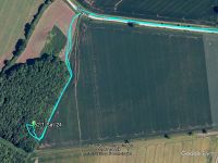
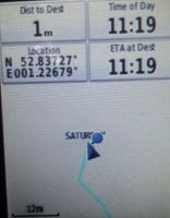
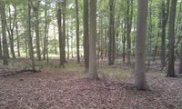
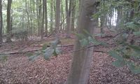
An ambiguous footpath sign did not make it clear which side of the nettle margin to walk so I chose the right hand way. Later, this turned out not to be the footpath but it was possible to follow the field margin without doing damage. 17 metres from the zero point, there was a low fence into the woodland. There were maturing beech trees, perhaps ready to harvest in another hundred years. The woodland margin was mostly nettles. Around the canopy edge there was a wide belt of bluebells gone to seed. In the deep dark wood, at the zero point, there was little undergrowth.
Photos
- Gallery
Achievements
Expeditions and Plans
| 2017-06-24 | ||
|---|---|---|
| Atlanta, Georgia | NWoodruff | In the front yard of a house in Tucker Georgia |
| Norwich, United Kingdom | Sourcerer | Beech woodland north of Aylsham, Norfolk, UK. |
Sourcerer's Expedition Links
2017-06-22 52 1 - 2017-06-24 52 1 - 2017-07-12 52 1 - KML file download of Sourcerer's expeditions for use with Google Earth.


