Difference between revisions of "2017-07-30 48 11"
From Geohashing
imported>Solli |
imported>FippeBot m (Location) |
||
| (One intermediate revision by one other user not shown) | |||
| Line 35: | Line 35: | ||
| longitude = 11 | | longitude = 11 | ||
| date = 2017-07-30 | | date = 2017-07-30 | ||
| + | | name = Solli | ||
| + | }} | ||
| + | |||
| + | {{Last man standing | ||
| + | | date = 2017-07-30 | ||
| + | | latitude = 48 | ||
| + | | longitude = 11 | ||
| name = Solli | | name = Solli | ||
}} | }} | ||
| Line 41: | Line 48: | ||
[[Category:Expeditions with photos]] | [[Category:Expeditions with photos]] | ||
[[Category:Coordinates reached]] | [[Category:Coordinates reached]] | ||
| + | {{location|DE|BY|ED}} | ||
Latest revision as of 02:48, 16 August 2019
| Sun 30 Jul 2017 in 48,11: 48.2522168, 11.9400508 geohashing.info google osm bing/os kml crox |
Location
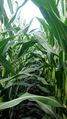
On a corn field near Hörlkofen
Participants
Plans
Just a little walk in the countryside...
Expedition
As it turned out the hashpoint was inside of a corn field. I parked the car north of the field and walked through a little grove to the southeastern corner of the field. Then I walked between the corn field and the wheat field to the south until I was only 15 m away from the location. The last few meters I had to go into the field, but I took care not to damage any plants.
Photos
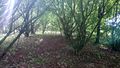
Lovely little grove
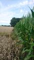
Wheat to the left, corn (and the hashpoint) to the right
Proof
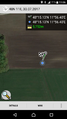
Where I decided the hashpoint was
View from the hashpoint
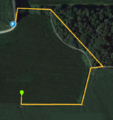
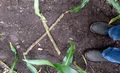
The path


Achievements
Solli earned the Land geohash achievement
|
Solli earned the Last man standing achievement
|