Difference between revisions of "2017-11-09 48 11"
From Geohashing
imported>FippeBot m (Location) |
m (Username changed) |
||
| Line 22: | Line 22: | ||
== Participants == | == Participants == | ||
| − | [[User: | + | [[User:Clearlucid9|Claralucia9]] ([[User talk:Clearlucid9|talk]]) |
== Plans == | == Plans == | ||
| Line 32: | Line 32: | ||
| − | *Reached at 16.55 -- [[User: | + | *Reached at 16.55 -- [[User:Clearlucid9|Claralucia9]] ([[User talk:Clearlucid9|talk]]) 16:57, 9 November 2017 (GMT+01:00) |
== Photos == | == Photos == | ||
Latest revision as of 12:35, 31 October 2021
| Thu 9 Nov 2017 in 48,11: 48.0189431, 11.6813990 geohashing.info google osm bing/os kml crox |
Location
In a forest close to Brunntal, south of Munich
Participants
Plans
Expedition
Darkness was about to fall when I reached the forest. I had brought a torch, but had a feeling I could just manage without one. So I left it in the car and set foot for the hash. Unfortunately this resulted in me not seeing the thorns of the bushes in my way... Despite this little obstacle I managed to get within less than a meter to today's coordinates according to my GPS. On my way back I chose a better path and were back to the car just when night finally fell.
- Reached at 16.55 -- Claralucia9 (talk) 16:57, 9 November 2017 (GMT+01:00)
Photos
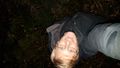
Me at hash
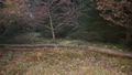
In the woods
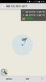
Logproof


