Difference between revisions of "2017-11-18 53 -2"
From Geohashing
imported>Jiml (Expand Template) |
m (Location correction) |
||
| (4 intermediate revisions by 4 users not shown) | |||
| Line 1: | Line 1: | ||
| − | |||
| − | |||
| − | |||
| − | |||
| − | |||
| − | |||
| − | |||
| − | |||
| − | |||
<!-- If you did not specify these parameters in the template, please substitute appropriate values for IMAGE, LAT, LON, and DATE (YYYY-MM-DD format) | <!-- If you did not specify these parameters in the template, please substitute appropriate values for IMAGE, LAT, LON, and DATE (YYYY-MM-DD format) | ||
| Line 18: | Line 9: | ||
And DON'T FORGET to add your expedition and the best photo you took to the gallery on the Main Page! We'd love to read your report, but that means we first have to discover it! :) | And DON'T FORGET to add your expedition and the best photo you took to the gallery on the Main Page! We'd love to read your report, but that means we first have to discover it! :) | ||
--> | --> | ||
| − | {{meetup graticule | + | {{meetup graticule |
| lat=53 | | lat=53 | ||
| lon=-2 | | lon=-2 | ||
| date=2017-11-18 | | date=2017-11-18 | ||
| + | | graticule_name=Manchester, UK | ||
| + | | graticule_link=Manchester, United Kingdom | ||
}} | }} | ||
| + | |||
| + | |||
<!-- edit as necessary --> | <!-- edit as necessary --> | ||
| Line 33: | Line 28: | ||
<!-- who attended: If you link to your wiki user name in this section, your expedition will be picked up by the various statistics generated for geohashing. You may use three tildes ~ as a shortcut to automatically insert the user signature of the account you are editing with. | <!-- who attended: If you link to your wiki user name in this section, your expedition will be picked up by the various statistics generated for geohashing. You may use three tildes ~ as a shortcut to automatically insert the user signature of the account you are editing with. | ||
--> | --> | ||
| + | * [[User:KarMann|KarMann]] | ||
== Plans == | == Plans == | ||
| Line 43: | Line 39: | ||
<!-- if your GPS device keeps a log, you may post a link here --> | <!-- if your GPS device keeps a log, you may post a link here --> | ||
| − | == Photos == | + | == Photos == |
| − | < | + | <gallery> |
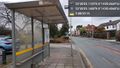
| − | Image: | + | Image:2017-11-18_53_-2_KarMann_1511021750138.jpg|My first UK hashpoint. This one was easy! [http://www.openstreetmap.org/?lat=53.37310060&lon=-2.23900190&zoom=16&layers=B000FTF @53.3731,-2.2390] -- [[User:KarMann|KarMann]] ([[User talk:KarMann|talk]]) 16:15, 18 November 2017 (GMT+00:00) |
| − | -- | ||
| − | |||
</gallery> | </gallery> | ||
| Line 54: | Line 48: | ||
<!-- Add any achievement ribbons you earned below, or remove this section --> | <!-- Add any achievement ribbons you earned below, or remove this section --> | ||
| − | |||
| − | |||
| − | |||
| − | |||
| − | |||
| − | |||
| − | |||
| − | |||
| − | |||
| − | |||
| − | |||
| − | |||
| − | |||
| − | |||
[[Category:Expeditions]] | [[Category:Expeditions]] | ||
| − | |||
[[Category:Expeditions with photos]] | [[Category:Expeditions with photos]] | ||
| − | |||
| − | |||
| − | |||
| − | |||
| − | |||
[[Category:Coordinates reached]] | [[Category:Coordinates reached]] | ||
| − | + | {{location|GB|ENG|SKP}} | |
| − | |||
| − | |||
| − | |||
| − | |||
| − | |||
| − | |||
| − | |||
| − | |||
| − | |||
| − | |||
| − | |||
| − | |||
| − | |||
| − | |||
| − | |||
| − | |||
| − | |||
| − | |||
| − | |||
| − | |||
| − | |||
| − | |||
| − | |||
| − | |||
| − | |||
Latest revision as of 20:36, 16 May 2020
| Sat 18 Nov 2017 in Manchester, UK: 53.3730867, -2.2389630 geohashing.info google osm bing/os kml crox |
Location
Participants
Plans
Expedition
Tracklog
Photos
My first UK hashpoint. This one was easy! @53.3731,-2.2390 -- KarMann (talk) 16:15, 18 November 2017 (GMT+00:00)
