Difference between revisions of "2017-11-18 53 -2"
From Geohashing
imported>Jiml (Add some details) |
m (Location correction) |
||
| (3 intermediate revisions by 3 users not shown) | |||
| Line 28: | Line 28: | ||
<!-- who attended: If you link to your wiki user name in this section, your expedition will be picked up by the various statistics generated for geohashing. You may use three tildes ~ as a shortcut to automatically insert the user signature of the account you are editing with. | <!-- who attended: If you link to your wiki user name in this section, your expedition will be picked up by the various statistics generated for geohashing. You may use three tildes ~ as a shortcut to automatically insert the user signature of the account you are editing with. | ||
--> | --> | ||
| + | * [[User:KarMann|KarMann]] | ||
== Plans == | == Plans == | ||
| Line 38: | Line 39: | ||
<!-- if your GPS device keeps a log, you may post a link here --> | <!-- if your GPS device keeps a log, you may post a link here --> | ||
| − | == Photos == | + | == Photos == |
| − | < | + | <gallery> |
| − | Image: | + | Image:2017-11-18_53_-2_KarMann_1511021750138.jpg|My first UK hashpoint. This one was easy! [http://www.openstreetmap.org/?lat=53.37310060&lon=-2.23900190&zoom=16&layers=B000FTF @53.3731,-2.2390] -- [[User:KarMann|KarMann]] ([[User talk:KarMann|talk]]) 16:15, 18 November 2017 (GMT+00:00) |
| − | -- | ||
| − | |||
</gallery> | </gallery> | ||
| Line 48: | Line 47: | ||
{{#vardefine:ribbonwidth|800px}} | {{#vardefine:ribbonwidth|800px}} | ||
<!-- Add any achievement ribbons you earned below, or remove this section --> | <!-- Add any achievement ribbons you earned below, or remove this section --> | ||
| − | |||
| − | |||
| − | |||
| − | |||
| − | |||
| − | |||
| − | |||
| − | |||
| − | |||
| − | |||
| − | |||
| − | |||
| − | |||
| − | |||
[[Category:Expeditions]] | [[Category:Expeditions]] | ||
[[Category:Expeditions with photos]] | [[Category:Expeditions with photos]] | ||
| − | |||
| − | |||
| − | |||
[[Category:Coordinates reached]] | [[Category:Coordinates reached]] | ||
| − | + | {{location|GB|ENG|SKP}} | |
| − | |||
| − | |||
| − | |||
| − | |||
| − | |||
| − | |||
| − | |||
| − | |||
| − | |||
| − | |||
| − | |||
| − | |||
| − | |||
| − | |||
| − | |||
| − | |||
| − | |||
| − | |||
| − | |||
| − | |||
| − | |||
| − | |||
| − | |||
| − | |||
| − | |||
Latest revision as of 20:36, 16 May 2020
| Sat 18 Nov 2017 in Manchester, UK: 53.3730867, -2.2389630 geohashing.info google osm bing/os kml crox |
Location
Participants
Plans
Expedition
Tracklog
Photos
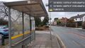
My first UK hashpoint. This one was easy! @53.3731,-2.2390 -- KarMann (talk) 16:15, 18 November 2017 (GMT+00:00)
