Difference between revisions of "2009-09-04 47 -122"
From Geohashing
imported>Thomcat (Oldest Ninja on record) |
imported>FippeBot m (Location) |
||
| (2 intermediate revisions by one other user not shown) | |||
| Line 34: | Line 34: | ||
Image:A090904-143730_0789.JPG | GPS - attempt #3 | Image:A090904-143730_0789.JPG | GPS - attempt #3 | ||
Image:A090904-143816_0790.JPG | Geohasher! | Image:A090904-143816_0790.JPG | Geohasher! | ||
| + | |||
| + | Image:2009-09-04_47_-122_thomcat_1511850401016.jpg|Out front [http://www.openstreetmap.org/?lat=47.63638590&lon=-122.37616850&zoom=16&layers=B000FTF @47.6364,-122.3762] | ||
| + | |||
| + | Image:2009-09-04_47_-122_thomcat_1511850635729.jpg|Geohashrr [http://www.openstreetmap.org/?lat=47.63618760&lon=-122.37513330&zoom=16&layers=B000FTF @47.6362,-122.3751] | ||
</gallery> | </gallery> | ||
| Line 44: | Line 48: | ||
[[Category:Expeditions with photos]] | [[Category:Expeditions with photos]] | ||
[[Category:Coordinates reached]] | [[Category:Coordinates reached]] | ||
| + | {{location|US|WA|KN}} | ||
Latest revision as of 05:35, 8 August 2019
| Fri 4 Sep 2009 in Seattle: 47.6361513, -122.3751541 geohashing.info google osm bing/os kml crox |
Location
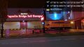
Behind Magnolia Bridge Self Storage
Participants
Plans
Thomcat was there in September of 2009; revisit tonight to verify
Expedition
On a whim, I stopped by the Magnolia Bridge self storage with my daughter to mark a geohash point and take pictures. I reached the spot - outside the building - though the GPS is not easy to read.
Photo was taken with my Canon Powershot, so EXIF has no GPS data.
This may be the oldest Ninja expedition ever found - 8 years, 2 months and 23 days!
Tracklog
Photos
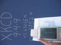
GPS - attempt #1

GPS - attempt #2
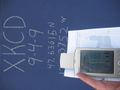
GPS - attempt #3

Geohasher!
Out front @47.6364,-122.3762

Geohashrr @47.6362,-122.3751


