Difference between revisions of "2018-03-16 50 11"
imported>Jens (Created page with "{{meetup graticule | lat=50 | lon=11 | date=2018-03-16 }} __NOTOC__ == Location == == Participants == * Juja == Expedition == It's me, Jens. I am wri...") |
imported>FippeBot m (Location) |
||
| (7 intermediate revisions by 2 users not shown) | |||
| Line 7: | Line 7: | ||
__NOTOC__ | __NOTOC__ | ||
== Location == | == Location == | ||
| + | In the snowy forest near Burgrabis/Luftschiff, Thuringia. | ||
| + | == Participants == | ||
| + | * [[user:Paintedhell|Juja]] and Knüppelschaf | ||
| + | |||
| + | == Presumed Expedition == | ||
| + | ''This section is here because of some miscommunication, I was just joking when I told Jens he had to write the report for me but because he is such a good friend he did it right away and that's what he wrote:'' | ||
| + | |||
| + | It's me, [[User:Jens|Jens]]. I am writing this report about the tour to yesterday's hashpoint, because I have not been there. I did not start just at the end of work in the short break until I wanted to meet with friends an the evening. So I did not have to climb up the hill on my good old bike. I could not ride on it through the falling snow half the way up and didn't have to push it the other half, just because the chain jumped off the chainwheel. I also did not have to wade through the mud around the point to get my shoes and trousers as dirty as possible. All these things did not happen … to me … but to Juja. | ||
| + | |||
| + | Unfortunately she meet with friends just after the hashtour too, then went to sleep and directly started into vacation. So no time was left to tell world that she has been there. So I do it for her now. The pictures will follow when Juja is back. | ||
| − | |||
| − | |||
== Expedition == | == Expedition == | ||
| + | This Geohash point was clearly from the Too-close-to-miss-section, but the other thing about Geohashing is that you have to go on the right day, no matter what the weather or your plans look like. The weather let me choose between heavy rain in the morning and light but steady snowfall in the evening, and my plans were, according to this, to use the small "WOP" between work and play to go on a snowy cycling adventure to today's point. | ||
| + | |||
| + | Sadly, the Ogre has become rather sick in the last few weeks of this winter, the shifters did not work reliably, the chain is worn down, so I wasn't sure how much gears I could use for my way uphill. Given that risk of course none of the other Jena Geohashers would accompany me, so I went alone, I went slowly, and sometimes I really had to push my little bike, but still we made it to the top of the hill and from there on through the snow to the Geohash point. Found it without problems but passed on the 0m-dance because the signal was drifting quite a lot in the forest, then mounted the little bike again and carefully descended, now with a frozen shifter (at least the problems vary so I won't get bored). Arrived right on time at [[User:Manu|Manu's]] and [[User:Reinhard|Reinhard's]] house where the food was already prepared and I could finally unfreeze, yay. | ||
| − | + | == Photos == | |
| − | + | {{gallery|width=200|height=200|lines=2 | |
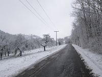
| + | |Image:180316_50_11_1.jpg|Cycling up to Steinkreuz. | ||
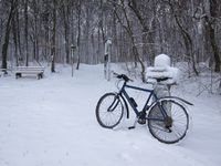
| + | |Image:180316_50_11_2.jpg|Little Ogre did it. | ||
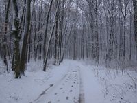
| + | |Image:180316_50_11_3.jpg|Way to the Geohash (have there been two hashers already?) | ||
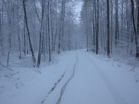
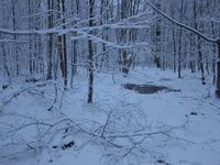
| + | |Image:180316_50_11_4.jpg|Arriving near the Geohash (I made the only track). | ||
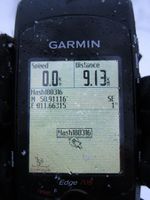
| + | |Image:180316_50_11_5.jpg|Point reached! | ||
| + | |Image:180316_50_11_6.jpg|View from the Geohash. | ||
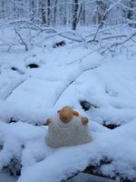
| + | |Image:180316_50_11_7.jpg|Knüppelschaf enjoying the weather. | ||
| + | |Image:180316_50_11_8.jpg|Ogre waiting for me near yet another important-looking stone. | ||
| + | }} | ||
[[Category:Expeditions]] | [[Category:Expeditions]] | ||
| + | [[Category:Expeditions with photos]] | ||
[[Category:Coordinates reached]] | [[Category:Coordinates reached]] | ||
| + | {{location|DE|TH|SHK}} | ||
Latest revision as of 03:24, 16 August 2019
| Fri 16 Mar 2018 in 50,11: 50.9111598, 11.6631540 geohashing.info google osm bing/os kml crox |
Location
In the snowy forest near Burgrabis/Luftschiff, Thuringia.
Participants
- Juja and Knüppelschaf
Presumed Expedition
This section is here because of some miscommunication, I was just joking when I told Jens he had to write the report for me but because he is such a good friend he did it right away and that's what he wrote:
It's me, Jens. I am writing this report about the tour to yesterday's hashpoint, because I have not been there. I did not start just at the end of work in the short break until I wanted to meet with friends an the evening. So I did not have to climb up the hill on my good old bike. I could not ride on it through the falling snow half the way up and didn't have to push it the other half, just because the chain jumped off the chainwheel. I also did not have to wade through the mud around the point to get my shoes and trousers as dirty as possible. All these things did not happen … to me … but to Juja.
Unfortunately she meet with friends just after the hashtour too, then went to sleep and directly started into vacation. So no time was left to tell world that she has been there. So I do it for her now. The pictures will follow when Juja is back.
Expedition
This Geohash point was clearly from the Too-close-to-miss-section, but the other thing about Geohashing is that you have to go on the right day, no matter what the weather or your plans look like. The weather let me choose between heavy rain in the morning and light but steady snowfall in the evening, and my plans were, according to this, to use the small "WOP" between work and play to go on a snowy cycling adventure to today's point.
Sadly, the Ogre has become rather sick in the last few weeks of this winter, the shifters did not work reliably, the chain is worn down, so I wasn't sure how much gears I could use for my way uphill. Given that risk of course none of the other Jena Geohashers would accompany me, so I went alone, I went slowly, and sometimes I really had to push my little bike, but still we made it to the top of the hill and from there on through the snow to the Geohash point. Found it without problems but passed on the 0m-dance because the signal was drifting quite a lot in the forest, then mounted the little bike again and carefully descended, now with a frozen shifter (at least the problems vary so I won't get bored). Arrived right on time at Manu's and Reinhard's house where the food was already prepared and I could finally unfreeze, yay.
Photos
|
