Difference between revisions of "2018-04-29 51 9"
From Geohashing
imported>GeorgDerReisende (new report) |
imported>FippeBot m (Location) |
||
| (One intermediate revision by one other user not shown) | |||
| Line 1: | Line 1: | ||
| − | |||
| − | |||
| − | |||
| − | |||
| − | |||
| − | |||
| − | |||
| − | |||
| − | |||
| − | |||
{{meetup graticule | {{meetup graticule | ||
| lat=51 | | lat=51 | ||
| Line 19: | Line 9: | ||
== Location == | == Location == | ||
| − | + | ||
| + | The hash lay in a field south of Baunatal-Großenritte. | ||
== Participants == | == Participants == | ||
| − | + | ||
| − | + | [[User:GeorgDerReisende|GeorgDerReisende]] | |
== Plans == | == Plans == | ||
| − | + | ||
| + | Travelling by tram and walking. | ||
== Expedition == | == Expedition == | ||
| − | |||
| − | + | Easy. Took trams 3 and 5, and walked. | |
| − | |||
== Photos == | == Photos == | ||
| − | |||
| − | |||
| − | |||
<gallery perrow="5"> | <gallery perrow="5"> | ||
| + | Image:2018-04-29 51 9 GeorgDerReisende 8217.jpg | there in the field | ||
| + | Image:2018-04-29 51 9 GeorgDerReisende 8218.jpg | took the right tractor lane | ||
| + | Image:2018-04-29 51 9 GeorgDerReisende 8220.jpg | three meters not to go | ||
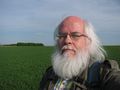
| + | Image:2018-04-29 51 9 GeorgDerReisende 8221.jpg | proof | ||
| + | Image:2018-04-29 51 9 GeorgDerReisende 8222.jpg | the north | ||
| + | Image:2018-04-29 51 9 GeorgDerReisende 8223.jpg | the east | ||
| + | Image:2018-04-29 51 9 GeorgDerReisende 8224.jpg | the south | ||
| + | Image:2018-04-29 51 9 GeorgDerReisende 8225.jpg | the west | ||
| + | Image:2018-04-29 51 9 GeorgDerReisende 8226.jpg | the geohasher | ||
</gallery> | </gallery> | ||
| Line 45: | Line 41: | ||
<!-- Add any achievement ribbons you earned below, or remove this section --> | <!-- Add any achievement ribbons you earned below, or remove this section --> | ||
| − | + | {{Easy_geohash | latitude = 51 | longitude = 9 | date = 2018-04-29 | name = GeorgDerReisende }} | |
| − | |||
| − | |||
| − | + | [[Category:Expeditions]] | |
| − | + | [[Category:Expeditions with photos]] | |
| − | |||
| − | |||
| − | |||
| − | |||
| − | |||
| − | |||
| − | |||
| − | |||
| − | |||
| − | |||
| − | |||
| − | |||
| − | |||
| − | |||
[[Category:Coordinates reached]] | [[Category:Coordinates reached]] | ||
| − | + | {{location|DE|HE|KS}} | |
| − | |||
| − | |||
| − | |||
| − | |||
| − | |||
| − | |||
| − | |||
| − | |||
| − | |||
| − | |||
| − | |||
| − | |||
| − | |||
| − | |||
| − | |||
| − | |||
| − | |||
Latest revision as of 03:35, 16 August 2019
| Sun 29 Apr 2018 in 51,9: 51.2417802, 9.3940846 geohashing.info google osm bing/os kml crox |
Location
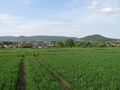
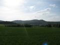
The hash lay in a field south of Baunatal-Großenritte.
Participants
Plans
Travelling by tram and walking.
Expedition
Easy. Took trams 3 and 5, and walked.
Photos
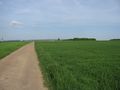
there in the field
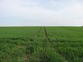
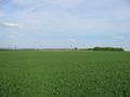
took the right tractor lane
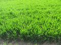
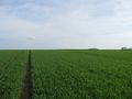
three meters not to go
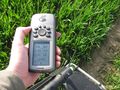
proof
the north
the east
the south
the west
the geohasher


Achievements
GeorgDerReisende has visited an Easy Geohash
|