Difference between revisions of "2018-07-25 47 -122"
imported>Thomcat ([live picture]Geohasher [http://www.openstreetmap.org/?lat=47.73988120&lon=-122.25440840&zoom=16&layers=B000FTF @47.7399,-122.2544]) |
imported>FippeBot m (Location) |
||
| (2 intermediate revisions by one other user not shown) | |||
| Line 18: | Line 18: | ||
== Expedition == | == Expedition == | ||
| − | + | Spent my lunch driving to and from this location, which is not far from the office really. Neighborhood was easily found; the point was just off the street. Stopped at a nearby elementary school briefly, then continued on my way. | |
| + | |||
| + | This spot is achievable from the Burke Gilman trail also, which is to say by bike from most of the north end of the city - but it is up a solid hill from the trail proper. No bike with me today, so that wasn't an option - plus it's durn hot out today! | ||
| + | |||
| + | What sort of a point will tomorrow bring? My guess is a damp one. | ||
== Tracklog == | == Tracklog == | ||
| Line 34: | Line 38: | ||
Image:2018-07-25_47_-122_thomcat_1532544975986.jpg|Geohasher [http://www.openstreetmap.org/?lat=47.73988120&lon=-122.25440840&zoom=16&layers=B000FTF @47.7399,-122.2544] | Image:2018-07-25_47_-122_thomcat_1532544975986.jpg|Geohasher [http://www.openstreetmap.org/?lat=47.73988120&lon=-122.25440840&zoom=16&layers=B000FTF @47.7399,-122.2544] | ||
| + | |||
| + | Image:2018-07-25_47_-122_thomcat_1532545114314.jpg|Arrowhead Elem [http://www.openstreetmap.org/?lat=47.73807790&lon=-122.25131760&zoom=16&layers=B000FTF @47.7381,-122.2513] | ||
</gallery> | </gallery> | ||
| Line 50: | Line 56: | ||
--> | --> | ||
| − | |||
| − | |||
| − | |||
[[Category:Expeditions]] | [[Category:Expeditions]] | ||
[[Category:Expeditions with photos]] | [[Category:Expeditions with photos]] | ||
[[Category:Coordinates reached]] | [[Category:Coordinates reached]] | ||
| − | + | {{location|US|WA|KN}} | |
| − | |||
| − | |||
| − | |||
| − | |||
| − | |||
| − | |||
| − | |||
| − | |||
| − | |||
| − | |||
Latest revision as of 03:53, 16 August 2019
| Wed 25 Jul 2018 in Seattle: 47.7398652, -122.2544036 geohashing.info google osm bing/os kml crox |
Location
Just of 154th street, south of Inglemoor golf course.
Participants
Plans
Stop by early afternoon with sidewalk chalk.
Expedition
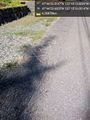
Spent my lunch driving to and from this location, which is not far from the office really. Neighborhood was easily found; the point was just off the street. Stopped at a nearby elementary school briefly, then continued on my way.
This spot is achievable from the Burke Gilman trail also, which is to say by bike from most of the north end of the city - but it is up a solid hill from the trail proper. No bike with me today, so that wasn't an option - plus it's durn hot out today!
What sort of a point will tomorrow bring? My guess is a damp one.
Tracklog
Photos
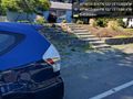
Near @47.7399,-122.2544
Mark @47.7399,-122.2545

Geohasher @47.7399,-122.2544
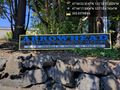
Arrowhead Elem @47.7381,-122.2513


