Difference between revisions of "2018-08-10 47 11"
From Geohashing
imported>Claralucia9 ([live picture]Panorama) |
m (Username changed) |
||
| (8 intermediate revisions by 3 users not shown) | |||
| Line 19: | Line 19: | ||
== Location == | == Location == | ||
| − | + | In a meadow in Kleinkarolinenfeld, close to Aying, south of Munich | |
== Participants == | == Participants == | ||
| − | + | [[User:Clearlucid9|Claralucia9]] ([[User talk:Clearlucid9|talk]]) | |
| − | |||
== Plans == | == Plans == | ||
| Line 29: | Line 28: | ||
== Expedition == | == Expedition == | ||
| − | + | Friday afternoon an a slightly rainy day. I had to drive my daughter to a friends house and took the occasion to drive a little further to reach this hash. from the satellite photo I thought it would be in the middle of a cornfield, but as it turned out this year it was just a meadow - so walking to the spot was no trouble. Without any trees impacting on the GPS reception I got within less than a meter from the coordinates. | |
| + | Nothing spectacular, but I was happy to have done another hash - haven't had the occasion in a while... | ||
== Tracklog == | == Tracklog == | ||
| Line 35: | Line 35: | ||
== Photos == | == Photos == | ||
| − | + | ||
| − | |||
| − | |||
<gallery perrow="5"> | <gallery perrow="5"> | ||
| − | |||
| − | |||
Image:2018-08-10_47_11_Claralucia9_1533921291208.jpg|As close as I could get | Image:2018-08-10_47_11_Claralucia9_1533921291208.jpg|As close as I could get | ||
| Line 47: | Line 43: | ||
Image:2018-08-10_47_11_Claralucia9_1533921359116.jpg|Panorama | Image:2018-08-10_47_11_Claralucia9_1533921359116.jpg|Panorama | ||
| + | |||
| + | Image:2018-08-10_47_11_Claralucia9_1533922697269.jpg|Logphoto | ||
</gallery> | </gallery> | ||
| Line 53: | Line 51: | ||
<!-- Add any achievement ribbons you earned below, or remove this section --> | <!-- Add any achievement ribbons you earned below, or remove this section --> | ||
| − | |||
| − | |||
| − | |||
| − | |||
| − | |||
| − | |||
| − | |||
| − | |||
| − | |||
| − | |||
| − | |||
| − | |||
| − | |||
| − | |||
[[Category:Expeditions]] | [[Category:Expeditions]] | ||
| − | |||
[[Category:Expeditions with photos]] | [[Category:Expeditions with photos]] | ||
| − | |||
| − | |||
| − | |||
| − | |||
| − | |||
[[Category:Coordinates reached]] | [[Category:Coordinates reached]] | ||
| − | + | {{location|DE|BY|M}} | |
| − | |||
| − | |||
| − | |||
| − | |||
| − | |||
| − | |||
| − | |||
| − | |||
| − | |||
| − | |||
| − | |||
| − | |||
| − | |||
| − | |||
| − | |||
| − | |||
| − | |||
Latest revision as of 12:36, 31 October 2021
| Fri 10 Aug 2018 in 47,11: 47.9492822, 11.7493219 geohashing.info google osm bing/os kml crox |
Location
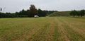
In a meadow in Kleinkarolinenfeld, close to Aying, south of Munich
Participants
Plans
Expedition
Friday afternoon an a slightly rainy day. I had to drive my daughter to a friends house and took the occasion to drive a little further to reach this hash. from the satellite photo I thought it would be in the middle of a cornfield, but as it turned out this year it was just a meadow - so walking to the spot was no trouble. Without any trees impacting on the GPS reception I got within less than a meter from the coordinates. Nothing spectacular, but I was happy to have done another hash - haven't had the occasion in a while...
Tracklog
Photos

As close as I could get
View from hash
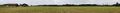
Panorama
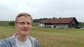
Logphoto


