Difference between revisions of "2018-08-09 31 35"
imported>Yosef (Created page with "{{subst:Expedition |lat = 31 |lon = 35 |date = 2018-08-09 }}") |
m (Location) |
||
| (13 intermediate revisions by 2 users not shown) | |||
| Line 20: | Line 20: | ||
== Location == | == Location == | ||
<!-- where you've surveyed the hash to be --> | <!-- where you've surveyed the hash to be --> | ||
| + | The desert near Mizpeh Yeriho, Binyamin, Israel. The town's name means Jericho Lookout, as in you get a very full view of Jericho down below. | ||
== Participants == | == Participants == | ||
<!-- who attended: If you link to your wiki user name in this section, your expedition will be picked up by the various statistics generated for geohashing. You may use three tildes ~ as a shortcut to automatically insert the user signature of the account you are editing with. | <!-- who attended: If you link to your wiki user name in this section, your expedition will be picked up by the various statistics generated for geohashing. You may use three tildes ~ as a shortcut to automatically insert the user signature of the account you are editing with. | ||
--> | --> | ||
| + | [[User:Yosef|Yosef]] ([[User talk:Yosef|talk]]) | ||
== Plans == | == Plans == | ||
<!-- what were the original plans --> | <!-- what were the original plans --> | ||
| + | One of the few times that I was ready to actually burn gasoline to go to a hashpoint. I drove there after work. | ||
== Expedition == | == Expedition == | ||
<!-- how it all turned out. your narrative goes here. --> | <!-- how it all turned out. your narrative goes here. --> | ||
| + | This one was a ton of fun. It was again one of the few times that I drove to directly to a hash and not as a detour because I knew it would be so cool. I stopped in the village as planned and bought a nice large bottle of juice. I drank about a third of it and then ran through the village to the lookout. I was planning on running north and then seeing if there was a cut-through to the east but it all looked like steep cliffs. Instead I continued and descended from the lookout on the northwest slope, which actually had a trail, into the desert. From there I followed the slopes to the hashpoint. There was sort of a trail. Everything was quite steep. I hash danced on a slope and then walked and ran back to town. From there I drove back to my home and picked up four hitchhikers on the way. | ||
| + | |||
| + | == Israel Area C == | ||
| + | The area where I was Israel Area C. There is an attempt on this site to call this area [[Palestine]]. In the discussion on Palestine, I explain why that cannot be. Not only it is not currently Palestine it hasn't ever been independently Palestine. I encourage people to change the Palestine site to a more appropriate definition. Please read the discussion page for more detail. | ||
== Tracklog == | == Tracklog == | ||
| Line 39: | Line 46: | ||
--> | --> | ||
<gallery perrow="5"> | <gallery perrow="5"> | ||
| + | Image:20180809 180906.jpg | pic | ||
| + | Image:20180809 174130.jpg | pic | ||
| + | Image:20180809 174124.jpg | pic | ||
| + | Image:20180809 170011.jpg | pic | ||
| + | Image:20180809 165345.jpg | pic | ||
| + | |||
| + | Image:20180809 165322.jpg | the town in construction not next to the hash | ||
| + | Image:20180809 180818.jpg | selfie | ||
| + | Image:Screenshot 2018-08-09-18-07-46.png | proof | ||
| + | Image:Screenshot 2018-08-09-18-03-59.png | proof | ||
| + | Image:Screenshot 2018-08-09-18-01-05.png | proof | ||
</gallery> | </gallery> | ||
| Line 45: | Line 63: | ||
<!-- Add any achievement ribbons you earned below, or remove this section --> | <!-- Add any achievement ribbons you earned below, or remove this section --> | ||
| − | |||
| − | |||
| − | |||
| − | |||
| − | |||
| − | |||
| − | |||
| − | |||
| − | |||
| − | |||
| − | |||
| − | |||
| − | |||
| − | |||
[[Category:Expeditions]] | [[Category:Expeditions]] | ||
| − | |||
[[Category:Expeditions with photos]] | [[Category:Expeditions with photos]] | ||
| − | |||
| − | |||
| − | |||
| − | |||
| − | |||
[[Category:Coordinates reached]] | [[Category:Coordinates reached]] | ||
| − | + | {{location|IL|YS}} | |
| − | |||
| − | |||
| − | |||
| − | |||
| − | |||
| − | |||
| − | |||
| − | |||
| − | |||
| − | |||
| − | |||
| − | |||
| − | |||
| − | |||
| − | |||
| − | |||
| − | |||
Latest revision as of 16:33, 26 February 2020
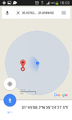
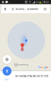
| Thu 9 Aug 2018 in 31,35: 31.8189454, 35.4076372 geohashing.info google osm bing/os kml crox |
Location
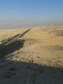
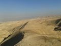
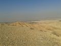
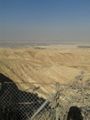
The desert near Mizpeh Yeriho, Binyamin, Israel. The town's name means Jericho Lookout, as in you get a very full view of Jericho down below.
Participants
Plans
One of the few times that I was ready to actually burn gasoline to go to a hashpoint. I drove there after work.
Expedition
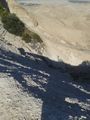
This one was a ton of fun. It was again one of the few times that I drove to directly to a hash and not as a detour because I knew it would be so cool. I stopped in the village as planned and bought a nice large bottle of juice. I drank about a third of it and then ran through the village to the lookout. I was planning on running north and then seeing if there was a cut-through to the east but it all looked like steep cliffs. Instead I continued and descended from the lookout on the northwest slope, which actually had a trail, into the desert. From there I followed the slopes to the hashpoint. There was sort of a trail. Everything was quite steep. I hash danced on a slope and then walked and ran back to town. From there I drove back to my home and picked up four hitchhikers on the way.
Israel Area C
The area where I was Israel Area C. There is an attempt on this site to call this area Palestine. In the discussion on Palestine, I explain why that cannot be. Not only it is not currently Palestine it hasn't ever been independently Palestine. I encourage people to change the Palestine site to a more appropriate definition. Please read the discussion page for more detail.
Tracklog
Photos
pic
pic
pic
pic
pic
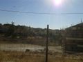
the town in construction not next to the hash
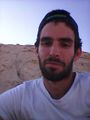
selfie
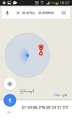
proof
proof
proof


