Difference between revisions of "2018-08-26 45 -119"
imported>Michael5000 (creating page) |
Michael5000 (talk | contribs) (→Achievements) |
||
| (15 intermediate revisions by 3 users not shown) | |||
| Line 1: | Line 1: | ||
| − | |||
| − | |||
| − | |||
| − | |||
| − | |||
| − | |||
| − | |||
| − | |||
| − | |||
{{meetup graticule | {{meetup graticule | ||
| lat=45 | | lat=45 | ||
| Line 14: | Line 5: | ||
| date=2018-08-26 | | date=2018-08-26 | ||
}} | }} | ||
| − | |||
| − | |||
__NOTOC__ | __NOTOC__ | ||
== Location == | == Location == | ||
| − | + | ||
| + | In somebody's driveway on 3rd Street in Umatilla, Oregon, underneath a pile of stuff left over from a moving sale. | ||
== Participants == | == Participants == | ||
| − | |||
| − | |||
| − | + | * [[user:Michael5000|Michael5000]] | |
| − | |||
== Expedition == | == Expedition == | ||
| − | |||
| − | + | I was heading back towards Portland, and thought I'd check the hashpoints just for auld lang syne. And by gum, there was a perfectly accessible hashpoint, hardly out of the way at all. | |
| − | + | ||
| + | The house at the hashpoint had had a moving sale over the weekend, but it was over by the time I got there. There was a pile of stuff directly on the hashpoint, apparently the stuff that they hadn't been able to sell. | ||
| + | |||
| + | I had forgotten how much fun it is to approach a hashpoint! Also, what a pain in the rear it is to edit a report in this wiki! | ||
== Photos == | == Photos == | ||
| Line 39: | Line 28: | ||
--> | --> | ||
<gallery perrow="5"> | <gallery perrow="5"> | ||
| + | File:2018-08-26 45 -119 signs.jpg|I was too late for the moving sale, and I didn't see any slow children. | ||
| + | File:2018-08-26 45 -119 site.jpg|The hashpoint was buried under that pile of stuff by the trailer. I didn't dig down to it. | ||
| + | File:2018-08-26 45 -119 pile.jpg|I guess this is the stuff that didn't get bought at the moving sale. | ||
</gallery> | </gallery> | ||
== Achievements == | == Achievements == | ||
{{#vardefine:ribbonwidth|800px}} | {{#vardefine:ribbonwidth|800px}} | ||
| − | + | {{location|US|OR|UM}} | |
| − | |||
| − | |||
| − | |||
| − | |||
| − | + | * Land Geohash | |
| + | * My first expedition to the Hermiston graticule | ||
| − | |||
| − | |||
| − | |||
| − | |||
| − | |||
| − | |||
| − | |||
| − | |||
[[Category:Expeditions]] | [[Category:Expeditions]] | ||
| − | |||
[[Category:Expeditions with photos]] | [[Category:Expeditions with photos]] | ||
| − | |||
| − | |||
| − | |||
| − | |||
| − | |||
[[Category:Coordinates reached]] | [[Category:Coordinates reached]] | ||
| − | |||
| − | |||
| − | |||
| − | |||
| − | |||
| − | |||
| − | |||
| − | |||
| − | |||
| − | |||
| − | |||
| − | |||
| − | |||
| − | |||
| − | |||
| − | |||
| − | |||
| − | |||
Latest revision as of 18:20, 28 May 2022
| Sun 26 Aug 2018 in 45,-119: 45.9215015, -119.3355937 geohashing.info google osm bing/os kml crox |
Location
In somebody's driveway on 3rd Street in Umatilla, Oregon, underneath a pile of stuff left over from a moving sale.
Participants
Expedition
I was heading back towards Portland, and thought I'd check the hashpoints just for auld lang syne. And by gum, there was a perfectly accessible hashpoint, hardly out of the way at all.
The house at the hashpoint had had a moving sale over the weekend, but it was over by the time I got there. There was a pile of stuff directly on the hashpoint, apparently the stuff that they hadn't been able to sell.
I had forgotten how much fun it is to approach a hashpoint! Also, what a pain in the rear it is to edit a report in this wiki!
Photos

I was too late for the moving sale, and I didn't see any slow children.
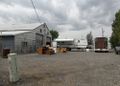
The hashpoint was buried under that pile of stuff by the trailer. I didn't dig down to it.
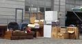
I guess this is the stuff that didn't get bought at the moving sale.


Achievements
- Land Geohash
- My first expedition to the Hermiston graticule