Difference between revisions of "2018-09-17 -37 144"
imported>Felix Dance m (→Participants) |
m (More specific location) |
||
| (5 intermediate revisions by 3 users not shown) | |||
| Line 1: | Line 1: | ||
| − | |||
| − | |||
| − | |||
| − | |||
| − | |||
| − | |||
| − | |||
| − | |||
| − | |||
| − | |||
{{meetup graticule | {{meetup graticule | ||
| lat=-37 | | lat=-37 | ||
| Line 14: | Line 4: | ||
| date=2018-09-17 | | date=2018-09-17 | ||
}} | }} | ||
| − | |||
| − | |||
| − | |||
== Location == | == Location == | ||
| Line 22: | Line 9: | ||
== Participants == | == Participants == | ||
| − | *[[Felix Dance|Felix Dance]] | + | *[[User:Felix Dance|Felix Dance]] |
| − | == | + | == Expedition == |
| − | + | Still smarting from my failure on Friday, this geohash presented the opportunity to get my game back with a success - right in the middle of a public park just off the Federation bike trail. | |
| − | + | After faffing about at home I saw a train on my app departing shortly for Hoppers Crossing so I left to take it. | |
| − | + | ||
| + | But when the train reached the next station, I realised I'd misread my public transport app and I'd have to change trains here - and it was a long wait for my connection. | ||
| + | |||
| + | I tried to see if my dad was interested in a ride from here, since he'd said he was at a loose end. So, inspired by my own idea, I decided to ride the rest of the way myself anyway. | ||
| + | |||
| + | Stopping only to buy brewing supplies in Yarraville, and tasting some of their delicious beer, I hurtled along the trucky Francis Street and onto the Federation Bike Trail, which tours the outer western industrial suburbs. | ||
| + | |||
| + | Along the way I encountered an algal swamp, and a guy trying to pump it up, but it shallow enough to ride through. | ||
| + | |||
| + | Later I came across some road construction work that I'd been responsible for bidding on with a construction company I'd worked with last year, which was interesting to see. | ||
| + | |||
| + | Finally, after passing under a century-old, brick aqueduct I arrived at the hash-park - a windy, open grassland with a playground and a small stand of trees (where the hash was). I took photos and bolted. | ||
| + | |||
| + | On the way home, I headed north for the inter-city V-Line train service, which took me back to Footscray Station, from whence I rode home. | ||
== Tracklog == | == Tracklog == | ||
| − | + | [https://goo.gl/maps/Ho2Uk82s1Pv Here] is the route of my cycling trip. | |
== Photos == | == Photos == | ||
| Line 49: | Line 49: | ||
Image:2018-09-17_-37_144_Felix Dance_1537161195320.jpg|GPS proof | Image:2018-09-17_-37_144_Felix Dance_1537161195320.jpg|GPS proof | ||
| − | Image:2018-09-17_-37_144_Felix Dance_1537161226763.jpg| | + | Image:2018-09-17_-37_144_Felix Dance_1537161226763.jpg|Aqueduct near the hash |
Image:2018-09-17_-37_144_Felix Dance_1537161274633.jpg|Swamp obstacle on the way to the hash | Image:2018-09-17_-37_144_Felix Dance_1537161274633.jpg|Swamp obstacle on the way to the hash | ||
| Line 60: | Line 60: | ||
<!-- Add any achievement ribbons you earned below, or remove this section --> | <!-- Add any achievement ribbons you earned below, or remove this section --> | ||
| − | |||
| − | |||
| − | |||
| − | |||
| − | |||
| − | |||
| − | |||
| − | |||
| − | |||
| − | |||
| − | |||
| − | |||
| − | |||
| − | |||
[[Category:Expeditions]] | [[Category:Expeditions]] | ||
| − | |||
[[Category:Expeditions with photos]] | [[Category:Expeditions with photos]] | ||
| − | |||
| − | |||
| − | |||
| − | |||
| − | |||
[[Category:Coordinates reached]] | [[Category:Coordinates reached]] | ||
| − | + | {{location|AU|VIC|WY}} | |
| − | |||
| − | |||
| − | |||
| − | |||
| − | |||
| − | |||
| − | |||
| − | |||
| − | |||
| − | |||
| − | |||
| − | |||
| − | |||
| − | |||
| − | |||
| − | |||
| − | |||
Latest revision as of 12:55, 1 August 2020
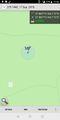
| Mon 17 Sep 2018 in -37,144: -37.8667616, 144.7154294 geohashing.info google osm bing/os kml crox |
Location
In a park in Hoppers Crossing
Participants
Expedition
Still smarting from my failure on Friday, this geohash presented the opportunity to get my game back with a success - right in the middle of a public park just off the Federation bike trail.
After faffing about at home I saw a train on my app departing shortly for Hoppers Crossing so I left to take it.
But when the train reached the next station, I realised I'd misread my public transport app and I'd have to change trains here - and it was a long wait for my connection.
I tried to see if my dad was interested in a ride from here, since he'd said he was at a loose end. So, inspired by my own idea, I decided to ride the rest of the way myself anyway.
Stopping only to buy brewing supplies in Yarraville, and tasting some of their delicious beer, I hurtled along the trucky Francis Street and onto the Federation Bike Trail, which tours the outer western industrial suburbs.
Along the way I encountered an algal swamp, and a guy trying to pump it up, but it shallow enough to ride through.
Later I came across some road construction work that I'd been responsible for bidding on with a construction company I'd worked with last year, which was interesting to see.
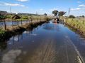
Finally, after passing under a century-old, brick aqueduct I arrived at the hash-park - a windy, open grassland with a playground and a small stand of trees (where the hash was). I took photos and bolted.
On the way home, I headed north for the inter-city V-Line train service, which took me back to Footscray Station, from whence I rode home.
Tracklog
Here is the route of my cycling trip.
Photos
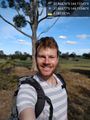
Geohash success! @-37.8668,144.7155
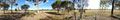
Panorama!
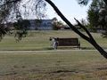
My bike near the hash
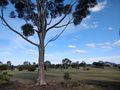
Hast tree
GPS proof

Aqueduct near the hash
Swamp obstacle on the way to the hash
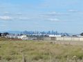
View of Melbourne flanked by the Dandenongs on the train ride home


