Difference between revisions of "2018-12-24 43 -121"
From Geohashing
imported>Frogman ([live picture]GPS) |
imported>FippeBot m (Location) |
||
| (2 intermediate revisions by one other user not shown) | |||
| Line 1: | Line 1: | ||
| + | [[Image:{{{image|2018-12-24_43_-121_frogman_1545693165074.jpg}}}|thumb|left]] | ||
| − | |||
| − | |||
| − | |||
| − | |||
| − | |||
| − | |||
| − | |||
| − | |||
| − | |||
{{meetup graticule | {{meetup graticule | ||
| lat=43 | | lat=43 | ||
| Line 15: | Line 7: | ||
}} | }} | ||
| − | |||
__NOTOC__ | __NOTOC__ | ||
== Location == | == Location == | ||
| − | + | Right in the middle of Forest Service Road 45, just west of Sunriver. | |
== Participants == | == Participants == | ||
| − | + | * [[User:Frogman|Frogman]] | |
| − | + | * [[User:Benture|Benture]] | |
| − | + | * Daisy | |
| − | |||
| − | |||
== Expedition == | == Expedition == | ||
| − | + | We noticed that this was a very easy hashpoint to reach from where we were, so we got into the truck to take a quick swing by. Unfortunately, the truck didn't start, so we needed to wait for my mother to get back home with the other car that could handle the weather. | |
| − | + | Once she did, we headed out. The road was very slick, and we skidded a bit on back roads. The hashpoint was, as expected, easy to reach by car as it was in the middle of a road. We tried to find a place to pull out to reach the hashpoint on foot, but side roads were inaccessible and the road was heavy with traffic from Mt. Bachelor anyway so we just headed home. | |
| − | |||
== Photos == | == Photos == | ||
| Line 47: | Line 35: | ||
Image:2018-12-24_43_-121_frogman_1545693213300.jpg|GPS | Image:2018-12-24_43_-121_frogman_1545693213300.jpg|GPS | ||
| + | |||
| + | Image:2018-12-24_43_-121_frogman_1545693221798.jpg|Grins | ||
</gallery> | </gallery> | ||
| Line 53: | Line 43: | ||
<!-- Add any achievement ribbons you earned below, or remove this section --> | <!-- Add any achievement ribbons you earned below, or remove this section --> | ||
| − | + | {{Speed racer | |
| − | |||
| − | |||
| − | + | | latitude = 43 | |
| + | | longitude = -121 | ||
| + | | date = 2018-12-24 | ||
| + | | name = [[User:Frogman|Frogman]], [[User:Benture|Benture]], and Daisy | ||
| + | | image = 2018-12-24_43_-121_frogman_1545693165074.jpg | ||
| + | | speed = 55mph | ||
| − | + | }} | |
| − | |||
| − | |||
| − | |||
| − | |||
| − | |||
| − | |||
| − | |||
[[Category:Expeditions]] | [[Category:Expeditions]] | ||
| − | |||
[[Category:Expeditions with photos]] | [[Category:Expeditions with photos]] | ||
| − | |||
| − | |||
| − | |||
| − | |||
| − | |||
| − | |||
| − | |||
[[Category:Coordinates reached]] | [[Category:Coordinates reached]] | ||
| − | + | {{location|US|OR|DE}} | |
| − | |||
| − | |||
| − | |||
| − | |||
| − | |||
| − | |||
| − | |||
| − | |||
| − | |||
| − | |||
| − | |||
| − | |||
| − | |||
| − | |||
| − | |||
| − | |||
| − | |||
Latest revision as of 04:20, 16 August 2019
| Mon 24 Dec 2018 in 43,-121: 43.8639673, -121.5357197 geohashing.info google osm bing/os kml crox |
Location
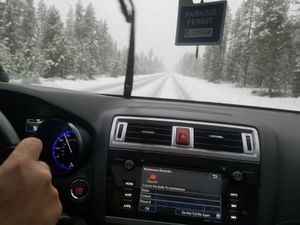
Right in the middle of Forest Service Road 45, just west of Sunriver.
Participants
Expedition
We noticed that this was a very easy hashpoint to reach from where we were, so we got into the truck to take a quick swing by. Unfortunately, the truck didn't start, so we needed to wait for my mother to get back home with the other car that could handle the weather.
Once she did, we headed out. The road was very slick, and we skidded a bit on back roads. The hashpoint was, as expected, easy to reach by car as it was in the middle of a road. We tried to find a place to pull out to reach the hashpoint on foot, but side roads were inaccessible and the road was heavy with traffic from Mt. Bachelor anyway so we just headed home.
Photos
Achievements
Frogman, Benture, and Daisy earned the Speed racer achievement
|


