Difference between revisions of "2018-12-31 51 0"
imported>Sourcerer m ([live picture] Proof [http://www.openstreetmap.org/?lat=51.96540713&lon=.59445798&zoom=16&layers=B000FTF @51.9654,.5945]) |
imported>FippeBot m (Location) |
||
| (3 intermediate revisions by one other user not shown) | |||
| Line 13: | Line 13: | ||
== Planning == | == Planning == | ||
| − | One of two spanning the new year midnight. ETA 23: | + | One of two spanning the new year midnight. ETA 23:00 - [[2018-12-31 51 0]] - [[2019-01-01 51 0]] |
This is only 5km in a straight line to the next hashpoint. | This is only 5km in a straight line to the next hashpoint. | ||
| Line 23: | Line 23: | ||
== Expedition == | == Expedition == | ||
| + | There was a parking bay in the village. The wider obvious footpath turned out to be a dead end. A much less obvious path led west off the road into woodland. The path headed south across a grassy meadow. The hashpoint was in this field and could be reached without crossing any additional gates or fences so this was an easy one. The 3G signal was working, just as well because I'd forgotten to program the coordinates before setting out. Coordinates reached 4 minutes ahead of schedule. | ||
== Photos == | == Photos == | ||
<gallery caption="Gallery" widths="200px" heights="200px" perrow="3"> | <gallery caption="Gallery" widths="200px" heights="200px" perrow="3"> | ||
| − | |||
Image:2018-12-31_51_0_Sourcerer_1546296664023.jpg | Proof [http://www.openstreetmap.org/?lat=51.96540713&lon=.59445798&zoom=16&layers=B000FTF @51.9654,.5945] | Image:2018-12-31_51_0_Sourcerer_1546296664023.jpg | Proof [http://www.openstreetmap.org/?lat=51.96540713&lon=.59445798&zoom=16&layers=B000FTF @51.9654,.5945] | ||
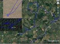
| + | Image:2019-01-01 Sourcerer.jpg | Track in Google Earth | ||
</gallery> | </gallery> | ||
| Line 35: | Line 36: | ||
| prev = 2018-12-30_51_1 | | prev = 2018-12-30_51_1 | ||
| curr = 2018-12-31_51_0 | | curr = 2018-12-31_51_0 | ||
| − | | next = 2019-01- | + | | next = 2019-01-01_51_0 |
| date = 2018-12-31 | | date = 2018-12-31 | ||
}} | }} | ||
| − | [[Category: | + | [[Category:Expeditions]] |
[[Category:Expeditions with photos]] | [[Category:Expeditions with photos]] | ||
| − | [[Category:Coordinates | + | [[Category:Coordinates reached]] |
| + | {{location|GB|ENG|ESS}} | ||
Latest revision as of 04:23, 16 August 2019
| Mon 31 Dec 2018 in London East: 51.9654271, 0.5944640 geohashing.info google osm bing/os kml crox |
Location
A mid field hashpoint near Sible Hedingham, Essex, UK.
Planning
One of two spanning the new year midnight. ETA 23:00 - 2018-12-31 51 0 - 2019-01-01 51 0
This is only 5km in a straight line to the next hashpoint.
Participants
Expedition
There was a parking bay in the village. The wider obvious footpath turned out to be a dead end. A much less obvious path led west off the road into woodland. The path headed south across a grassy meadow. The hashpoint was in this field and could be reached without crossing any additional gates or fences so this was an easy one. The 3G signal was working, just as well because I'd forgotten to program the coordinates before setting out. Coordinates reached 4 minutes ahead of schedule.
Photos
- Gallery
Proof @51.9654,.5945
Achievements
Expeditions and Plans
| 2018-12-31 | ||
|---|---|---|
| Rhinelander, Wisconsin | WausauBill | County Rd H, Deerbrook, WI (According to Google Maps) |
| Innsbruck, Austria | Claralucia9 | A meadow close to Altkirchen, South of Munich |
| London East, United Kingdom | Sourcerer | A mid field hashpoint near Sible Hedingham, Essex, UK. |
| Hannover, Germany | Fippe | located in a forest near Visselhövede. |
Sourcerer's Expedition Links
2018-12-30_51_1 - 2018-12-31_51_0 - 2019-01-01_51_0 - KML file download of Sourcerer's expeditions for use with Google Earth.

