Difference between revisions of "2019-01-09 49 8"
imported>Kellerkind m (Fix link) |
m |
||
| (2 intermediate revisions by 2 users not shown) | |||
| Line 50: | Line 50: | ||
| prev = 2019-01-01_51_0 | | prev = 2019-01-01_51_0 | ||
| curr = 2019-01-09_49_8 | | curr = 2019-01-09_49_8 | ||
| − | | next = 2019- | + | | next = 2019-02-13_51_0 |
| date = 2019-01-09 | | date = 2019-01-09 | ||
}} | }} | ||
| Line 57: | Line 57: | ||
[[Category:Expeditions with photos]] | [[Category:Expeditions with photos]] | ||
[[Category:Coordinates not reached]] | [[Category:Coordinates not reached]] | ||
| + | [[Category:Not reached - Time constraints]] | ||
| + | {{location|DE|BW|HD}} | ||
Latest revision as of 11:06, 27 March 2022
| Wed 9 Jan 2019 in Mannheim: 49.2827813, 8.6968347 geohashing.info google osm bing/os kml crox |
Location
Somewhere in the Mannheim graticule. Overfly the region.
Planning
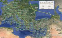
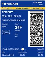
Fly from London, Stansted to Paphos, Cyprus visiting 50 graticules on the route. Hope to hit a hashpoint by chance.
Participants
Expedition - Fail
Why Mannheim? Well it recently became the most active graticule in the world by coordinates-reached - congratulations. And Sourcerer has been watching your activities with interest for several years. Hi everyone! And this report might be read by several geohashers. And I don't want to write 50 expedition reports.
Commercial flights can be boring but an expedition of 50 graticules at around 12 per hour passes the time quite nicely. In Mannheim, I passed 31 km north of the hashpoint between Wiesloch and Rauenberg.
The expedition failed but came close in several graticules. Canterbury, close to home, was the closest approach. I was under 5 hash units from the hashpoint. For an air geohash, a hash unit is 310 metres.
- 51 1 - 1.48 km - Screen grab not done
- 50 5 - 4.1 km
- 47 12 - 7.91 km
- 45 15 - 4.26 km
- 43 18 - 9.9 km
- 38 25 - 2.9 km
A year ago, on a similar flight, I was successful over 2018-01-31 43 19. I have guestimated that on this path there is between 13% and 25% chance of hitting a hashpoint.
I used my KML generator and Google Earth Desktop to get the main image with nearly 500 hashpoints. This only involved three download and file opening steps. Useful!
Photos
- Gallery
Achievements
Expeditions and Plans
| 2019-01-09 | ||
|---|---|---|
| Mannheim, Germany | Sourcerer | Somewhere in the Mannheim graticule. Overfly the region. |
| Uppsala, Sweden | Fractal | Between a small forest and a sort of lake, about an hour or two west of Sto... |
| Tampere, Finland | PJH FIN, Hermiina | Small residential area in Vesilahti, 4 km SE from municipality center and 2... |
Sourcerer's Expedition Links
2019-01-01_51_0 - 2019-01-09_49_8 - 2019-02-13_51_0 - KML file download of Sourcerer's expeditions for use with Google Earth.


