Difference between revisions of "2019-04-30 47 -122"
From Geohashing
imported>Thomcat |
imported>FippeBot m (Location) |
||
| Line 59: | Line 59: | ||
[[Category:Expeditions with photos]] | [[Category:Expeditions with photos]] | ||
[[Category:Coordinates reached]] | [[Category:Coordinates reached]] | ||
| + | {{location|US|WA|KN}} | ||
Latest revision as of 04:40, 16 August 2019
| Tue 30 Apr 2019 in Seattle: 47.7064923, -122.3015898 geohashing.info google osm bing/os kml crox |
Location
On Lake City Way, east of Northgate
Participants
Plans
Stop by on the way to work
Expedition
Been a while since a geohash was not in the water or on the peninsula. Happy to see one, I swung by first thing this morning to claim it.
On street view, it is between those two trees, in the rightmost lane if you are travelling northbound. I did see a little traffic, but had a chance to make a chalkmark on the approximate spot. GPS wandered a little, due to that tree.
Nearby is the neighborhood of Victory Heights, site of a recent expedition that failed to reach the point. Hoping tomorrow (birthday hash) is also reachable.
Tracklog
Photos
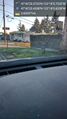
Parked @47.7065,-122.3016
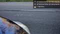
Spot @47.7065,-122.3016
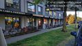
Businesses @47.7065,-122.3015

Geohasher @47.7065,-122.3016


