Difference between revisions of "2019-05-26 52 1"
imported>Sourcerer m ([live picture] Church. [http://www.openstreetmap.org/?lat=52.43626893&lon=1.36564672&zoom=16&layers=B000FTF @52.4363,1.3656]) |
imported>Sourcerer m (→Achievements) |
||
| (9 intermediate revisions by the same user not shown) | |||
| Line 1: | Line 1: | ||
| − | |||
| − | |||
| − | |||
| − | |||
| − | |||
| − | |||
| − | |||
| − | |||
| − | |||
| − | |||
{{meetup graticule | {{meetup graticule | ||
| lat=52 | | lat=52 | ||
| lon=1 | | lon=1 | ||
| date=2019-05-26 | | date=2019-05-26 | ||
| + | | graticule_name=Norwich | ||
| + | | graticule_link=Norwich, United Kingdom | ||
}} | }} | ||
| + | __NOTOC__ | ||
| + | == Location == | ||
| + | |||
| + | A field perimeter near Denton, Norfolk, UK. | ||
| − | + | == Planning == | |
| − | |||
| − | + | Go because it's so close to home. | |
| − | |||
== Participants == | == Participants == | ||
| − | |||
| − | |||
| − | + | * [[User:Sourcerer|Sourcerer]] | |
| − | |||
== Expedition == | == Expedition == | ||
| − | |||
| − | |||
| − | |||
| − | |||
| − | + | The parish church of Saint Mary the Virgin, Denton was the nearest landmark and there was a parking bay not far from the church. At the north end of the cemetery, there was a gate into a meadow with an obvious track leading the right way. There were no "keep out" signs so through I went. About 150 metres later, there was the hashpoint right at the field edge. Access to the road was blocked by a deep drainage ditch so the approach via the church was optimal. | |
| − | |||
| − | |||
| − | |||
| − | |||
| + | == Photos == | ||
| + | <gallery caption="Gallery" widths="200px" heights="200px" perrow="3"> | ||
Image:2019-05-26_52_1_Sourcerer_1558870872067.jpg | Arrived. [http://www.openstreetmap.org/?lat=52.43631721&lon=1.36564136&zoom=16&layers=B000FTF @52.4363,1.3656] | Image:2019-05-26_52_1_Sourcerer_1558870872067.jpg | Arrived. [http://www.openstreetmap.org/?lat=52.43631721&lon=1.36564136&zoom=16&layers=B000FTF @52.4363,1.3656] | ||
| Line 45: | Line 30: | ||
Image:2019-05-26_52_1_Sourcerer_1558870519339.jpg | Church. [http://www.openstreetmap.org/?lat=52.43626893&lon=1.36564672&zoom=16&layers=B000FTF @52.4363,1.3656] | Image:2019-05-26_52_1_Sourcerer_1558870519339.jpg | Church. [http://www.openstreetmap.org/?lat=52.43626893&lon=1.36564672&zoom=16&layers=B000FTF @52.4363,1.3656] | ||
| − | |||
| − | == | + | Image:2019-05-26_52_1_Sourcerer_1558870436882.jpg | Church. [http://www.openstreetmap.org/?lat=52.43629038&lon=1.36565745&zoom=16&layers=B000FTF @52.4363,1.3657] |
| − | |||
| − | |||
| − | + | Image:2019-05-26_52_1_Sourcerer_1558871438461.jpg | Church Sign. [http://www.openstreetmap.org/?lat=52.43670344&lon=1.36205792&zoom=16&layers=B000FTF @52.4367,1.3621] | |
| − | |||
| − | |||
| − | + | Image:2019-05-26_52_1_Sourcerer.jpg | Google Earth Track | |
| + | </gallery> | ||
| − | + | == Achievements == | |
| − | |||
| − | |||
| − | |||
| − | + | {{Sourcerer_links | |
| + | | prev = 2019-05-25_52_0 | ||
| + | | curr = 2019-05-26_52 1 | ||
| + | | next = 2019-07-14_52_1 | ||
| + | | date = 2019-05-26 | ||
| + | }} | ||
| − | |||
[[Category:Expeditions]] | [[Category:Expeditions]] | ||
| − | |||
[[Category:Expeditions with photos]] | [[Category:Expeditions with photos]] | ||
| − | |||
| − | |||
| − | |||
| − | |||
| − | |||
| − | |||
| − | |||
[[Category:Coordinates reached]] | [[Category:Coordinates reached]] | ||
| − | + | {{location|GB|ENG|NFK}} | |
| − | |||
| − | |||
| − | |||
| − | |||
| − | |||
| − | |||
| − | |||
| − | |||
| − | |||
| − | |||
| − | |||
| − | |||
| − | |||
| − | |||
| − | |||
| − | |||
Latest revision as of 23:57, 14 July 2019
| Sun 26 May 2019 in Norwich: 52.4362932, 1.3656433 geohashing.info google osm bing/os kml crox |
Location
A field perimeter near Denton, Norfolk, UK.
Planning
Go because it's so close to home.
Participants
Expedition
The parish church of Saint Mary the Virgin, Denton was the nearest landmark and there was a parking bay not far from the church. At the north end of the cemetery, there was a gate into a meadow with an obvious track leading the right way. There were no "keep out" signs so through I went. About 150 metres later, there was the hashpoint right at the field edge. Access to the road was blocked by a deep drainage ditch so the approach via the church was optimal.
Photos
- Gallery
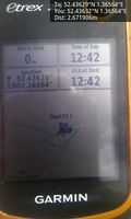
Arrived. @52.4363,1.3656

Church. @52.4363,1.3657
Church. @52.4363,1.3656
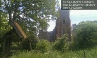
Church. @52.4363,1.3657

Church Sign. @52.4367,1.3621
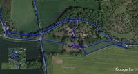
Google Earth Track


Achievements
Expeditions and Plans
| 2019-05-26 | ||
|---|---|---|
| Newark, New Jersey | Zubenelgenubi | The southern approach was via River Road, a name which (in the absence of c... |
| Norwich, United Kingdom | Sourcerer | A field perimeter near Denton, Norfolk, UK. |
| Braunschweig, Germany | Fippe | located on a field near Volkse. |
| Hannover, Germany | GeorgDerReisende | The hash lay on a fieldway east of Hagenburg-Altenhagen. |
Sourcerer's Expedition Links
2019-05-25_52_0 - 2019-05-26_52 1 - 2019-07-14_52_1 - KML file download of Sourcerer's expeditions for use with Google Earth.