Difference between revisions of "2019-07-23 47 7"
imported>Rincewind ([live picture]Hell, yeah. It was about time, too.) |
m (→Expedition) |
||
| (10 intermediate revisions by 4 users not shown) | |||
| Line 1: | Line 1: | ||
| − | |||
| − | |||
| − | |||
| − | |||
| − | |||
| − | |||
| − | |||
| − | |||
| − | |||
| − | |||
{{meetup graticule | {{meetup graticule | ||
| lat=47 | | lat=47 | ||
| Line 19: | Line 9: | ||
== Location == | == Location == | ||
| − | + | Rodersdorf near Basel, Switzerland | |
| + | |||
| + | == Plans == | ||
| + | A mere 13km as the bird flies, in a country as yet unhashed for me. | ||
| + | Weather was nice, map indicated it was reachable, long daylight hours... Go! | ||
== Participants == | == Participants == | ||
| − | + | [[User:Rincewind|Rincewind]] | |
| − | |||
| − | |||
| − | |||
| − | |||
== Expedition == | == Expedition == | ||
<!-- how it all turned out. your narrative goes here. --> | <!-- how it all turned out. your narrative goes here. --> | ||
| + | I looked the nearest street up in the Geohash Droid app and let my hashmobile guide and carry me there. I knew from the map it was close to a crossroads on the very end of Rodersdorf at the last building, already within agriculture of different sorts. | ||
| + | I parked the car at the crossroads and walked on towards the indicated direction. When the GPS display indicated 1m and I couldn't get it to flip back to zero again without falling into the hedges in my respectable-person-costume required for tomorrow's working day, I called it off as reasonably close and a success.<br> | ||
| + | basically, the hash was just two or three meters off the field road, at the edge of a tiny river in the brush. | ||
| + | On the way back, I saw a gentleman in the garden next to the hash coordinates being willingly busy half-hidden behind some stuff and greeted him. Suspecting he wasn't there by chance I asked him whether he was curious what I was doing just there, and indeed, he politely agreed that he was curious indeed... <br> | ||
| + | I explained to him the chance adventures based on Randall's comic and he understood it was a way to get around and see things in a game. Fair enough I think. His wife and dog joining in the explanation, I met a nice swiss couple on the expedition and made my way back to Basel again. | ||
| + | <br>"Of course", I forgot the mini USB cable required for the GPS screenshot download. <s>Will follow.</s>Finally updated! (2020-06-15) | ||
| − | == | + | == Photos == |
| − | |||
| − | |||
| − | |||
| − | |||
| − | |||
<gallery perrow="5"> | <gallery perrow="5"> | ||
| − | Image:2019-07-23_47_7_Rincewind_1563909284380.jpg| | + | Image:2019-07-23_47_7_Rincewind_1563909284380.jpg|Certainly not a halo. |
| − | |||
| − | + | Image:2019-07-23_47_7_Rincewind_1563913982995.jpg|Upon starting in Basel | |
| − | |||
| − | |||
| − | + | Image:2019-07-23_47_7_Rincewind_1563914090805.jpg|View towards the hash point (went further in just then) | |
| − | |||
| − | |||
| − | + | Image:2019-07-23_47_7_Rincewind_1563914146407.jpg|Beautiful surroundings looking from the coordinates | |
| − | + | Image:2019-07-23_47_7_Rincewind_1563914234168.jpg|Guardians-of-the-hash accomodation | |
| − | |||
| − | |||
| − | |||
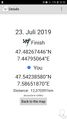
| − | + | Image:2019-07-23 47 7-gpsproof.jpg|Screenshots of the GPS unit. Did a lot of dancing for "1m". | |
| − | < | + | </gallery> |
| − | |||
| − | |||
| − | |||
| − | |||
| − | |||
| − | |||
| − | |||
| − | |||
| − | |||
| + | == Achievements == | ||
| + | {{#vardefine:ribbonwidth|800px}} | ||
| − | -- | + | {{Land geohash |
| − | + | | latitude = 47 | |
| − | + | | longitude = 7 | |
| − | + | | date = 2019-07-23 | |
| − | + | | name = Rincewind | |
| − | + | }} | |
| − | + | {{Easy_geohash | |
| − | + | | latitude = 47 | |
| + | | longitude = 7 | ||
| + | | date = 2019-07-23 | ||
| + | | name = Rincewind | ||
| + | }} | ||
| − | + | [[Category:Expeditions]] | |
| − | [[Category: | + | [[Category:Expeditions with photos]] |
| − | + | [[Category:Coordinates reached]] | |
| − | + | {{location|CH|SO}} | |
| − | [[Category: | ||
| − | |||
| − | |||
Latest revision as of 20:25, 15 June 2020
| Tue 23 Jul 2019 in 47,7: 47.4826745, 7.4479506 geohashing.info google osm bing/os kml crox |
Location
Rodersdorf near Basel, Switzerland
Plans
A mere 13km as the bird flies, in a country as yet unhashed for me. Weather was nice, map indicated it was reachable, long daylight hours... Go!
Participants
Expedition
I looked the nearest street up in the Geohash Droid app and let my hashmobile guide and carry me there. I knew from the map it was close to a crossroads on the very end of Rodersdorf at the last building, already within agriculture of different sorts.
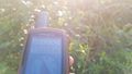
I parked the car at the crossroads and walked on towards the indicated direction. When the GPS display indicated 1m and I couldn't get it to flip back to zero again without falling into the hedges in my respectable-person-costume required for tomorrow's working day, I called it off as reasonably close and a success.
basically, the hash was just two or three meters off the field road, at the edge of a tiny river in the brush.
On the way back, I saw a gentleman in the garden next to the hash coordinates being willingly busy half-hidden behind some stuff and greeted him. Suspecting he wasn't there by chance I asked him whether he was curious what I was doing just there, and indeed, he politely agreed that he was curious indeed...
I explained to him the chance adventures based on Randall's comic and he understood it was a way to get around and see things in a game. Fair enough I think. His wife and dog joining in the explanation, I met a nice swiss couple on the expedition and made my way back to Basel again.
"Of course", I forgot the mini USB cable required for the GPS screenshot download. Will follow.Finally updated! (2020-06-15)
Photos

Certainly not a halo.
Upon starting in Basel
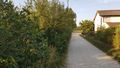
View towards the hash point (went further in just then)
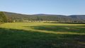
Beautiful surroundings looking from the coordinates
Guardians-of-the-hash accomodation
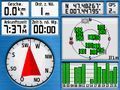
Screenshots of the GPS unit. Did a lot of dancing for "1m".


Achievements
Rincewind earned the Land geohash achievement
|
Rincewind has visited an Easy Geohash
|