Difference between revisions of "2020-04-01 49 8"
(→Plans) |
m (Location) |
||
| (6 intermediate revisions by one other user not shown) | |||
| Line 28: | Line 28: | ||
== Expedition == | == Expedition == | ||
<!-- how it all turned out. your narrative goes here. --> | <!-- how it all turned out. your narrative goes here. --> | ||
| + | It's hard to go hashing at the moment. You are still allowed to ride your bike - alone - but you must not take a train or a bus. So I can only go for hashes where I can reach home on the same day again. That limitsme to a radius from 20 KM at the weekend and - maybe - 10 KM during working days. | ||
| + | |||
| + | But today I was lucky. 8 KM from home. So I started at 12:15, rode to the hash, walked 60 m into the forest, found a path that wasn't on my map next to the hash, used it to walk back to my bike, rode back and reached home at 13:15 again. | ||
| + | |||
| + | Maybe I crossed my own way during hash-dancing and by walking back and riding in the same direction again, but gps sais, I didn't, and so I claim the tron-achievement for that. | ||
| + | |||
| + | All in all a very nice alternation from sitting at home and staring at my monitor. | ||
== Tracklog == | == Tracklog == | ||
<!-- if your GPS device keeps a log, you may post a link here --> | <!-- if your GPS device keeps a log, you may post a link here --> | ||
| + | [https://www.komoot.de/tour/165499326 20 KM by bike] | ||
== Photos == | == Photos == | ||
| Line 37: | Line 45: | ||
--> | --> | ||
<gallery perrow="5"> | <gallery perrow="5"> | ||
| + | Image:2020-04-01_49_8-1.jpg|60 m in there | ||
| + | Image:2020-04-01_49_8-2.jpg|left my bike here (proof of transport) | ||
| + | Image:2020-04-01_49_8-proof.png|proof | ||
| + | Image:2020-04-01_49_8-3.jpg|view to the north | ||
| + | Image:2020-04-01_49_8-4.jpg|and to the east (you can see the path next to the hash) | ||
| + | Image:2020-04-01_49_8-5.jpg|the west (fallen tree) | ||
| + | Image:2020-04-01_49_8-6.jpg|stupid grin | ||
</gallery> | </gallery> | ||
| Line 42: | Line 57: | ||
{{#vardefine:ribbonwidth|800px}} | {{#vardefine:ribbonwidth|800px}} | ||
<!-- Add any achievement ribbons you earned below, or remove this section --> | <!-- Add any achievement ribbons you earned below, or remove this section --> | ||
| + | {{land geohash | ||
| + | | latitude = 49 | ||
| + | | longitude = 8 | ||
| + | | date = 2020-04-01 | ||
| + | | name = DODO | ||
| + | }} | ||
| − | + | {{bicycle geohash | |
| − | + | | latitude = 49 | |
| − | + | | longitude = 8 | |
| − | + | | date = 2020-04-01 | |
| − | + | | name = DODO | |
| + | | distance = 20 KM | ||
| + | }} | ||
| − | + | {{Template:Tron | |
| − | + | | latitude = 49 | |
| − | + | | longitude = 8 | |
| − | + | | date = 2020-04-01 | |
| + | | name = DODO | ||
| + | | tracklog = https://www.komoot.de/tour/165499326 | ||
| + | | possessive = his | ||
| + | }} | ||
| − | |||
| − | |||
| − | |||
[[Category:Expeditions]] | [[Category:Expeditions]] | ||
| − | |||
| − | |||
| − | |||
| − | |||
| − | |||
| − | |||
| − | |||
[[Category:Coordinates reached]] | [[Category:Coordinates reached]] | ||
| − | + | {{location|DE|RP|GER}} | |
| − | |||
| − | |||
| − | |||
| − | |||
| − | |||
| − | |||
| − | |||
| − | |||
| − | |||
| − | |||
| − | |||
| − | |||
| − | |||
| − | |||
| − | |||
| − | |||
| − | |||
Latest revision as of 16:42, 1 April 2020
| Wed 1 Apr 2020 in 49,8: 49.2857639, 8.3224304 geohashing.info google osm bing/os kml crox |
Location
In a forest behind Harthausen (seen from Speyer).
Participants
Plans
Go there by bike during my lunch break.
Expedition
It's hard to go hashing at the moment. You are still allowed to ride your bike - alone - but you must not take a train or a bus. So I can only go for hashes where I can reach home on the same day again. That limitsme to a radius from 20 KM at the weekend and - maybe - 10 KM during working days.
But today I was lucky. 8 KM from home. So I started at 12:15, rode to the hash, walked 60 m into the forest, found a path that wasn't on my map next to the hash, used it to walk back to my bike, rode back and reached home at 13:15 again.
Maybe I crossed my own way during hash-dancing and by walking back and riding in the same direction again, but gps sais, I didn't, and so I claim the tron-achievement for that.
All in all a very nice alternation from sitting at home and staring at my monitor.
Tracklog
Photos
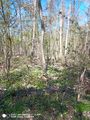
60 m in there
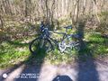
left my bike here (proof of transport)
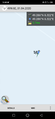
proof
view to the north
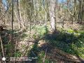
and to the east (you can see the path next to the hash)
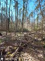
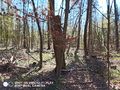
the west (fallen tree)
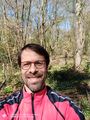
stupid grin


Achievements
DODO earned the Land geohash achievement
|
DODO earned the Bicycle geohash achievement
|
DODO earned the Tron achievement
|