Difference between revisions of "2020-05-23 34 -117"
From Geohashing
(Potential Plans) |
(add images (and participants)) |
||
| (5 intermediate revisions by 2 users not shown) | |||
| Line 1: | Line 1: | ||
| − | + | [[Image:2020-05-23 34 -117 masked grin.jpg|thumb|left]] | |
| − | [[Image: | ||
| − | |||
| − | |||
| − | |||
| − | |||
| − | |||
| − | |||
{{meetup graticule | {{meetup graticule | ||
| lat=34 | | lat=34 | ||
| Line 17: | Line 10: | ||
== Participants == | == Participants == | ||
| − | + | * [[User:Mckaysalisbury|McKay]] ([[User talk:Mckaysalisbury|talk]]) | |
| − | |||
== Plans == | == Plans == | ||
| − | It is [[Geohashing Day|Geohashing Day (observed)]], so I'm thinking of being there at about 2:00, but I' | + | * [[User:Mckaysalisbury|McKay]] ([[User talk:Mckaysalisbury|talk]]): It is [[Geohashing Day|Geohashing Day (observed)]], so I'm thinking of being there at about 2:00, but I'd be willing to go at a different time to meet up with anyone else (appropriately socially distant of course). |
== Expedition == | == Expedition == | ||
| − | + | We drove up there (we arrived a little late), explored the point, and played a little soccer in the small patch of grass next to the sports park that was closed. We grabbed a couple of frozen carbonated beverages from the nearby 7-11. | |
| − | |||
| − | |||
== Photos == | == Photos == | ||
| − | |||
| − | |||
| − | |||
<gallery perrow="5"> | <gallery perrow="5"> | ||
| + | Image:2020-05-23 34 -117 gps.png | gps | ||
| + | Image:2020-05-23 34 -117 masked grin.jpg | masked grin | ||
| + | Image:2020-05-23 34 -117 the spot.jpg | the spot | ||
</gallery> | </gallery> | ||
== Achievements == | == Achievements == | ||
{{#vardefine:ribbonwidth|800px}} | {{#vardefine:ribbonwidth|800px}} | ||
| − | + | {{Geohashing Day | latitude=34 | longitude=-117 | coorddate=2020-05-23 | mouseover=true | year=2020 | name=[[User:Mckaysalisbury|McKay]] ([[User talk:Mckaysalisbury|talk]])}} | |
| − | + | {{GeoSquishy FirstSip | latitude=34 | longitude=-117 | date=2020-05-23 | name=[[User:Mckaysalisbury|McKay]] ([[User talk:Mckaysalisbury|talk]])}} | |
| − | [[ | ||
| − | |||
| − | |||
| − | |||
[[Category:Expeditions]] | [[Category:Expeditions]] | ||
| − | |||
[[Category:Expeditions with photos]] | [[Category:Expeditions with photos]] | ||
| − | |||
| − | |||
| − | |||
| − | |||
| − | |||
[[Category:Coordinates reached]] | [[Category:Coordinates reached]] | ||
| − | + | {{location|US|CA|LO}} | |
| − | |||
| − | |||
| − | |||
| − | |||
| − | |||
| − | |||
| − | |||
| − | |||
| − | |||
| − | |||
| − | |||
| − | |||
| − | |||
| − | |||
| − | |||
| − | |||
| − | |||
Latest revision as of 20:05, 24 May 2020

| Sat 23 May 2020 in 34,-117: 34.1377331, -117.9557195 geohashing.info google osm bing/os kml crox |
Location
On a road's shoulder, by a canal, near Gordon Sports Park in Duarte, CA
Participants
Plans
- McKay (talk): It is Geohashing Day (observed), so I'm thinking of being there at about 2:00, but I'd be willing to go at a different time to meet up with anyone else (appropriately socially distant of course).
Expedition
We drove up there (we arrived a little late), explored the point, and played a little soccer in the small patch of grass next to the sports park that was closed. We grabbed a couple of frozen carbonated beverages from the nearby 7-11.
Photos
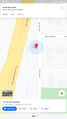
gps
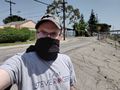
masked grin
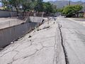
the spot


Achievements
McKay (talk) earned the 2020 Mouse Over Day achievement
|
McKay (talk) earned the First Sip GeoSquishy Achievement
|