Difference between revisions of "2008-06-25 41 -111"
From Geohashing
imported>Robyn (air hash, whee) |
imported>FippeBot m (Location) |
||
| (4 intermediate revisions by 3 users not shown) | |||
| Line 1: | Line 1: | ||
| − | The hashpoint was very close to being directly aligned with runway 35 at Logan-Cache airport where I was headed, and it was the runway in use. Zipped through it as an air hash just after sunset. | + | {{meetup graticule |
| + | | map=<map lat="41" lon="-111" date="2008-06-25" /> | ||
| + | | lat=41 | ||
| + | | lon=-111 | ||
| + | | date=2008-06-25 | ||
| + | | graticule_name=Ogden | ||
| + | | graticule_link=Ogden, Utah | ||
| + | }} | ||
| + | |||
| + | ==Expeditions== | ||
| + | |||
| + | The hashpoint was very close to being directly aligned with runway 35 at Logan-Cache airport where I was headed, and it was the runway in use. Zipped through it as an air hash just after sunset. --[[User:Robyn|Robyn]] | ||
| + | |||
| + | [[Image:2008-06-25 41 -111.gps.JPG|thumb|left]] | ||
| + | |||
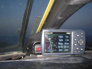
| + | I only have a usable picture eleven miles back, and it doesn't show date or coordinates, just that it is on approach to the airport where I was going. I'm counting it among my geohashes because I know I was there, but not towards any achievements because I have no proof. | ||
| + | [[Category:Expeditions]] | ||
| + | [[Category:Coordinates reached]] | ||
| + | <!-- Restricted area? --> | ||
| + | {{location|US|UT|CA}} | ||
Latest revision as of 05:27, 7 August 2019
| Wed 25 Jun 2008 in Ogden: 41.6739883, -111.8352589 geohashing.info google osm bing/os kml crox |
Expeditions
The hashpoint was very close to being directly aligned with runway 35 at Logan-Cache airport where I was headed, and it was the runway in use. Zipped through it as an air hash just after sunset. --Robyn
I only have a usable picture eleven miles back, and it doesn't show date or coordinates, just that it is on approach to the airport where I was going. I'm counting it among my geohashes because I know I was there, but not towards any achievements because I have no proof.
