Difference between revisions of "2020-09-04 -37 144"
Felix Dance (talk | contribs) (Added expedition template) |
(→Photos) |
||
| (8 intermediate revisions by 4 users not shown) | |||
| Line 1: | Line 1: | ||
| − | [[Image:{{{image| | + | [[Image:{{{image|Geohash 2020-09-04 -37 144 01 Steve.jpg}}}|thumb|left]] |
{{meetup graticule | {{meetup graticule | ||
| Line 16: | Line 16: | ||
== Expedition == | == Expedition == | ||
| + | ===Lachie=== | ||
| + | This geohash occurred during lockdown times, we were only allowed outside for 1 hour per day. Being a stickler and also a wilful misinterpretter, I took that to mean 1 hour was both a maximum and a minimum. I was doing my best to make the best of every minute of legal excercise. As such this had to be a super efficient geohash because I had important bike riding to do. | ||
| + | I rode as fast as I could from my house to the geohash. I had my phone mounted on my handlebars tracing my location so I wouldn't have to stop and take a GPS screen shot. I was also recording video because there was NO TIME FOR SELFIES. | ||
| + | |||
| + | I then rode to Afton Street which is the biggest hill within 5km of my home. I rode up and down it 7 times. Seven was a new record for me for the most laps of the hill in an hour so I was very happy. I made it home after only 57:53 of excercise. Fool that I am I through two minutes and seven seconds of excercise in the bin that day. Five days later I managed to do the hill ten times in one hour. Another five days later and the excercise restrictions doubled allowing even more times up and down that same hill. | ||
| + | |||
| + | ===Stevage=== | ||
| + | What a delightful discovery, a rare geohash within my 5 kilometre exercise boundary. Only just, though. Now I just had to make a loop that went through and still got the most out of my government-sanctioned hour of exercise per day. So convenient that the point was actually in the middle of the road. | ||
| + | |||
| + | I rode hard. I'd already memorised the point location, so I didn't have to stop and use the app to confirm where I was. I did an extra loop to be sure, dodging traffic and taking dodgy selfies. | ||
| + | |||
| + | [[File:Screen Shot 2020-09-11 at 11.47.23 am.png|400px]] | ||
== Photos == | == Photos == | ||
| − | + | [[File:Geohash 2020-09-04 -37 144 01 Steve.jpg|100px]] | |
| − | + | [[File:020-09-04_-37_144videoselfie.mp4|NO TIME FOR PHOTOS]] | |
| − | |||
== Achievements == | == Achievements == | ||
| Line 48: | Line 59: | ||
[[Category:Expeditions with photos]] | [[Category:Expeditions with photos]] | ||
[[Category:Coordinates reached]] | [[Category:Coordinates reached]] | ||
| − | {{location|AU|VIC| | + | {{location|AU|VIC|MV}} |
Latest revision as of 11:01, 28 February 2023
| Fri 4 Sep 2020 in -37,144: -37.7725921, 144.9277859 geohashing.info google osm bing/os kml crox |
Location
Doing ridebys on a main road in Brunswick
Participant
Expedition
Lachie
This geohash occurred during lockdown times, we were only allowed outside for 1 hour per day. Being a stickler and also a wilful misinterpretter, I took that to mean 1 hour was both a maximum and a minimum. I was doing my best to make the best of every minute of legal excercise. As such this had to be a super efficient geohash because I had important bike riding to do.
I rode as fast as I could from my house to the geohash. I had my phone mounted on my handlebars tracing my location so I wouldn't have to stop and take a GPS screen shot. I was also recording video because there was NO TIME FOR SELFIES.
I then rode to Afton Street which is the biggest hill within 5km of my home. I rode up and down it 7 times. Seven was a new record for me for the most laps of the hill in an hour so I was very happy. I made it home after only 57:53 of excercise. Fool that I am I through two minutes and seven seconds of excercise in the bin that day. Five days later I managed to do the hill ten times in one hour. Another five days later and the excercise restrictions doubled allowing even more times up and down that same hill.
Stevage
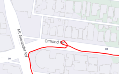
What a delightful discovery, a rare geohash within my 5 kilometre exercise boundary. Only just, though. Now I just had to make a loop that went through and still got the most out of my government-sanctioned hour of exercise per day. So convenient that the point was actually in the middle of the road.
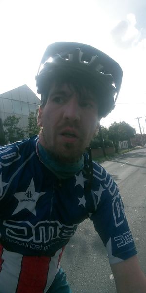
I rode hard. I'd already memorised the point location, so I didn't have to stop and use the app to confirm where I was. I did an extra loop to be sure, dodging traffic and taking dodgy selfies.
Photos
Achievements
Lachie and Stevage earned the Bicycle geohash achievement
|
Lachie and Stevage earned the Restricted area achievement
|


