Difference between revisions of "2020-12-10 47 7"
(An expedition message sent via Geohash Droid for Android.) |
m (Location) |
||
| (6 intermediate revisions by one other user not shown) | |||
| Line 1: | Line 1: | ||
| − | + | {{meetup graticule | |
| − | |||
| − | |||
| − | |||
| − | |||
| − | |||
| − | |||
| − | |||
| − | |||
| lat=47 | | lat=47 | ||
| lon=7 | | lon=7 | ||
| date=2020-12-10 | | date=2020-12-10 | ||
| − | }} | + | }} |
__NOTOC__ | __NOTOC__ | ||
== Location == | == Location == | ||
| − | + | Next to a house in Bittwil, Seeberg, Switzerland, Earth. | |
== Participants == | == Participants == | ||
| − | + | * [[User:Tungmar|Tungmar]]'s Buddy Orry | |
| − | |||
== Plans == | == Plans == | ||
| − | + | Tungmar spotted the has in the evening before in the graticule of his home town. Due to workload there was no way to take a day of and go geohashing. Instead he wrote to his buddy Orry who lives near by and told about the hash. Orry is the type of guy to walk and drive nights log just to create gigantic virtual triangles on a map - a perfect candidate for pointless activities like geohashing. There was no promise but good hope. | |
== Expedition == | == Expedition == | ||
| − | + | In the late afternoon, Tungmar received a picture and screenshots in Threema showing Orry actually went on the trip! Excitement! | |
| + | But apparently Google Maps lead Orry a few meters to close to the building and inside of the fenced garden - where he didn't went in. Interpreting the picture, Orry did not left the car - no wonder with all that snow - but he must have passed through the road next to the hash. So he was within the range of GPS accuracy next to the hash and as well in the range provided by the used, and not up to the task, tool Google Maps. But unless he turned the car in the field, which is unlikely, he did not pass the hash. | ||
| − | + | All blame goes to the used tool and to Tungmar to not provide enough precise satellite images or maps. | |
| − | |||
== Photos == | == Photos == | ||
| − | |||
| − | |||
| − | |||
<gallery perrow="5"> | <gallery perrow="5"> | ||
| + | Image:2020-12-10 47 7 Near.jpeg | At the spott | ||
| + | Image:2020-12-10 47 7 Arrived.jpeg | Looking closer | ||
| + | Image:2020-12-10 47 7 Photo.jpeg | Picture towards the most interesting sight | ||
| + | Image:2020-12-10 47 7 Hashalyse.jpeg | The cross marks the hash and the pin the approximate location of the picture. | ||
</gallery> | </gallery> | ||
| + | |||
== Achievements == | == Achievements == | ||
{{#vardefine:ribbonwidth|800px}} | {{#vardefine:ribbonwidth|800px}} | ||
| − | + | {{Blinded by Science|latitude=47|longitude=7|date=2020-12-10|reason=because a address is a imprecise location specifier|name=Orry}} | |
| − | + | {{Radio Yerevan|achievement=Puppet Master Geohash|detail=he was to lazy to provide more than coordinates|latitude=47|longitude=7| date=2020-12-10|user=[[User:Tungmar|Tungmar]]}} | |
| − | |||
| − | |||
| − | |||
| − | |||
| − | |||
| − | |||
| − | |||
| − | |||
| − | [[ | ||
| − | |||
| − | |||
| − | |||
| − | |||
[[Category:Expeditions]] | [[Category:Expeditions]] | ||
| − | |||
[[Category:Expeditions with photos]] | [[Category:Expeditions with photos]] | ||
| − | |||
| − | |||
| − | |||
| − | |||
| − | |||
| − | |||
| − | |||
| − | |||
| − | |||
[[Category:Coordinates not reached]] | [[Category:Coordinates not reached]] | ||
| − | |||
| − | |||
| − | |||
| − | |||
| − | |||
| − | |||
| − | |||
| − | |||
[[Category:Not reached - Technology]] | [[Category:Not reached - Technology]] | ||
| − | + | {{location|CH|BE}} | |
| − | |||
| − | |||
| − | |||
| − | |||
Latest revision as of 05:42, 15 December 2020
| Thu 10 Dec 2020 in 47,7: 47.1374132, 7.6602516 geohashing.info google osm bing/os kml crox |
Location
Next to a house in Bittwil, Seeberg, Switzerland, Earth.
Participants
- Tungmar's Buddy Orry
Plans
Tungmar spotted the has in the evening before in the graticule of his home town. Due to workload there was no way to take a day of and go geohashing. Instead he wrote to his buddy Orry who lives near by and told about the hash. Orry is the type of guy to walk and drive nights log just to create gigantic virtual triangles on a map - a perfect candidate for pointless activities like geohashing. There was no promise but good hope.
Expedition
In the late afternoon, Tungmar received a picture and screenshots in Threema showing Orry actually went on the trip! Excitement! But apparently Google Maps lead Orry a few meters to close to the building and inside of the fenced garden - where he didn't went in. Interpreting the picture, Orry did not left the car - no wonder with all that snow - but he must have passed through the road next to the hash. So he was within the range of GPS accuracy next to the hash and as well in the range provided by the used, and not up to the task, tool Google Maps. But unless he turned the car in the field, which is unlikely, he did not pass the hash.
All blame goes to the used tool and to Tungmar to not provide enough precise satellite images or maps.
Photos

At the spott

Looking closer
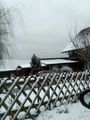
Picture towards the most interesting sight
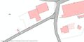
The cross marks the hash and the pin the approximate location of the picture.


Achievements
Orry earned the Blinded by Science Consolation Prize
|
Is it true that Tungmar earned the Puppet Master Geohash?
|