Difference between revisions of "2021-01-09 52 5"
m (subst-ing) |
|||
| (One intermediate revision by the same user not shown) | |||
| Line 3: | Line 3: | ||
{{meetup graticule | {{meetup graticule | ||
| − | | lat= | + | | lat=52 |
| − | | lon= | + | | lon=5 |
| − | | date= | + | | date=2021-01-09 |
}}<!-- edit as necessary --> | }}<!-- edit as necessary --> | ||
__NOTOC__ | __NOTOC__ | ||
| Line 39: | Line 39: | ||
[[Category:Expeditions with photos]] | [[Category:Expeditions with photos]] | ||
[[Category:Expedition without GPS]] | [[Category:Expedition without GPS]] | ||
| + | {{location|NL|UT}} | ||
Latest revision as of 20:25, 24 May 2024

| Sat 9 Jan 2021 in 52,5: 52.1082552, 5.2832894 geohashing.info google osm bing/os kml crox |
Location
The geohash is located in the National Park "De Utrechtse Heuvelrug", near Soesterberg. This area is known as "Kozakkenput". According to the map, the hash was close to an intersection of a footpath and a bridle path.
Participants
Plans
Cycle along the Verlengde Slotlaan, then continue on foot into the forest to get as close as possible.
Expedition
I left around 14:15 and cycled to the hash point. It was pretty cold (around 4°C), but sunny. There were a lot of other people walking and cycling in the area due to the current lockdown. Close to the hash point, I had to continue on foot as the muddy and icy footpaths were not doable by bike. I found the general area quite easily, but I could not get a very accurate GPS fix while there.
Photos
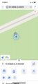
GPS proof
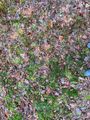
Somewhere here is the hash point
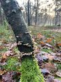
Tree next to the point
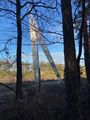
"Tweede Kristallisatie", sculpture between the path and the highway (A28)


