Difference between revisions of "2021-04-17 42 -83"
(create expedition page) |
(→Achievements: Last Woman Standing) |
||
| (13 intermediate revisions by 2 users not shown) | |||
| Line 1: | Line 1: | ||
| − | + | [[Image:2021-04-17 42 -83 track screenshot.jpg|thumb|left]] | |
| − | + | {{meetup graticule | |
| − | + | | lat=42 | |
| − | + | | lon=-83 | |
| − | + | | date=2021-04-17 | |
| − | + | }} | |
| − | |||
| − | |||
| − | | lat= | ||
| − | | lon= | ||
| − | | date= | ||
| − | }} | ||
__NOTOC__ | __NOTOC__ | ||
== Location == | == Location == | ||
| − | + | On westbound Vassar Drive halfway between Fielding Street and Patton Street, in Detroit's Evergreen Lahser 7/8 neighbourhood. | |
== Participants == | == Participants == | ||
| − | + | [[User:Alison|Alison]] ([[User talk:Alison|talk]]) | |
| − | |||
== Plans == | == Plans == | ||
| − | + | I literally just came up with the plans around 17:00 because I remembered that today's hash location is on a street in a street grid neighbourhood, so I could achieve Tron, Speed Racer, and No Batteries. I planned to take the following directions by car: | |
| + | |||
| + | * west out of my neighbourhood | ||
| + | * left Hilton | ||
| + | * right 8 Mile | ||
| + | * [https://en.wikipedia.org/wiki/Michigan_left around-then-right] Evergreen | ||
| + | * right Vassar | ||
| + | * hashpoint | ||
| + | * left Burt | ||
| + | * left 7 Mile | ||
| + | * left John R | ||
| + | * left Woodward Heights | ||
| + | * right Lenox back into my neighbourhood | ||
== Expedition == | == Expedition == | ||
| − | + | Pretty much as planned, except that I had to take a detour due to a train parked on the tracks at the level crossing on Hilton south of 9 Mile. I had to scroll around my phone's map (it was logging GPS) to determine the detour route, so I'm not going to claim No Batteries for today. The detour was as follows: | |
| + | |||
| + | * from SB Hilton/9 Mile | ||
| + | * left Troy | ||
| + | * right Bonner | ||
| + | * left Saratoga | ||
| + | * right Farrow | ||
| + | * left Academy | ||
| + | * right Wanda into Bennett | ||
| + | * right West End | ||
| + | * right 8 Mile into previously planned route | ||
| + | |||
| + | Also, a car turned left across my path at NB John R / State Fair, and one merged into my path at NB John R / Orchard. Thankfully I was able to avoid crashing into both cars. | ||
== Tracklog == | == Tracklog == | ||
| − | + | [[:File:2021-04-17 42 -83.gpx]] | |
== Photos == | == Photos == | ||
| − | |||
| − | |||
| − | |||
<gallery perrow="5"> | <gallery perrow="5"> | ||
| + | File:2021-04-17_42_-83_stopped_train.jpg| Stopped train at Hilton / Troy | ||
| + | File:2021-04-17_42_-83_renaissance_village_apts.jpg| Renaissance Village Apartments | ||
| + | File:2021-04-17_42_-83_hashpoint.jpg| Hashpoint | ||
| + | File:2021-04-17_42_-83_bad_left_turn_john_r_state_fair.jpg| Left turn in front of me at John R / State Fair | ||
| + | File:2021-04-17_42_-83_bad_merge_john_r_orchard.jpg| Merge in front of me at John R / Orchard | ||
| + | File:2021-04-17 42 -83 track screenshot.jpg| Track screenshot for Tron | ||
| + | File:2021-04-17 42 -83 Speed Racer screenshot.png| Speed Racer proof | ||
</gallery> | </gallery> | ||
== Achievements == | == Achievements == | ||
{{#vardefine:ribbonwidth|800px}} | {{#vardefine:ribbonwidth|800px}} | ||
| − | + | {{Tron | |
| − | + | | latitude = 42 | |
| − | + | | longitude = -83 | |
| − | + | | date = 2021-04-17 | |
| − | [[ | + | | tracklog = https://geohashing.site/geohashing/File:2021-04-17_42_-83.gpx |
| − | + | | possessive = her | |
| − | + | | name = [[User:Alison|Alison]] | |
| + | | image = 2021-04-17 42 -83 track screenshot.jpg | ||
| + | }} | ||
| + | {{Speed racer | ||
| + | | latitude = 42 | ||
| + | | longitude = -83 | ||
| + | | date = 2021-04-17 | ||
| + | | name = [[user:Alison|Alison]] | ||
| + | | image = 2021-04-17 42 -83 Speed Racer screenshot.png | ||
| + | | speed = 26 mph | ||
| + | }} | ||
| − | + | {{Last man standing | |
| − | + | | latitude = 42 | |
| − | [[ | + | | longitude = -83 |
| − | + | | date = 2021-04-17 | |
| + | | gender = woman | ||
| + | | name = [[User:Alison|Alison]] ([[User talk:Alison|talk]]) | ||
| + | }} | ||
| − | |||
| − | |||
| − | |||
[[Category:Expeditions]] | [[Category:Expeditions]] | ||
| − | |||
[[Category:Expeditions with photos]] | [[Category:Expeditions with photos]] | ||
| − | |||
| − | |||
| − | |||
| − | |||
| − | |||
[[Category:Coordinates reached]] | [[Category:Coordinates reached]] | ||
| − | + | {{location|US|MI|WY}} | |
| − | |||
| − | |||
| − | |||
| − | |||
| − | |||
| − | |||
| − | |||
| − | |||
| − | |||
| − | |||
| − | |||
| − | |||
| − | |||
| − | |||
| − | |||
| − | |||
| − | |||
Latest revision as of 02:29, 30 May 2021

| Sat 17 Apr 2021 in 42,-83: 42.4330494, -83.2449043 geohashing.info google osm bing/os kml crox |
Location
On westbound Vassar Drive halfway between Fielding Street and Patton Street, in Detroit's Evergreen Lahser 7/8 neighbourhood.
Participants
Plans
I literally just came up with the plans around 17:00 because I remembered that today's hash location is on a street in a street grid neighbourhood, so I could achieve Tron, Speed Racer, and No Batteries. I planned to take the following directions by car:
- west out of my neighbourhood
- left Hilton
- right 8 Mile
- around-then-right Evergreen
- right Vassar
- hashpoint
- left Burt
- left 7 Mile
- left John R
- left Woodward Heights
- right Lenox back into my neighbourhood
Expedition
Pretty much as planned, except that I had to take a detour due to a train parked on the tracks at the level crossing on Hilton south of 9 Mile. I had to scroll around my phone's map (it was logging GPS) to determine the detour route, so I'm not going to claim No Batteries for today. The detour was as follows:
- from SB Hilton/9 Mile
- left Troy
- right Bonner
- left Saratoga
- right Farrow
- left Academy
- right Wanda into Bennett
- right West End
- right 8 Mile into previously planned route
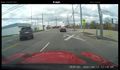
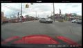
Also, a car turned left across my path at NB John R / State Fair, and one merged into my path at NB John R / Orchard. Thankfully I was able to avoid crashing into both cars.
Tracklog
Photos
Stopped train at Hilton / Troy
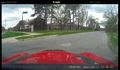
Renaissance Village Apartments
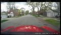
Hashpoint
Left turn in front of me at John R / State Fair
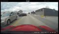
Merge in front of me at John R / Orchard
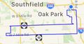
Track screenshot for Tron
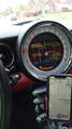
Speed Racer proof


Achievements
Alison earned the Tron achievement
|
Alison earned the Speed racer achievement
|
Alison (talk) earned the Last woman standing achievement
|