Difference between revisions of "2021-05-29 40 -5"
(→Expedition) |
|||
| (3 intermediate revisions by 3 users not shown) | |||
| Line 41: | Line 41: | ||
It was a relatively long two hours ride through quite a scenic landscape | It was a relatively long two hours ride through quite a scenic landscape | ||
| − | with little traffic. Closer to the destination, it got very mountainous with | + | with little traffic. The first part of the route I traveled again later in expedition [[2021-08-15 40 -4]]. Closer to the destination, it got very mountainous with |
winded roads and lots of other bikers with much more sporting ambition then | winded roads and lots of other bikers with much more sporting ambition then | ||
me. I guess some cursed the obstacle posed by my old Goldwing, calmly gliding | me. I guess some cursed the obstacle posed by my old Goldwing, calmly gliding | ||
| Line 51: | Line 51: | ||
When I finally reached the hiking base, I found it very crowded with many | When I finally reached the hiking base, I found it very crowded with many | ||
| − | cars and buses, but I got a parking space. So, then on to the geohash! | + | cars and buses, but I got a parking space. So, then on to the geohash |
| + | (I thought)! | ||
When I had checked the location on Google Maps, I could not really | When I had checked the location on Google Maps, I could not really | ||
| Line 70: | Line 71: | ||
== Photos == | == Photos == | ||
<gallery perrow="5"> | <gallery perrow="5"> | ||
| − | Image:2021-05-29_40_-5_L1040280.JPG | + | Image:2021-05-29_40_-5_L1040280.JPG| On the parking space of the Plataforma de Gredos, looking in the geohash direction. |
| − | | On the parking space of the Plataforma de Gredos, looking | + | Image:2021-05-29_40_-5_L1040281.JPG| It's behind that mountain, 2.8 km away. |
| − | |||
| − | Image:2021-05-29_40_-5_L1040281.JPG | ||
| − | | It's behind that mountain, 2.8 km away. | ||
</gallery> | </gallery> | ||
| Line 83: | Line 81: | ||
this section --> | this section --> | ||
| − | |||
| − | |||
| − | |||
| − | |||
| − | |||
| − | |||
| − | |||
| − | |||
| − | |||
| − | |||
| − | |||
| − | |||
| − | |||
| − | |||
[[Category:Expeditions]] | [[Category:Expeditions]] | ||
| − | |||
[[Category:Expeditions with photos]] | [[Category:Expeditions with photos]] | ||
| − | |||
| − | |||
| − | |||
| − | |||
| − | |||
| − | |||
| − | |||
| − | |||
| − | |||
[[Category:Coordinates not reached]] | [[Category:Coordinates not reached]] | ||
| − | |||
| − | |||
| − | |||
[[Category:Not reached - Mother Nature]] | [[Category:Not reached - Mother Nature]] | ||
| − | + | {{location|ES|CL|AV}} | |
| − | |||
| − | |||
| − | |||
| − | |||
| − | |||
| − | |||
| − | |||
| − | |||
| − | |||
| − | |||
| − | |||
Latest revision as of 16:04, 30 August 2021
| Sat 29 May 2021 in 40,-5: 40.2756551, -5.1987215 geohashing.info google osm bing/os kml crox |
Location
Close to a hiking base in the center of a regional park near Gredos.
Participants
Plans
Expedition
I live in graticule 40 -4, and the geohash there would have been much closer, but a quick check revealed that it was on private property, behind fence and gate. So I looked for alternative graticules, and this one looked very interesting. The geohash was in the center of the regional park Parque Regional de la Sierra de Gredos. There is just one single paved road into the park with a dead end at a hiking base with large parking space. The geohash was not far from this point, so I decided to go for it.
It was a relatively long two hours ride through quite a scenic landscape with little traffic. The first part of the route I traveled again later in expedition 2021-08-15 40 -4. Closer to the destination, it got very mountainous with winded roads and lots of other bikers with much more sporting ambition then me. I guess some cursed the obstacle posed by my old Goldwing, calmly gliding through the curves.
In the park, someone had written NO LOBOS (no wolfs) across the road at many places. Most of these writings had been modified to NO BOBOS (no fools).
When I finally reached the hiking base, I found it very crowded with many cars and buses, but I got a parking space. So, then on to the geohash (I thought)!
When I had checked the location on Google Maps, I could not really estimate the terrain from the satellite view. There was no street view available. Pitches turned out to be much more substantial than expected and there was a big mountain between me and the geohash. Lacking mountaineering equipment and experience, I refrained from trying to reach it.
On the ride back, some rain caught me which I had not expected, but it was over quickly and the returned Sun dried me long before I was back home.
Tracklog
Photos
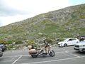
On the parking space of the Plataforma de Gredos, looking in the geohash direction.
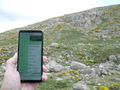
It's behind that mountain, 2.8 km away.

