Difference between revisions of "2021-07-24 52 5"
(Created page with "{{subst:Expedition}}") |
m (subst-ing) |
||
| (2 intermediate revisions by 2 users not shown) | |||
| Line 8: | Line 8: | ||
And DON'T FORGET to add your expedition and the best photo you took to the gallery on the Main Page! We'd love to read your report, but that means we first have to discover it! :) | And DON'T FORGET to add your expedition and the best photo you took to the gallery on the Main Page! We'd love to read your report, but that means we first have to discover it! :) | ||
-->{{meetup graticule | -->{{meetup graticule | ||
| − | | lat= | + | | lat=52 |
| − | | lon= | + | | lon=5 |
| − | | date= | + | | date=2021-07-24 |
}}<!-- edit as necessary --> | }}<!-- edit as necessary --> | ||
__NOTOC__ | __NOTOC__ | ||
== Location == | == Location == | ||
| − | + | On the Arnhemseweg in Driebergen. | |
== Participants == | == Participants == | ||
| − | + | [[User:Xnyhps|Xnyhps]] ([[User talk:Xnyhps|talk]]) | |
| − | |||
== Plans == | == Plans == | ||
| − | + | The Saturday the week before I happened to be cycling pas the Arnhemseweg as well. That was not a great experience. The cycle path is narrow, there were a lot of other cyclists and it was a busy road. I remembered thinking to myself "better not take this route again on a sunny Saturday". So of course, the next week on Saturday, the geohash lands exactly on this road... | |
| + | |||
| + | I decided to go for it anyway and picked out a route that would take me over this road as little as possible. | ||
== Expedition == | == Expedition == | ||
| − | + | The weather was great, but not as sunny as the week before, so also less busy. I cycled from Zeist over the Driebergseweg and then through Park Sparrendaal, which was a much better route. I went to the point, which was in the middle of the road. I crossed the road at the approximate place, but because it was quite busy didn't try to take a picture while there. | |
| − | |||
| − | |||
| − | |||
== Photos == | == Photos == | ||
| Line 34: | Line 32: | ||
--> | --> | ||
<gallery perrow="5"> | <gallery perrow="5"> | ||
| + | File:Park_Sparrendaal_Driebergen.jpeg | Park Sparrendaal where I took a short break | ||
| + | File:Hashpoint on Arnhemseweg.jpg | The hashpoint is somewhere on the road here | ||
| + | File:Proof 2021-07-24 52 5.png | Proof | ||
| + | File:Heidestein.jpg | Cycling back through Heidestein | ||
</gallery> | </gallery> | ||
| Line 40: | Line 42: | ||
<!-- Add any achievement ribbons you earned below, or remove this section --> | <!-- Add any achievement ribbons you earned below, or remove this section --> | ||
| − | |||
| − | |||
| − | |||
| − | |||
| − | |||
| − | |||
| − | |||
| − | |||
| − | |||
| − | |||
| − | |||
| − | |||
| − | |||
| − | |||
[[Category:Expeditions]] | [[Category:Expeditions]] | ||
| − | |||
[[Category:Expeditions with photos]] | [[Category:Expeditions with photos]] | ||
| − | |||
| − | |||
| − | |||
| − | |||
| − | |||
[[Category:Coordinates reached]] | [[Category:Coordinates reached]] | ||
| − | + | {{location|NL|UT}} | |
| − | |||
| − | |||
| − | |||
| − | |||
| − | |||
| − | |||
| − | |||
| − | |||
| − | |||
| − | |||
| − | |||
| − | |||
| − | |||
| − | |||
| − | |||
| − | |||
| − | |||
Latest revision as of 20:40, 24 May 2024
| Sat 24 Jul 2021 in 52,5: 52.0567163, 5.2970527 geohashing.info google osm bing/os kml crox |
Location
On the Arnhemseweg in Driebergen.
Participants
Plans
The Saturday the week before I happened to be cycling pas the Arnhemseweg as well. That was not a great experience. The cycle path is narrow, there were a lot of other cyclists and it was a busy road. I remembered thinking to myself "better not take this route again on a sunny Saturday". So of course, the next week on Saturday, the geohash lands exactly on this road...
I decided to go for it anyway and picked out a route that would take me over this road as little as possible.
Expedition
The weather was great, but not as sunny as the week before, so also less busy. I cycled from Zeist over the Driebergseweg and then through Park Sparrendaal, which was a much better route. I went to the point, which was in the middle of the road. I crossed the road at the approximate place, but because it was quite busy didn't try to take a picture while there.
Photos
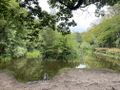
Park Sparrendaal where I took a short break
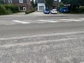
The hashpoint is somewhere on the road here
Proof
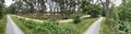
Cycling back through Heidestein


