Difference between revisions of "2021-08-03 65 28"
(Created page with "{{Subst:Expedition}}") |
m (subst-ing) |
||
| (5 intermediate revisions by 3 users not shown) | |||
| Line 1: | Line 1: | ||
| − | + | {{meetup graticule | |
| − | + | | lat=65 | |
| − | + | | lon=28 | |
| − | + | | date=2021-08-03 | |
| − | + | }} | |
| − | |||
| − | |||
| − | |||
| − | |||
| − | | lat= | ||
| − | | lon= | ||
| − | | date= | ||
| − | }} | ||
__NOTOC__ | __NOTOC__ | ||
== Location == | == Location == | ||
| − | + | On an open logging area near Käsmä, Kuusamo. | |
| + | |||
| + | The point on a topographic map: {{MapSiteLink | N = 7293030 | E = 589026 | title = Geohash+2021-08-03+65+28}} | ||
== Participants == | == Participants == | ||
| − | + | * [[User:Kripakko|Kripakko]] | |
| − | |||
| − | == | + | == Expedition == |
| − | + | I was visiting Kuusamo with my girlfriend, and this hashpoint happened to be reasonably close, quite easily accessible and, best of all, in a [[Virgin Graticule|virgin graticule]]. | |
| + | The weather was not optimal: it would rain for the whole day, and the temperature would be 10 °C at most. We had a rental car and I had an almost excessive rain outfit, so the conditions would not be a problem. | ||
| − | + | We drove along highway 20 and local road 18843 towards Käsmä and the hashpoint. The highway was in excellent condition despite the rain, whereas the local road was muddy and riddled with potholes. It was traversable with a slow enough speed but not very enjoyable. That went on for nine kilometres until the village of Käsmä where the road turned into a narrow forest road. Eventually we drove past the hashpoint, turned the car over and parked at a wide part of the road. I put on a rain coat, rain trousers and rubber boots and grabbed an umbrella, and then I left for the hashpoint on foot. My girlfriend stayed in the car. | |
| − | + | ||
| + | I got to walk through a coniferous swamp (Finnish: ''korpi'') into an open logging area that was only a couple of years old. To my surprise, there were copious amounts of berries growing at its border, and I spent a lot of time eating them. The hot and dry summer has been damaging to berry growth near my home in North Karelia, and most of the few berries that I have seen there have been small and not very juicy. This region seems to be better off since the berries were all delicious. | ||
| − | + | I went on and reached the hashpoint with ease. It was located near a groove in the terrain where some ground has been dug up to the sides, and it seems like new spruce saplings have been planted earlier this summer. I took a few pictures and then traced my steps back to the road and the car. Nothing interesting really happened at any point. | |
| − | |||
== Photos == | == Photos == | ||
| − | < | + | <gallery perrow="8"> |
| − | Image: | + | Image:2021-08-03_65_28_01-road.jpg | The unpaved local road in Käsmä. The sign says: rasputitsa, vehicles heavier than three tonnes not permitted. |
| − | -- | + | Image:2021-08-03_65_28_02-car.jpg | Where we parked the car, 200 metres to go as the crow flies. |
| − | + | Image:2021-08-03_65_28_03-bog.jpg | How the coniferous swamp looked like, very beautiful really. | |
| + | Image:2021-08-03_65_28_04-berries.jpg | Crowberries (''Empetrum nigrum''), bilberries (''Vaccinium myrtillus''), bog bilberries (''Vaccinium uliginosum'') and lingonberries (''Vaccinium vitis-idaea'') all growing together. | ||
| + | Image:2021-08-03_65_28_05-gpsr1.jpg | Proof of location. | ||
| + | Image:2021-08-03_65_28_06-gpsr2.jpg | Proof of date and time. | ||
| + | Image:2021-08-03_65_28_07-hashpoint.jpg | The hashpoint was at the middle of the picture, at the horizontal piece of rock in front of the tussock. | ||
| + | Image:2021-08-03_65_28_08-selfie.jpg | Selfie at the hashpoint. | ||
</gallery> | </gallery> | ||
== Achievements == | == Achievements == | ||
{{#vardefine:ribbonwidth|800px}} | {{#vardefine:ribbonwidth|800px}} | ||
| − | |||
| − | + | {{land geohash | latitude = 65 | longitude = 28 | date = 2021-08-03 | name = Kripakko }} | |
| − | + | {{Graticule unlocked | latitude = 65 | longitude = 28 | date = 2021-08-03 | name = Kripakko }} | |
| − | |||
| − | |||
| − | |||
| − | |||
| − | |||
| − | |||
| − | |||
| − | |||
| − | |||
| − | |||
[[Category:Expeditions]] | [[Category:Expeditions]] | ||
| − | |||
[[Category:Expeditions with photos]] | [[Category:Expeditions with photos]] | ||
| − | |||
| − | |||
| − | |||
| − | |||
| − | |||
[[Category:Coordinates reached]] | [[Category:Coordinates reached]] | ||
| − | + | {{location|FI|14}} | |
| − | |||
| − | |||
| − | |||
| − | |||
| − | |||
| − | |||
| − | |||
| − | |||
| − | |||
| − | |||
| − | |||
| − | |||
| − | |||
| − | |||
| − | |||
| − | |||
| − | |||
Latest revision as of 20:40, 24 May 2024
| Tue 3 Aug 2021 in 65,28: 65.7464904, 28.9424984 geohashing.info google osm bing/os kml crox |
Location
On an open logging area near Käsmä, Kuusamo.
The point on a topographic map: [1]
Participants
Expedition
I was visiting Kuusamo with my girlfriend, and this hashpoint happened to be reasonably close, quite easily accessible and, best of all, in a virgin graticule. The weather was not optimal: it would rain for the whole day, and the temperature would be 10 °C at most. We had a rental car and I had an almost excessive rain outfit, so the conditions would not be a problem.
We drove along highway 20 and local road 18843 towards Käsmä and the hashpoint. The highway was in excellent condition despite the rain, whereas the local road was muddy and riddled with potholes. It was traversable with a slow enough speed but not very enjoyable. That went on for nine kilometres until the village of Käsmä where the road turned into a narrow forest road. Eventually we drove past the hashpoint, turned the car over and parked at a wide part of the road. I put on a rain coat, rain trousers and rubber boots and grabbed an umbrella, and then I left for the hashpoint on foot. My girlfriend stayed in the car.
I got to walk through a coniferous swamp (Finnish: korpi) into an open logging area that was only a couple of years old. To my surprise, there were copious amounts of berries growing at its border, and I spent a lot of time eating them. The hot and dry summer has been damaging to berry growth near my home in North Karelia, and most of the few berries that I have seen there have been small and not very juicy. This region seems to be better off since the berries were all delicious.
I went on and reached the hashpoint with ease. It was located near a groove in the terrain where some ground has been dug up to the sides, and it seems like new spruce saplings have been planted earlier this summer. I took a few pictures and then traced my steps back to the road and the car. Nothing interesting really happened at any point.
Photos
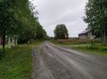
The unpaved local road in Käsmä. The sign says: rasputitsa, vehicles heavier than three tonnes not permitted.
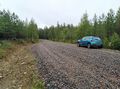
Where we parked the car, 200 metres to go as the crow flies.
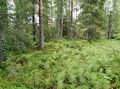
How the coniferous swamp looked like, very beautiful really.
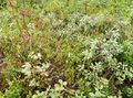
Crowberries (Empetrum nigrum), bilberries (Vaccinium myrtillus), bog bilberries (Vaccinium uliginosum) and lingonberries (Vaccinium vitis-idaea) all growing together.
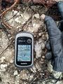
Proof of location.
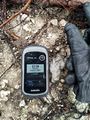
Proof of date and time.
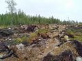
The hashpoint was at the middle of the picture, at the horizontal piece of rock in front of the tussock.
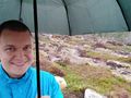
Selfie at the hashpoint.


Achievements
Kripakko earned the Land geohash achievement
|
Kripakko earned the Graticule Unlocked Achievement
|