Difference between revisions of "2021-08-06 52 9"
From Geohashing
(new report) |
m (Location) |
||
| (One intermediate revision by one other user not shown) | |||
| Line 1: | Line 1: | ||
| − | |||
| − | + | {{meetup graticule | |
| − | |||
| − | |||
| − | |||
| − | |||
| − | |||
| − | |||
| lat=52 | | lat=52 | ||
| lon=9 | | lon=9 | ||
| Line 14: | Line 7: | ||
__NOTOC__ | __NOTOC__ | ||
== Location == | == Location == | ||
| − | + | ||
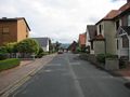
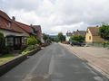
| + | The hash lay in the street An der Spille in Apelern. | ||
== Participants == | == Participants == | ||
| − | + | ||
| − | + | [[User:GeorgDerReisende|GeorgDerReisende]] | |
== Plans == | == Plans == | ||
| − | + | ||
| + | Traveling to Apelern and walking to the hash. | ||
== Expedition == | == Expedition == | ||
| − | + | ||
| + | Nothing spectacular. I traveled to Apelern by trains and a bus and then I walked straight to the hash. There was no need for a dance. It was there, on the street. I took the usual photos. | ||
| + | |||
| + | Afterhash I made a walk around the village. | ||
== Tracklog == | == Tracklog == | ||
| Line 30: | Line 28: | ||
== Photos == | == Photos == | ||
| − | < | + | |
| − | + | <gallery> | |
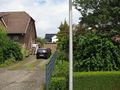
| − | -- | + | File:2021-08-06 52 9 GeorgDerReisende 3192.jpg | arrived |
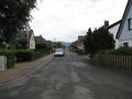
| − | + | File:2021-08-06 52 9 GeorgDerReisende 3248.jpg | the street An der Spille from the east | |
| + | File:2021-08-06 52 9 GeorgDerReisende 3249.jpg | proof 1 | ||
| + | File:2021-08-06 52 9 GeorgDerReisende 3250.jpg | proof 2 | ||
| + | File:2021-08-06 52 9 GeorgDerReisende 3251.jpg | looking north | ||
| + | File:2021-08-06 52 9 GeorgDerReisende 3252.jpg | east | ||
| + | File:2021-08-06 52 9 GeorgDerReisende 3253.jpg | south | ||
| + | File:2021-08-06 52 9 GeorgDerReisende 3254.jpg | west | ||
| + | File:2021-08-06 52 9 GeorgDerReisende 3255.jpg | me | ||
| + | File:2021-08-06 52 9 GeorgDerReisende 3257.jpg | the street An der Spille from the west | ||
</gallery> | </gallery> | ||
| − | + | [[Category:Expeditions]] | |
| − | |||
| − | |||
| − | + | [[Category:Expeditions with photos]] | |
| − | |||
| − | [[Category: | ||
| − | |||
| − | |||
| − | |||
| − | |||
| − | |||
| − | |||
| − | |||
| − | |||
| − | |||
| − | |||
| − | |||
| − | |||
| − | |||
| − | |||
| − | |||
| − | |||
| − | |||
| − | |||
[[Category:Coordinates reached]] | [[Category:Coordinates reached]] | ||
| − | + | {{location|DE|NI|SHG}} | |
| − | |||
| − | |||
| − | |||
| − | |||
| − | |||
| − | |||
| − | |||
| − | |||
| − | |||
| − | |||
| − | |||
| − | |||
| − | |||
| − | |||
| − | |||
| − | |||
| − | |||
Latest revision as of 08:42, 9 August 2021
| Fri 6 Aug 2021 in 52,9: 52.2944772, 9.3316250 geohashing.info google osm bing/os kml crox |
Location
The hash lay in the street An der Spille in Apelern.
Participants
Plans
Traveling to Apelern and walking to the hash.
Expedition
Nothing spectacular. I traveled to Apelern by trains and a bus and then I walked straight to the hash. There was no need for a dance. It was there, on the street. I took the usual photos.
Afterhash I made a walk around the village.
Tracklog
Photos
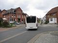
arrived
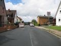
the street An der Spille from the east
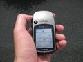
proof 1
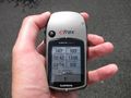
proof 2
looking north
east
south
west
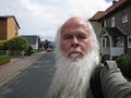
me
the street An der Spille from the west


