Difference between revisions of "2021-10-25 42 -83"
(→Achievements) |
m (subst-ing) |
||
| (2 intermediate revisions by 2 users not shown) | |||
| Line 8: | Line 8: | ||
And DON'T FORGET to add your expedition and the best photo you took to the gallery on the Main Page! We'd love to read your report, but that means we first have to discover it! :) | And DON'T FORGET to add your expedition and the best photo you took to the gallery on the Main Page! We'd love to read your report, but that means we first have to discover it! :) | ||
-->{{meetup graticule | -->{{meetup graticule | ||
| − | | lat= | + | | lat=42 |
| − | | lon= | + | | lon=-83 |
| − | | date= | + | | date=2021-10-25 |
}}<!-- edit as necessary --> | }}<!-- edit as necessary --> | ||
__NOTOC__ | __NOTOC__ | ||
| Line 54: | Line 54: | ||
}} | }} | ||
| − | |||
| − | |||
| − | |||
| − | |||
| − | |||
| − | |||
| − | |||
| − | |||
| − | |||
| − | |||
| − | |||
| − | |||
| − | |||
| − | |||
[[Category:Expeditions]] | [[Category:Expeditions]] | ||
| − | + | [[Category:Expeditions with photos]] | |
| − | [[Category:Expeditions with photos]] | ||
| − | |||
| − | |||
| − | |||
| − | |||
| − | |||
[[Category:Coordinates reached]] | [[Category:Coordinates reached]] | ||
| − | + | {{location|US|MI|WS}} | |
| − | |||
| − | |||
| − | |||
| − | |||
| − | |||
| − | |||
| − | |||
| − | |||
| − | |||
| − | |||
| − | |||
| − | |||
| − | |||
| − | |||
| − | |||
| − | |||
| − | |||
Latest revision as of 20:41, 24 May 2024
| Mon 25 Oct 2021 in 42,-83: 42.2872584, -83.7387920 geohashing.info google osm bing/os kml crox |
Location
Along the Border to Border Trail, a non-motorized trail in Ann Arbor, Michigan. Today's hashpoint is about 43 metres west of the westernmost point of Ann Arbor's Riverside Park.
Participants
Plans
I (Alison) am attempting to puppet master today's hash by directing my friend Jacob (who lives in Ann Arbor) to visit the hashpoint. I have to work and visit a tailor today, so I probably won't have time to visit it myself.
I messaged Jacob on Discord around 11:10 EDT this morning, and he agreed to visit the hashpoint later today and provide proof.
Expedition
Jacob visited the hashpoint around 21:00 tonight and provided me geotagged photos as proof. On his way back to the car, he saw a heron, which he also photographed.
I ended up visiting a hobby shop and buying scale modelling tools (a paint work stand, a hand-operated drill, and masking tape) instead of visiting a tailor, because I forgot to wear the right bra for the dress I need altered.
Tracklog
Photos

Jacob’s selfie at the hashpoint.
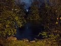
View of the Huron River from the hashpoint.
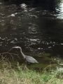
A heron that Jacob encountered while walking back to his car.


Achievements
Alison earned the Puppet Master Geohash achievement
|