Difference between revisions of "2008-07-09 41 -71"
From Geohashing
imported>Ben m (Captioning the pictures.) |
imported>FippeBot m (Location) |
||
| (3 intermediate revisions by 2 users not shown) | |||
| Line 1: | Line 1: | ||
| − | == | + | {{meetup graticule |
| + | | lat=41 | ||
| + | | lon=-71 | ||
| + | | date=2008-07-09 | ||
| + | | graticule_name=Providence | ||
| + | | graticule_link=Providence, Rhode Island | ||
| + | }} | ||
| − | + | ||
| + | ==Location== | ||
The site is located in Westport, MA, accessible via I-195 exit 11. It is immediately adjacent to White Oak Run Road, at house number ~60. | The site is located in Westport, MA, accessible via I-195 exit 11. It is immediately adjacent to White Oak Run Road, at house number ~60. | ||
| − | == | + | ==Participants== |
| + | * [[User:Ben|Ben]] | ||
| + | * Grace | ||
| + | |||
| + | ==Expedition== | ||
The hash was only a few meters off of the road, seemingly in the driveway of 60 White Oak Run Road. We decided to settle for the mailbox. The area seems to be a traditional New England phenomenon; a windy road with the occasional older house, and a smattering of new development as well (although where people commute to from Westport I'm not certain). | The hash was only a few meters off of the road, seemingly in the driveway of 60 White Oak Run Road. We decided to settle for the mailbox. The area seems to be a traditional New England phenomenon; a windy road with the occasional older house, and a smattering of new development as well (although where people commute to from Westport I'm not certain). | ||
| + | |||
| + | |||
| + | ==Photos== | ||
<gallery caption="Photos for the Day" widths="200px" heights="200px" perrow="3"> | <gallery caption="Photos for the Day" widths="200px" heights="200px" perrow="3"> | ||
| Line 13: | Line 27: | ||
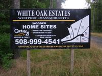
Image:2008-07-09-41-71-02.jpg|New development follows the old, it seems. None of the houses had been constructed yet... | Image:2008-07-09-41-71-02.jpg|New development follows the old, it seems. None of the houses had been constructed yet... | ||
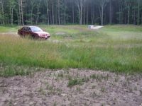
Image:2008-07-09-41-71-03.jpg|...but they had succeeded in clearing large swaths of forest nonetheless. This bit seems to be designated for drainage. | Image:2008-07-09-41-71-03.jpg|...but they had succeeded in clearing large swaths of forest nonetheless. This bit seems to be designated for drainage. | ||
| + | </gallery> | ||
| + | |||
| + | |||
| + | |||
| + | [[Category:Expeditions]] | ||
| + | [[Category:Expeditions with photos]] | ||
| + | [[Category:Coordinates reached]] | ||
| + | {{location|US|MA|BR}} | ||
Latest revision as of 05:47, 7 August 2019
| Wed 9 Jul 2008 in Providence: 41.5924897, -71.0418876 geohashing.info google osm bing/os kml crox |
Contents
Location
The site is located in Westport, MA, accessible via I-195 exit 11. It is immediately adjacent to White Oak Run Road, at house number ~60.
Participants
- Ben
- Grace
Expedition
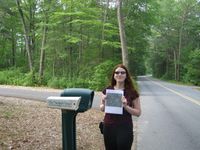
The hash was only a few meters off of the road, seemingly in the driveway of 60 White Oak Run Road. We decided to settle for the mailbox. The area seems to be a traditional New England phenomenon; a windy road with the occasional older house, and a smattering of new development as well (although where people commute to from Westport I'm not certain).
Photos
- Photos for the Day
Grace standing at 60 White Oak Run Road (Ben was taking the picture). The hash site was up the driveway a bit.


