Difference between revisions of "Pudasjärvi East, Finland"
m (Replacing Peeron with Geohashing.info) |
m (per Renaming Proposal) |
||
| (6 intermediate revisions by 2 users not shown) | |||
| Line 13: | Line 13: | ||
| s = [[Kajaani, Finland|Kajaani]] | | s = [[Kajaani, Finland|Kajaani]] | ||
| se = [[Sotkamo, Finland|Sotkamo]] | | se = [[Sotkamo, Finland|Sotkamo]] | ||
| − | }} | + | }} __NOTOC__ |
This graticule is located at [[65,27]]. {{Today's location|lat=65|lon=27}} | This graticule is located at [[65,27]]. {{Today's location|lat=65|lon=27}} | ||
| + | |||
| + | The centrum of the city of Pudasjärvi, named Kurenalus, is split in half by the E27° meridian. | ||
| + | While not much of a city by international standards, it is the home of around 4000 people. | ||
| + | The rest of the graticule is very sparsely inhabited countryside, though the Syöte area attracts many tourists | ||
| + | especially during the winter. | ||
| + | |||
| + | Some points of interest: | ||
| + | |||
| + | * Iso-Syöte, the southernmost fell in Finland: [https://syote.fi/en] | ||
| + | * Syöte National Park: [https://www.nationalparks.fi/syotenp] | ||
| + | * Olvassuo Nature Reserve: [https://en.wikipedia.org/wiki/Olvassuo_Strict_Nature_Reserve] (In Finnish: [https://www.luontoon.fi/olvassuo]) | ||
| + | |||
| + | == Regions in the graticule == | ||
| + | [[Image:regions_65_27_6.svg|x400px|frameless|Regions in the graticule]] | ||
| + | {| class="wikitable" | ||
| + | !Name!!Geohash<br />probability | ||
| + | |- | ||
| + | |<span style="color:rgb(255, 128, 128)">■</span> North Ostrobothnia||77.8% | ||
| + | |- | ||
| + | |<span style="color:rgb(0, 255, 0)">■</span> Lapland||14.4% | ||
| + | |- | ||
| + | |<span style="color:rgb(0, 0, 255)">■</span> Kainuu||7.8% | ||
| + | |} | ||
| + | |||
| + | == Municipalities in the graticule == | ||
| + | [[Image:regions_65_27_8.svg|x400px|frameless|Municipalities in the graticule]] | ||
| + | {| class="wikitable" | ||
| + | !Name!!Geohash<br />probability | ||
| + | |- | ||
| + | |<span style="color:rgb(0, 170, 85)">■</span> Pudasjärvi||66.2% | ||
| + | |- | ||
| + | |<span style="color:rgb(255, 128, 128)">■</span> Taivalkoski||8.7% | ||
| + | |- | ||
| + | |<span style="color:rgb(0, 255, 0)">■</span> Puolanka||7.8% | ||
| + | |- | ||
| + | |<span style="color:rgb(0, 0, 255)">■</span> Ranua||7.8% | ||
| + | |- | ||
| + | |<span style="color:rgb(255, 43, 213)">■</span> Posio||6.6% | ||
| + | |- | ||
| + | |<span style="color:rgb(0, 85, 170)">■</span> Utajärvi||2.9% | ||
| + | |- | ||
| + | |<span style="color:rgb(255, 213, 43)">■</span> Suomussalmi||0.00052% | ||
| + | |} | ||
| + | |||
| + | The tiny piece of Suomussalmi is only just barely visible in the map picture and has an area | ||
| + | of only 2.7 hectares (0.027 km<sup>2</sup> or 6.7 acres). | ||
| + | A geohash is expected to hit it once every 527 years or so, making a [[regional geohashing achievement]] extremely unlikely. | ||
| + | |||
| + | == Local Geohashers == | ||
| + | |||
| + | None | ||
| + | |||
| + | == Meetups == | ||
| + | |||
| + | * [[2023-05-27_65_27|2023-05-27]] ([[Mouse Over Day]] 2023), in Luokanvaara, Syöte national park. Reached successfully by [[User:Kripakko|Kripakko]] | ||
| + | |||
| + | == Notable Dates == | ||
| + | |||
| + | {{Graticule unlocked | latitude = 65 | longitude = 27 | date = 2023-05-27 | name = Kripakko }} | ||
[[Category:Inactive graticules]] | [[Category:Inactive graticules]] | ||
[[Category:Finland]] | [[Category:Finland]] | ||
[[Category:Split cities]] | [[Category:Split cities]] | ||
Latest revision as of 04:01, 20 March 2024
|
Latest Coordinates and Map Quick-Links | |
|---|---|
| Friday 2024-12-20 | 65.3803776, 27.0253565 |
| Saturday 2024-12-21 | 65.6789452, 27.1395403 |
| Sunday 2024-12-22 | 65.1625326, 27.2300457 |
| Monday 2024-12-23 | 65.4220962, 27.9876460 |
| Vanttauskoski | Kemijärvi | Salla |
| Pudasjärvi West | Pudasjärvi East | Taivalkoski |
| Vaala | Kajaani | Sotkamo |
|
Today's location: geohashing.info google osm bing/os kml crox | ||
This graticule is located at 65,27. Today's location
The centrum of the city of Pudasjärvi, named Kurenalus, is split in half by the E27° meridian. While not much of a city by international standards, it is the home of around 4000 people. The rest of the graticule is very sparsely inhabited countryside, though the Syöte area attracts many tourists especially during the winter.
Some points of interest:
- Iso-Syöte, the southernmost fell in Finland: [1]
- Syöte National Park: [2]
- Olvassuo Nature Reserve: [3] (In Finnish: [4])
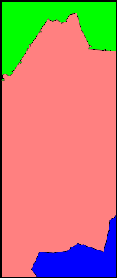
Regions in the graticule
| Name | Geohash probability |
|---|---|
| ■ North Ostrobothnia | 77.8% |
| ■ Lapland | 14.4% |
| ■ Kainuu | 7.8% |
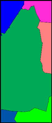
Municipalities in the graticule
| Name | Geohash probability |
|---|---|
| ■ Pudasjärvi | 66.2% |
| ■ Taivalkoski | 8.7% |
| ■ Puolanka | 7.8% |
| ■ Ranua | 7.8% |
| ■ Posio | 6.6% |
| ■ Utajärvi | 2.9% |
| ■ Suomussalmi | 0.00052% |
The tiny piece of Suomussalmi is only just barely visible in the map picture and has an area of only 2.7 hectares (0.027 km2 or 6.7 acres). A geohash is expected to hit it once every 527 years or so, making a regional geohashing achievement extremely unlikely.
Local Geohashers
None
Meetups
- 2023-05-27 (Mouse Over Day 2023), in Luokanvaara, Syöte national park. Reached successfully by Kripakko
Notable Dates
Kripakko earned the Graticule Unlocked Achievement
|

