Difference between revisions of "2018-02-19 -34 138"
From Geohashing
m (add categories + label more obviously as retrohash) |
m (subst-ing) |
||
| (4 intermediate revisions by 3 users not shown) | |||
| Line 7: | Line 7: | ||
--> | --> | ||
{{meetup graticule | {{meetup graticule | ||
| − | | lat= | + | | lat=-34 |
| − | | lon= | + | | lon=138 |
| − | | date= | + | | date=2018-02-19 |
| retro = 1 | | retro = 1 | ||
}}<!-- edit as necessary --> | }}<!-- edit as necessary --> | ||
| Line 37: | Line 37: | ||
Image:2018-02-19 -34 138 retro school.jpeg | School | Image:2018-02-19 -34 138 retro school.jpeg | School | ||
</gallery> | </gallery> | ||
| + | |||
| + | == Achievements == | ||
| + | {{Two to the N achievement | count = 0 | latitude = -34 | longitude = 138 | reached = true | retro = true | date = 2018-02-19 | name = [[User:XXOs|XXOs]] }} | ||
| + | {{Two to the N achievement | count = 0 | latitude = -34 | longitude = 138 | retro = true | date = 2018-02-19 | name = [[User:XXOs|XXOs]] }} | ||
[[Category:Retro coordinates reached]] | [[Category:Retro coordinates reached]] | ||
| − | |||
| − | |||
| − | |||
| − | |||
[[Category:Expeditions with photos]] | [[Category:Expeditions with photos]] | ||
| − | + | {{location|AU|SA|BU}} | |
| − | |||
| − | |||
| − | |||
| − | |||
| − | |||
| − | |||
| − | |||
| − | |||
| − | |||
| − | |||
| − | |||
| − | |||
| − | |||
| − | |||
| − | |||
| − | |||
| − | |||
| − | |||
| − | |||
| − | |||
| − | |||
| − | |||
| − | |||
| − | |||
| − | |||
| − | |||
| − | |||
| − | |||
| − | |||
| − | |||
| − | |||
| − | |||
| − | |||
| − | |||
| − | |||
| − | |||
| − | |||
Latest revision as of 20:11, 24 May 2024
| Mon 19 Feb 2018 in -34,138: -34.9482270, 138.6351766 geohashing.info google osm bing/os kml crox |
This is a retrohash that was done on 2022-02-04.
Location
On a school oval
Participants
Plans
I looked up nearby geohashes to my school and was surprised to find that there was one from my third week ever at the school! So, especially since it's now my last year at this school, I decided to do a retro hash of it.
Expedition
I waited until a point in time where there were no P.E. classes on the oval, and then I did it. As simple as it can be (without it being a Couch Potato Geohash).
Tracklog
Photos
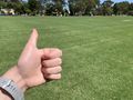
My hand
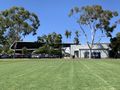
School


Achievements

XXOs earned the Two to the N achievement
by reaching 20 retro hashpoints including the one for 2018-02-19 -34 138 and is promoted to Level 0 (Retro coordinates reached).
XXOs earned the Two to the N achievement
by attempting to reach 20 retro hashpoints including the one for 2018-02-19 -34 138 and is promoted to Level 0 (Retro expeditions).