Difference between revisions of "2022-02-28 48 7"
From Geohashing
m (Update meetup time) |
(Coordinates reached) |
||
| Line 5: | Line 5: | ||
}} | }} | ||
== Location == | == Location == | ||
| − | In a field in [[wikipedia:Ohnenheim|Ohnenheim]]. | + | In the middle of a field in [[wikipedia:Ohnenheim|Ohnenheim]]. |
== Participants == | == Participants == | ||
| Line 14: | Line 14: | ||
== Expedition == | == Expedition == | ||
| + | The coordinates were located in an empty field near the D424 road. The road is bordered by a not-too-narrow cycle lane and runs in a relatively straight line from Sélestat to Marckolsheim. I'll have to check whether I qualified for a [[Juggernaut achievement]]. | ||
| + | |||
| + | After recording proof, I took a farm track to make a small detour in Ohnenheim then headed back home. | ||
== Photos == | == Photos == | ||
<gallery> | <gallery> | ||
| + | Image:2022-02-28 48 7 01.jpg | On my way to the geohash | ||
| + | Image:2022-02-28 48 7 02.jpg | My bicycle in front of the geohash | ||
| + | Image:2022-02-28 48 7 03.png | Coordinates reached | ||
| + | Image:2022-02-28 48 7 04.jpg | Stupid grin | ||
| + | Image:2022-02-28 48 7 05.jpg | Ohnenheim / Heidolsheim boundary marker | ||
| + | Image:2022-02-28 48 7 06.jpg | In Ohnenheim | ||
</gallery> | </gallery> | ||
== Achievements == | == Achievements == | ||
| + | {{#vardefine:ribbonwidth|100%}} | ||
| + | {{land geohash | ||
| + | | latitude = 48 | ||
| + | | longitude = 7 | ||
| + | | date = 2022-02-28 | ||
| + | | name = [[User:Baarde|Baarde]] | ||
| + | }} | ||
| + | {{bicycle geohash | ||
| + | | latitude = 48 | ||
| + | | longitude = 7 | ||
| + | | date = 2022-02-28 | ||
| + | | name = [[User:Baarde|Baarde]] | ||
| + | | distance = 26 km | ||
| + | | bothways = true | ||
| + | }} | ||
__NOTOC__ | __NOTOC__ | ||
| − | [[Category: | + | [[Category:Expeditions]] |
| + | [[Category:Expeditions with photos]] | ||
| + | [[Category:Coordinates reached]] | ||
{{location|FR|67}} | {{location|FR|67}} | ||
Latest revision as of 18:10, 28 February 2022
| Mon 28 Feb 2022 in 48,7: 48.1904393, 7.5324871 geohashing.info google osm bing/os kml crox |
Location
In the middle of a field in Ohnenheim.
Participants
Plans
I'm going to take an afternoon break to cycle to the geohash. I should reach the coordinates around 16:45.
Expedition
The coordinates were located in an empty field near the D424 road. The road is bordered by a not-too-narrow cycle lane and runs in a relatively straight line from Sélestat to Marckolsheim. I'll have to check whether I qualified for a Juggernaut achievement.
After recording proof, I took a farm track to make a small detour in Ohnenheim then headed back home.
Photos
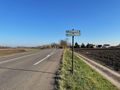
On my way to the geohash
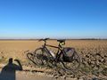
My bicycle in front of the geohash
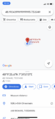
Coordinates reached
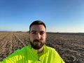
Stupid grin
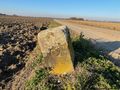
Ohnenheim / Heidolsheim boundary marker
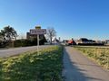
In Ohnenheim


Achievements
Baarde earned the Land geohash achievement
|
Baarde earned the Bicycle geohash achievement
|