Difference between revisions of "2022-04-13 58 6"
From Geohashing
(→Photos) |
(→Location) |
||
| (12 intermediate revisions by 3 users not shown) | |||
| Line 15: | Line 15: | ||
== Location == | == Location == | ||
<!-- where you've surveyed the hash to be --> | <!-- where you've surveyed the hash to be --> | ||
| + | Close to Fv44 near Mong between Egersund and Sokndal, Norway. | ||
== Participants == | == Participants == | ||
<!-- who attended: If you link to your wiki user name in this section, your expedition will be picked up by the various statistics generated for geohashing. You may use three tildes ~ as a shortcut to automatically insert the user signature of the account you are editing with. | <!-- who attended: If you link to your wiki user name in this section, your expedition will be picked up by the various statistics generated for geohashing. You may use three tildes ~ as a shortcut to automatically insert the user signature of the account you are editing with. | ||
--> | --> | ||
| − | + | *[[User:Pica42|Pica42]] | |
| − | |||
| − | |||
== Expedition == | == Expedition == | ||
<!-- how it all turned out. your narrative goes here. --> | <!-- how it all turned out. your narrative goes here. --> | ||
| − | + | On today's trip to a nearby hash, 74 km one way, it was also the intention to find a geocache. The hash was not a problem but I could not find the cache. | |
| − | |||
| − | |||
== Photos == | == Photos == | ||
| Line 35: | Line 32: | ||
<gallery perrow="5"> | <gallery perrow="5"> | ||
| − | Image:2022-04-13_58_6_Pica42_1649853564378.jpg| | + | Image:2022-04-13_58_6_Pica42_1649853564378.jpg|Sokndalsveien [https://openstreetmap.org/?mlat=58.37776940&mlon=6.13057640&zoom=16 @58.3778,6.1306] |
Image:Screenshot_20220413-01_Geohash_Droid.jpg | Image:Screenshot_20220413-01_Geohash_Droid.jpg | ||
| − | Image:20220413_01.jpg | + | Image:20220413_01.jpg|View to the north. |
| − | Image:20220413_02.jpg | + | Image:20220413_02.jpg|View to the west. |
| − | Image:20220413_03.jpg | + | Image:20220413_03.jpg|View to the south. |
| − | + | Image:20220413_04.jpg|View to the east. | |
</gallery> | </gallery> | ||
| Line 47: | Line 44: | ||
<!-- Add any achievement ribbons you earned below, or remove this section --> | <!-- Add any achievement ribbons you earned below, or remove this section --> | ||
| − | |||
| − | |||
| − | |||
| − | |||
| − | |||
| − | |||
| − | |||
| − | |||
| − | |||
| − | |||
| − | |||
| − | |||
| − | |||
| − | |||
[[Category:Expeditions]] | [[Category:Expeditions]] | ||
| − | |||
[[Category:Expeditions with photos]] | [[Category:Expeditions with photos]] | ||
| − | |||
| − | |||
| − | |||
| − | |||
| − | |||
[[Category:Coordinates reached]] | [[Category:Coordinates reached]] | ||
| + | {{location|NO|11}} | ||
| − | + | {{land geohash |name=[[User:Pica42|Pica42]] |date=2022-04-13 |latitude=58 |longitude=6 }} | |
| − | |||
| − | |||
| − | |||
| − | |||
| − | |||
| − | |||
| − | |||
| − | |||
| − | |||
| − | |||
| − | |||
| − | |||
| − | |||
| − | [[ | ||
| − | |||
| − | |||
Latest revision as of 18:03, 20 November 2022
| Wed 13 Apr 2022 in 58,6: 58.3777196, 6.1305924 geohashing.info google osm bing/os kml crox |
Location
Close to Fv44 near Mong between Egersund and Sokndal, Norway.
Participants
Expedition
On today's trip to a nearby hash, 74 km one way, it was also the intention to find a geocache. The hash was not a problem but I could not find the cache.
Photos
Sokndalsveien @58.3778,6.1306

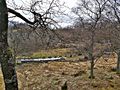
View to the north.
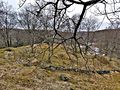
View to the west.
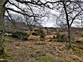
View to the south.
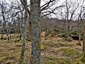
View to the east.


Achievements
Pica42 earned the Land geohash achievement
|