Difference between revisions of "2022-04-15 -36 146"
(Created page with "{{subst:Expedition}}") |
m (subst-ing) |
||
| (12 intermediate revisions by 3 users not shown) | |||
| Line 1: | Line 1: | ||
| − | + | [[File:1f114ed0-d58e-4737-aa76-027906523fc4.jpg|400px|thumb|left]] | |
| − | + | {{meetup graticule | |
| − | + | | lat=-36 | |
| − | + | | lon=146 | |
| − | + | | date=2022-04-15 | |
| − | + | }} | |
| + | __NOTOC__ | ||
| − | + | <br style="clear:left"> | |
| − | |||
| − | |||
| − | |||
| − | |||
| − | |||
| − | |||
== Location == | == Location == | ||
| − | + | In a paddock 900m off the Wangaratta-Whitfield Road. | |
== Participants == | == Participants == | ||
| − | + | [[User:Felix Dance|Felix Dance]] | |
| − | |||
== Plans == | == Plans == | ||
| − | + | Felix's plan was to ignore this geohash, as he attempted a 130km bike ride from Wangaratta to a lodge on top of Mt Hotham. | |
== Expedition == | == Expedition == | ||
| − | + | Something went wrong. It's unclear how the plan failed exactly, but somehow Felix ended up right at the hash at 11:12am local time. | |
| + | |||
| + | === Update: Felix Dance === | ||
| + | Yes indeed, something had gone wrong. I had seen the hash while riding the train to Wangaratta and almost immediately decided against it. I had over 150 kms to ride on my bulky Surly Troll, which included getting to the top of Mt Hotham, 1861m, and I wanted to do it before my lodge companions had gone to bed. | ||
| + | |||
| + | Then [[User:Talex|Talex]] messaged me to point it out. I refused to do it. I got off the train. I started riding towards the Great Alpine Rd and not towards the hash. But then... I changed direction and went and did it anyway. Aggghh. | ||
| + | |||
| + | The road in was fairly simple, although with little shoulder and a lot of battling the caravan traffic. A little under an hour later I turned right onto a dirt track (and directly away from my ultimate destination of Mt Hotham). As I rode along this track a farm ute started following me from behind a fence, warily watching where I was going. I started to get a bit worried about my chances of success. | ||
| + | |||
| + | But the road to the hash was long. I went past that farm, and then another, and then another. After 2.3 kms I was near the hash so I dumped the bike and continued on foot, the barbed wire fence being easily crossed. | ||
| + | |||
| + | But jeez it was a long way into the paddock. 850m each way. I had to get through several more barbed wire fences on my way there. And the ground was very lumpy and deep with grass. There were black spiders scurrying into the contraction cracks in the mud. A fox got startled and sprinted away from just in front of me. A few kangaroos watched from a distance. | ||
| + | |||
| + | Just as I was about to get through yet another fence, this one looking like it would actually present some difficulty, I was there. I took some photos while a curious cow came up to me and then ambled off, suddenly startled. I messaged my compatriots in the gchat to announce my change of heart about the geohash. | ||
| + | |||
| + | The return was much easier, the unknowns largely removed. I got on my bike and continued towards Mt Hotham, discovering a beautiful little unsealed road across the valley that I would never have had occasion to use had I gone directly from Wangaratta along the Alpine Highway. I arrived at the top of Hotham just after 10pm. | ||
== Tracklog == | == Tracklog == | ||
| − | + | {{ Tracklog | Tracklog 2022-04-15 -36 146 Wang to Hoth.gpx }} | |
== Photos == | == Photos == | ||
| − | + | ||
| − | |||
| − | |||
<gallery perrow="5"> | <gallery perrow="5"> | ||
| + | |||
| + | Image:2022-04-15_-36_146_Felix Dance_1649990283066.jpg|Geohash success! | ||
| + | |||
| + | Image:2022-04-15_-36_146_Felix Dance_1649990319521.jpg|Back at the bike | ||
| + | |||
| + | Image:2022-04-15_-36_146_Felix Dance_1649990330585.jpg|Road to the hash | ||
| + | |||
| + | Image:2022-04-15_-36_146_Felix Dance_1649990350661.jpg|Hash scenery and cow | ||
</gallery> | </gallery> | ||
== Achievements == | == Achievements == | ||
{{#vardefine:ribbonwidth|800px}} | {{#vardefine:ribbonwidth|800px}} | ||
| − | |||
| − | |||
| − | |||
| − | |||
| − | |||
| − | + | {{bicycle geohash | |
| − | + | | latitude = -36 | |
| − | + | | longitude = 146 | |
| − | [[ | + | | date = 2022-04-15 |
| − | -- | + | | name = [[User:Felix Dance|Felix Dance]] |
| + | | distance = 153 kms | ||
| + | | bothways = true (optional) | ||
| + | | image = 2022-04-15_-36_146_Felix Dance_1649990319521.jpg | ||
| − | + | }} | |
| − | |||
[[Category:Expeditions]] | [[Category:Expeditions]] | ||
| − | |||
[[Category:Expeditions with photos]] | [[Category:Expeditions with photos]] | ||
| − | |||
| − | |||
| − | |||
| − | |||
| − | |||
[[Category:Coordinates reached]] | [[Category:Coordinates reached]] | ||
| − | + | {{location|AU|VIC|WG}} | |
| − | |||
| − | |||
| − | |||
| − | |||
| − | |||
| − | |||
| − | |||
| − | |||
| − | |||
| − | |||
| − | |||
| − | |||
| − | |||
| − | |||
| − | |||
| − | |||
| − | |||
Latest revision as of 20:46, 24 May 2024

| Fri 15 Apr 2022 in -36,146: -36.5309590, 146.3588973 geohashing.info google osm bing/os kml crox |
Location
In a paddock 900m off the Wangaratta-Whitfield Road.
Participants
Plans
Felix's plan was to ignore this geohash, as he attempted a 130km bike ride from Wangaratta to a lodge on top of Mt Hotham.
Expedition
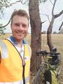
Something went wrong. It's unclear how the plan failed exactly, but somehow Felix ended up right at the hash at 11:12am local time.
Update: Felix Dance
Yes indeed, something had gone wrong. I had seen the hash while riding the train to Wangaratta and almost immediately decided against it. I had over 150 kms to ride on my bulky Surly Troll, which included getting to the top of Mt Hotham, 1861m, and I wanted to do it before my lodge companions had gone to bed.
Then Talex messaged me to point it out. I refused to do it. I got off the train. I started riding towards the Great Alpine Rd and not towards the hash. But then... I changed direction and went and did it anyway. Aggghh.
The road in was fairly simple, although with little shoulder and a lot of battling the caravan traffic. A little under an hour later I turned right onto a dirt track (and directly away from my ultimate destination of Mt Hotham). As I rode along this track a farm ute started following me from behind a fence, warily watching where I was going. I started to get a bit worried about my chances of success.
But the road to the hash was long. I went past that farm, and then another, and then another. After 2.3 kms I was near the hash so I dumped the bike and continued on foot, the barbed wire fence being easily crossed.
But jeez it was a long way into the paddock. 850m each way. I had to get through several more barbed wire fences on my way there. And the ground was very lumpy and deep with grass. There were black spiders scurrying into the contraction cracks in the mud. A fox got startled and sprinted away from just in front of me. A few kangaroos watched from a distance.
Just as I was about to get through yet another fence, this one looking like it would actually present some difficulty, I was there. I took some photos while a curious cow came up to me and then ambled off, suddenly startled. I messaged my compatriots in the gchat to announce my change of heart about the geohash.
The return was much easier, the unknowns largely removed. I got on my bike and continued towards Mt Hotham, discovering a beautiful little unsealed road across the valley that I would never have had occasion to use had I gone directly from Wangaratta along the Alpine Highway. I arrived at the top of Hotham just after 10pm.
Tracklog
Photos

Geohash success!
Back at the bike
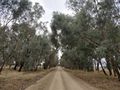
Road to the hash
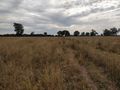
Hash scenery and cow


Achievements
Felix Dance earned the Bicycle geohash achievement
|