Difference between revisions of "2022-04-19 52 9"
m (Adding hours) |
|||
| (3 intermediate revisions by 2 users not shown) | |||
| Line 1: | Line 1: | ||
| − | {{meetup graticule |lat=52|lon=9 | + | {{meetup graticule|date=2022-04-19|lat=52|lon=9}} |
| − | == Location == | + | ==Location== |
| − | This Geohash is located | + | This Geohash is located next to a path in [[wikipedia:Harsum|Klein Förste]]. |
| − | == Participants == | + | ==Participants== |
*[[User:JoDaEmPa|JoDaEmPa]] | *[[User:JoDaEmPa|JoDaEmPa]] | ||
*[[User:Fippe|Fippe]] | *[[User:Fippe|Fippe]] | ||
| − | == Plans == | + | ==Plans== |
Wie schauts mit 10 Uhr ? -- [[User:JoDaEmPa|JoDaEmPa]] ([[User talk:JoDaEmPa|talk]]) [https://openstreetmap.org/?mlat=52.15808170&mlon=9.96903730&zoom=16 @52.1581,9.9690] 20:32, 18 April 2022 (GMT+02:00) | Wie schauts mit 10 Uhr ? -- [[User:JoDaEmPa|JoDaEmPa]] ([[User talk:JoDaEmPa|talk]]) [https://openstreetmap.org/?mlat=52.15808170&mlon=9.96903730&zoom=16 @52.1581,9.9690] 20:32, 18 April 2022 (GMT+02:00) | ||
| − | : | + | :Okay! --[[User:Fippe|Fippe]] ([[User talk:Fippe|talk]]) 18:37, 18 April 2022 (UTC) |
| − | == Expedition == | + | ==Expedition== |
| − | + | ===Fippe=== | |
| + | I cycled there in the morning and arrived a few minutes before 10:00. The coordinates were not on the path like I had assumed, but between the path and some unused train tracks that run parallel to the path but more elevated. After locating the coordinates I went back down to my bike and saw JoDaEmPa arriving. We talked and went back up, where JoDaEmPa also located the coordinates. He had prepared an OpenCache for the location, which we both signed. We checked out the nearby rail brige over the highway, and then went back to our bikes and back home afterwards. | ||
| − | == Photos == | + | ==Photos== |
| − | < | + | ===Fippe=== |
| − | + | [[File:2022-04-19 52 9 03 Surroundings.jpg|Surroundings|1000px]] | |
| − | -- | + | <gallery> |
| − | + | 2022-04-19 52 9 01 Proof.jpg | Proof | |
| + | 2022-04-19 52 9 02 Geohash.jpg | The Geohash | ||
| + | 2022-04-19 52 9 04 Site.jpg | The site of the Geohash | ||
| + | 2022-04-19 52 9 05 Path.jpg | The path near the Geohash | ||
| + | 2022-04-19 52 9 06 Site.jpg | The Geohash viewed from the path | ||
| + | 2022-04-19 52 9 07 Train tracks.jpg | On the train tracks | ||
| + | 2022-04-19 52 9 08 JoDaEmPa.jpg | JoDaEmPa | ||
</gallery> | </gallery> | ||
| − | == | + | ==Ribbons== |
| − | {{#vardefine:ribbonwidth| | + | {{#vardefine:ribbonwidth|100%}} |
| − | <!-- | + | {{land geohash|date=2022-04-19|latitude=52|longitude=9|name=[[User:JoDaEmPa|JoDaEmPa]] and [[User:Fippe|Fippe]]|image=2022-04-19 52 9 02 Geohash.jpg}} |
| + | {{bicycle geohash|date=2022-04-19|latitude=52|longitude=9|name=[[User:JoDaEmPa|JoDaEmPa]]|distance=<!--? km-->|bothways=true}} | ||
| + | {{bicycle geohash|date=2022-04-19|latitude=52|longitude=9|name=[[User:Fippe|Fippe]]|image=2022-04-19 52 9 06 Site.jpg|distance=42 km|bothways=true}} | ||
| + | {{earliest geohasher|date=2022-04-19|latitude=52|longitude=9|name=[[User:Fippe|Fippe]]}} | ||
| − | + | __NOTOC__ | |
| − | |||
| − | |||
[[Category:Expeditions]] | [[Category:Expeditions]] | ||
| − | + | [[Category:Coordinates reached]] | |
[[Category:Expeditions with photos]] | [[Category:Expeditions with photos]] | ||
| − | + | {{location|DE|NI|HI}} | |
| − | + | {{user categories|user=Fippe|bike=42|hours=09 10}} | |
| − | |||
| − | |||
| − | |||
| − | |||
| − | |||
| − | |||
| − | |||
| − | |||
| − | |||
| − | |||
| − | |||
| − | |||
| − | |||
| − | |||
| − | |||
| − | |||
| − | |||
| − | |||
| − | |||
| − | |||
| − | |||
| − | |||
| − | |||
Latest revision as of 19:54, 11 December 2022
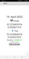
| Tue 19 Apr 2022 in 52,9: 52.2228856, 9.9320872 geohashing.info google osm bing/os kml crox |
Location
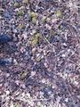
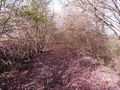
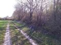
This Geohash is located next to a path in Klein Förste.
Participants
Plans
Wie schauts mit 10 Uhr ? -- JoDaEmPa (talk) @52.1581,9.9690 20:32, 18 April 2022 (GMT+02:00)
Expedition
Fippe
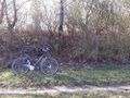
I cycled there in the morning and arrived a few minutes before 10:00. The coordinates were not on the path like I had assumed, but between the path and some unused train tracks that run parallel to the path but more elevated. After locating the coordinates I went back down to my bike and saw JoDaEmPa arriving. We talked and went back up, where JoDaEmPa also located the coordinates. He had prepared an OpenCache for the location, which we both signed. We checked out the nearby rail brige over the highway, and then went back to our bikes and back home afterwards.
Photos
Fippe

Proof
The Geohash
The site of the Geohash
The path near the Geohash
The Geohash viewed from the path
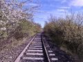
On the train tracks
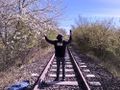
JoDaEmPa


Ribbons
JoDaEmPa and Fippe earned the Land geohash achievement
|
JoDaEmPa earned the Bicycle geohash achievement
|
Fippe earned the Bicycle geohash achievement
|
Fippe earned the Earliest geohasher achievement
|