Difference between revisions of "2022-04-24 50 11"
From Geohashing
ScepticAnna (talk | contribs) (Created page with "{{subst:Expedition |lat = 50 |lon = 11 |date = 2022-04-24 }}") |
m (Location) |
||
| (10 intermediate revisions by 2 users not shown) | |||
| Line 14: | Line 14: | ||
__NOTOC__ | __NOTOC__ | ||
== Location == | == Location == | ||
| − | + | In a park in Jena, on top of the Autobahn. | |
== Participants == | == Participants == | ||
<!-- who attended: If you link to your wiki user name in this section, your expedition will be picked up by the various statistics generated for geohashing. You may use three tildes ~ as a shortcut to automatically insert the user signature of the account you are editing with. | <!-- who attended: If you link to your wiki user name in this section, your expedition will be picked up by the various statistics generated for geohashing. You may use three tildes ~ as a shortcut to automatically insert the user signature of the account you are editing with. | ||
--> | --> | ||
| + | [[User:ScepticAnna|Anna]] ([[User talk:ScepticAnna|talk]]) | ||
== Plans == | == Plans == | ||
<!-- what were the original plans --> | <!-- what were the original plans --> | ||
| + | A hash that's too close to miss, the plan was to go at any convenient time | ||
== Expedition == | == Expedition == | ||
<!-- how it all turned out. your narrative goes here. --> | <!-- how it all turned out. your narrative goes here. --> | ||
| + | I went by bike, most of the way taking the route of my usual commute. The point itself was close to a path in a park, on top of Autobahn 4. The autobahn was overbuilt as a noise cancelling measure, as blocks of flats are right next to it ([https://de.wikipedia.org/wiki/Lobdeburgtunnel german Wikipedia]). | ||
| − | == | + | From the point there was a view to the ruins of the Lobdeburg castle. |
| − | + | ||
| + | Not difficult to get to, not remarkable, just a nice morning bike ride. | ||
| + | ===Notable flora and fauna=== | ||
| + | * a [https://en.wikipedia.org/wiki/Common_kingfisher kingfisher] directly on the bike path, taking off when I came close | ||
| + | * a [https://en.wikipedia.org/wiki/Buteo buzzard] taking off from a horse pasture as I went past | ||
== Photos == | == Photos == | ||
| Line 34: | Line 41: | ||
--> | --> | ||
<gallery perrow="5"> | <gallery perrow="5"> | ||
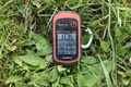
| + | Image:2022-04-24_50_11_Anna_proof.png | proof | ||
| + | |||
</gallery> | </gallery> | ||
| Line 40: | Line 49: | ||
<!-- Add any achievement ribbons you earned below, or remove this section --> | <!-- Add any achievement ribbons you earned below, or remove this section --> | ||
| − | |||
| − | |||
| − | |||
| − | |||
| − | |||
| − | |||
| − | |||
| − | |||
| − | |||
| − | |||
| − | |||
| − | |||
| − | |||
| − | |||
[[Category:Expeditions]] | [[Category:Expeditions]] | ||
| − | |||
[[Category:Expeditions with photos]] | [[Category:Expeditions with photos]] | ||
| − | |||
| − | |||
| − | |||
| − | |||
| − | |||
[[Category:Coordinates reached]] | [[Category:Coordinates reached]] | ||
| − | + | {{location|DE|TH|J}} | |
| − | |||
| − | |||
| − | |||
| − | |||
| − | |||
| − | |||
| − | |||
| − | |||
| − | |||
| − | |||
| − | |||
| − | |||
| − | |||
| − | |||
| − | |||
| − | |||
| − | |||
Latest revision as of 20:42, 26 April 2022
| Sun 24 Apr 2022 in 50,11: 50.8801597, 11.6094685 geohashing.info google osm bing/os kml crox |
Location
In a park in Jena, on top of the Autobahn.
Participants
Plans
A hash that's too close to miss, the plan was to go at any convenient time
Expedition
I went by bike, most of the way taking the route of my usual commute. The point itself was close to a path in a park, on top of Autobahn 4. The autobahn was overbuilt as a noise cancelling measure, as blocks of flats are right next to it (german Wikipedia).
From the point there was a view to the ruins of the Lobdeburg castle.
Not difficult to get to, not remarkable, just a nice morning bike ride.
Notable flora and fauna
- a kingfisher directly on the bike path, taking off when I came close
- a buzzard taking off from a horse pasture as I went past
Photos
proof
