Difference between revisions of "2022-07-18 31 34"
(→Expedition) |
m (subst-ing) |
||
| (3 intermediate revisions by 3 users not shown) | |||
| Line 8: | Line 8: | ||
And DON'T FORGET to add your expedition and the best photo you took to the gallery on the Main Page! We'd love to read your report, but that means we first have to discover it! :) | And DON'T FORGET to add your expedition and the best photo you took to the gallery on the Main Page! We'd love to read your report, but that means we first have to discover it! :) | ||
-->{{meetup graticule | -->{{meetup graticule | ||
| − | | lat= | + | | lat=31 |
| − | | lon= | + | | lon=34 |
| − | | date= | + | | date=2022-07-18 |
}}<!-- edit as necessary --> | }}<!-- edit as necessary --> | ||
__NOTOC__ | __NOTOC__ | ||
| Line 17: | Line 17: | ||
== Participants == | == Participants == | ||
| − | RonK | + | [[User:RonK|RonK]] |
== Plans == | == Plans == | ||
| Line 23: | Line 23: | ||
== Expedition == | == Expedition == | ||
| − | Drove to Ramot Meir, stopped at the grocery store parking lot to figure out how to enter the location into my mapping app; From the parking lot drove to a convenient place to park off of the road on the other side | + | Drove to Ramot Meir, stopped at the grocery store parking lot to figure out how to enter the hashpoint's location into my mapping app; From the parking lot drove to a convenient place to park off of the road on the other side from the hashpoint; Arrived by foot after a 30 second walk at the hashpoint at 08:16 and took a few photos; Didn't leave any marker, and anyway I saw from my car before leaving to go on to work that the location was tilled/plowed again a few minutes after I left it. |
== Gallery == | == Gallery == | ||
| Line 44: | Line 44: | ||
| name = RonK | | name = RonK | ||
}} | }} | ||
| − | |||
| − | |||
| − | |||
| − | |||
| − | |||
| − | |||
| − | |||
| − | |||
| − | |||
| − | |||
| − | |||
| − | |||
| − | |||
[[Category:Expeditions]] | [[Category:Expeditions]] | ||
[[Category:Expeditions with photos]] | [[Category:Expeditions with photos]] | ||
| − | |||
| − | |||
| − | |||
| − | |||
| − | |||
| − | |||
[[Category:Coordinates reached]] | [[Category:Coordinates reached]] | ||
| − | + | {{location|IL|M|RM}} | |
| − | |||
| − | |||
| − | |||
| − | |||
| − | |||
| − | |||
| − | |||
| − | |||
| − | |||
| − | |||
| − | |||
| − | |||
| − | |||
| − | |||
| − | |||
| − | |||
| − | |||
Latest revision as of 20:50, 24 May 2024
| Mon 18 Jul 2022 in 31,34: 31.8752307, 34.8593802 geohashing.info google osm bing/os kml crox |
Location
On the border of (a totally tick-free!) agricultural field in Ramot Meir, Israel, just off of an easily accessible road
Participants
Plans
Find geohash location as part of my commute to work. Even though I was much better prepared than for my first, disastrous attempt, I forgot to check Google Street View to see if there was a fence on the side of the road which would prevent me from succeeding --- but I was lucky!
Expedition
Drove to Ramot Meir, stopped at the grocery store parking lot to figure out how to enter the hashpoint's location into my mapping app; From the parking lot drove to a convenient place to park off of the road on the other side from the hashpoint; Arrived by foot after a 30 second walk at the hashpoint at 08:16 and took a few photos; Didn't leave any marker, and anyway I saw from my car before leaving to go on to work that the location was tilled/plowed again a few minutes after I left it.
Gallery
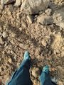
Ramot Meir hashpoint (and my shoes)
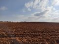
The agricultural field which contained the 2022-07-18 (31, 34) hashpoint (with runner on far side)
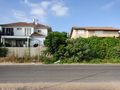
Some houses in Ramot Meir which faced the 2022-07-18 (31, 34) hashpoint (from the opposite side of the road)

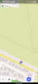
Screenshot of OsmAnd+ showing arrival at hashpoint (but too zoomed to show context)
Screenshot of OsmAnd+ showing arrival at hashpoint (with some of the houses on the other side of the road included)


Achievements
RonK earned the Land geohash achievement
|