Difference between revisions of "2022-07-21 58 5"
(→Tracklog) |
(→Expedition) |
||
| (12 intermediate revisions by 3 users not shown) | |||
| Line 27: | Line 27: | ||
== Expedition == | == Expedition == | ||
<!-- how it all turned out. your narrative goes here. --> | <!-- how it all turned out. your narrative goes here. --> | ||
| + | This was my toughest trip yet to find a geohash. The trip started quite well, it was a bit steeper and wetter than I had thought. After just over 2 km I found that I wanted to leave the path and try to get up a steep slope in the direction of the hash. There were several small cliffs if I had to climb around on the way up. I had to pull myself up by holding on to trees, bushes and heather. It took me a long time but after almost an hour in steep terrain I was finally at the top. Finding the hash went well. It was now time for a break and a rest. | ||
| + | |||
| + | I found that I was too exhausted to take the same route back to the car, so I decided that I would rather go down another route that seemed easier. I therefore decided that I would call my daughter on her mobile to ask if she could come pick me up to drive me back to my car. It was perfectly fine with her and she promised to come to pick me up so we arranged a place to meet. It was quite a steep descent but it went well. At the agreed meeting point, my daughter was already there so that she could drive me back to my car. | ||
| + | |||
| + | On the way home I stopped at a shop to buy something to drink, over a liter was drunk quite quickly. I hope it will be a long time until the next time I go on such a exhausting trip. | ||
== Tracklog == | == Tracklog == | ||
<!-- if your GPS device keeps a log, you may use Template:Tracklog, post a link here, or both --> | <!-- if your GPS device keeps a log, you may use Template:Tracklog, post a link here, or both --> | ||
| − | + | {{tracklog |Activity 9245725831xx.gpx}} | |
== Photos == | == Photos == | ||
| Line 39: | Line 44: | ||
<gallery perrow="5"> | <gallery perrow="5"> | ||
| − | Image:2022-07-21_58_5_Pica42_1658400194268.jpg| | + | Image:2022-07-21_58_5_Pica42_1658400194268.jpg|Litla Vårlifjellet [https://openstreetmap.org/?mlat=58.93513780&mlon=5.93527160&zoom=16 @58.9351,5.9353] |
| + | Image:20220721 58 5 1.jpg|View from the trail | ||
| + | Image:20220721 58 5 2.jpg|thumb|I found a lot of blueberries along the path. | ||
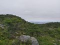
| + | Image:20220721 58 5 3.jpg|thumb|Part of the trail. | ||
| + | Image:20220721 58 5 4.jpg|thumb|View from the hash. | ||
| + | Image:20220721 58 5 5.jpg|thumb|View from the hash. | ||
| + | Image:20220721 58 5 6.jpg|thumb|View from the hash. | ||
| + | |||
</gallery> | </gallery> | ||
| Line 46: | Line 58: | ||
<!-- Add any achievement ribbons you earned below, or remove this section --> | <!-- Add any achievement ribbons you earned below, or remove this section --> | ||
| − | + | {{land geohash |name=[[User:Pica42|Pica42]] |date=2022-07-21 |latitude=58 |longitude=5 }} | |
| − | |||
| − | [[ | ||
| − | |||
| − | |||
| − | |||
| − | |||
| − | |||
| − | |||
| − | |||
| − | |||
| − | |||
| − | |||
[[Category:Expeditions]] | [[Category:Expeditions]] | ||
| − | + | [[Category:Expeditions with photos]] | |
| − | [[Category:Expeditions with photos]] | ||
| − | |||
| − | |||
| − | |||
| − | |||
| − | |||
[[Category:Coordinates reached]] | [[Category:Coordinates reached]] | ||
| − | + | {{location|NO|11}} | |
| − | |||
| − | |||
| − | |||
| − | |||
| − | |||
| − | |||
| − | |||
| − | |||
| − | |||
| − | |||
| − | |||
| − | |||
| − | |||
| − | |||
| − | |||
| − | |||
| − | |||
Latest revision as of 06:44, 23 July 2022
| Thu 21 Jul 2022 in 58,5: 58.9351553, 5.9353144 geohashing.info google osm bing/os kml crox |
Location
Litla Vårlifjellet, Sandnes, Norway
Participants
Plans
Expedition
This was my toughest trip yet to find a geohash. The trip started quite well, it was a bit steeper and wetter than I had thought. After just over 2 km I found that I wanted to leave the path and try to get up a steep slope in the direction of the hash. There were several small cliffs if I had to climb around on the way up. I had to pull myself up by holding on to trees, bushes and heather. It took me a long time but after almost an hour in steep terrain I was finally at the top. Finding the hash went well. It was now time for a break and a rest.
I found that I was too exhausted to take the same route back to the car, so I decided that I would rather go down another route that seemed easier. I therefore decided that I would call my daughter on her mobile to ask if she could come pick me up to drive me back to my car. It was perfectly fine with her and she promised to come to pick me up so we arranged a place to meet. It was quite a steep descent but it went well. At the agreed meeting point, my daughter was already there so that she could drive me back to my car.
On the way home I stopped at a shop to buy something to drink, over a liter was drunk quite quickly. I hope it will be a long time until the next time I go on such a exhausting trip.
Tracklog
Photos

Litla Vårlifjellet @58.9351,5.9353
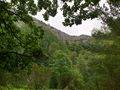
View from the trail
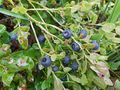
I found a lot of blueberries along the path.
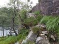
Part of the trail.
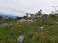
View from the hash.
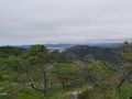
View from the hash.
View from the hash.


Achievements
Pica42 earned the Land geohash achievement
|